the Creative Commons Attribution 4.0 License.
the Creative Commons Attribution 4.0 License.
 | 18 Jun 2021
Ideas and perspectives: Ushering the Indian Ocean into the UN Decade of Ocean Science for Sustainable Development (UNDOSSD) through marine ecosystem research and operational services – an early career's take
The Indian Ocean Rim hosts many of the world's underdeveloped and emerging economies that depend on the ocean resources for the livelihoods of the populations of millions. Operational ocean information services cater to the requirements of managers and end-users to efficiently harness those resources and to ensure safety. Fishery information is not the only operational service that will be needed to empower such communities in the coming decades. Coral bleaching alerts, SCUBA (self-contained underwater breathing apparatus)-assisting advisories, conservation or ecotourism assisting services (e.g. TurtleWatch or WhaleWatch), poaching and/or by-catch reduction support and jellyfish, micro-plastic and oil spill watching to name a few, but not an exhaustive list, of the services that are needed operationally. This paper outlines the existing tools and explores the ongoing research that has potential to convert the findings into operational services in near- to midterm.
- Article
(305 KB) - Full-text XML
- BibTeX
- EndNote


About one-third of the world population reside in the Indian Ocean Rim (IOR) countries. This is projected to increase and may reach to 50 % of the global populations by the year 2050 (Doyle, 2018). The lives and livelihoods of these people are inherently intertwined with the Indian Ocean and its dynamics. These countries have very diverse cultures and philosophies. Their financial capabilities vary widely and so do their aspirations and world views. The IOR countries, thus, present a confluence of ideologies to a resource manager, with their vivid and vibrant demographics that have very different challenges and opportunities. The majority of the IOR countries either have an expansive or stationary population pyramid profile, with limited land resources. Their nutritional and employment needs will have more reliance on the Indian Ocean in the coming decades. Marine ecosystems are a promising source for the nourishment of populations and, at the same time, are under more serious threats than ever before. As more people are uplifted from poverty, consumerism is poised to extend to larger parts of the population, which will create concerns for the health of the adjoining ocean ecosystems.
The International Indian Ocean Expedition (IIOE), conducted during 1962–1965, was the first major attempt to study the Indian Ocean, its processes and diversity. It resulted into many multidisciplinary collaborations and gave birth to institutions such as National Institute of Oceanography (NIO) in India. The second IIOE (IIOE-2) was observed during 2015–2020, commemorating 5 decades of the first IIOE, and witnessed even greater participation globally. It was underlined at the onset of IIOE-2 that the Indian Ocean is a relatively poorly studied ocean of the world (Hood et al., 2016). It is, thus, important to ensure that the resources from this unique (landlocked from the north) ocean are harnessed in harmony with sustainability and with the equal opportunities. For successful planning and execution, it is imperative for the resource managers to have community participation (Martini et al., 2017). Hence, it is especially important for the IOR countries to chart the right path on the eve of the United Nations Decade of Ocean Science for Sustainable Development (UNDOSSD, 2021–2030).
The advancement of geosciences in last century has provided us with many tools to cope with the changing environment and associated challenges. The role of providing such insights in the 21st century is shifting to operational oceanography (OSOS, 2019). Operational oceanography is defined as systematic and sustained ocean observations which are converted into outputs as per the stakeholder or user requirements, using the scientific research done in the development of those outputs. Operational ocean services are the mechanism through which these outputs are disseminated effectively (often in real time or near-real time) and feedbacks are collected based on users' experience and needs (Fig. 1). A robust combination of observations and modelling, artificial intelligence, effective tools of interpretation and user-friendly dissemination of information can change millions of lives that are dependent on the oceans. This paper hypothesizes that the best possible approach to win the community attention (and to invoke the responsible ownership of the resources) is to engage the communities with the operational-ecosystem-related services. Furthermore, this paper explores the regional needs and solutions based on presently available data and technologies.
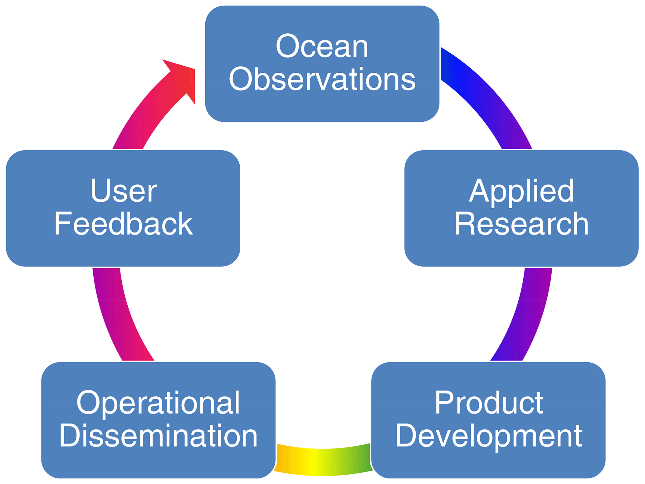
Figure 1Evolution and life cycle of an operational ocean service. After identification of user requirement and consultation with them, ocean observations are planned or retrieved (if already existing). The observations are then used for the research focused on the development of products customized for stakeholder requirement. The products are then disseminated as routine operations, and feedbacks from the users are collected for further improvement of the products. Due to the continuous advancements of the technology and changes in the user requirements, this cycle repeats to find the best achievable solutions for the contemporary needs at the user level.
The marine-ecosystem-related operational ocean information and forecast services (or products as a service) can be grouped into three major categories based on their prime objectives. The first type of services is related to resource management, conservation and support to livelihood. The second type comprises services that deal with threats to the ecosystem. The third group is the solutions for community engagement and dissemination.
2.1 Services to cater resource management, conservation and livelihood
Under the decadal initiative, the UN Sustainable Development Goal (SDG) 14 (life below water) will receive significant attention, which heavily relies on remote sensing data, in general, and, in particular, on OceanColor (OC) observations. In the late 1990s, the OC science achieved operational status (after a decade-long hiatus in a post-CZCS (Coastal Zone Color Scanner Experiment) era) due to adequate satellite coverage. Since then, researchers have made extensive use of these data despite often encountering spatial (clouds and sun glint), temporal (daily once and daytime-only coverage) or spectral (fixed and limited bands) limitations. The applications range from fisheries and aquaculture and harmful algal bloom monitoring to estimating productivity and carbon budgeting (Wilson, 2011). However, there are limitations with regards to the predictability of the base of the food pyramid itself. There are global products for primary production, such as the vertically generalized production model, that are developed with relatively low observations of the photosynthesis–irradiance parameters from the Indian Ocean (Behrenfeld and Falkowski, 1997). It is, thus, very important for the IOR countries to have regional Primary Productivity (PP) models for operational applications. This could be taken up as a priority during the UNDOSSD.
This decade is chiefly important due to the planned launch of an operational hyperspectral mission named PACE (Plankton, Aerosol, Cloud, ocean Ecosystem) by NASA in the early 2020s. A hyperspectral sensor scans oceans with a high-resolution, of as much as 1 nm, wavelength for the entire visible spectrum that enables researchers to begin a new era in the OC sciences due to its potential for developing a plethora of applications. This includes, but is not limited to, better resolving phytoplankton functional types, fishery resource management and ecosystem health monitoring. The latter is more important, especially for the second type of services and is discussed in detail in a subsequent section.
At the same time, the temporal limitations seem to be mitigated through various approaches such as using the day–night band data or OC data from the geostationary orbit such as Geostationary Ocean Color Imager (Miller et al., 2013; Ruddick et al., 2014). When OC science follows the footsteps of other satellite types, we may also have a swarm of nano-satellites or CubeSats, further improving temporal and, to some extent, spatial coverage as well. This, however, needs to be rightly balanced with the concerns of overcrowding the orbits and associated complexities (Bruinsma et al., 2021). Studies are required to shed light on the fate of ocean observations platforms (chiefly, drifting platforms) and setting up best practices to minimize their contribution to marine debris. The placement of HICO (Hyperspectral Imager for Coastal Ocean) on the International Space Station (ISS) reminds us that OC science may not be limited to satellite remote sensing in coming decades (Huemmrich et al., 2017). Validations, sampling protocols, intercomparison exercises and training for all of these will be needed. Modellers are putting efforts into assimilating data products into numerical models or making use of surface information for better resolving of subsurface characteristics; others strive for carbon or heat budgeting. With more than 2 decades of uninterrupted observations (applying the rule of thumb of a minimum of a 30-year time series), we are a few years away from making use of OC data for climate applications.
There are some proven (e.g. telemetry) and emerging (e.g. environmental DNA or eDNA) tools that can help researchers with the services related to higher trophic levels (Costa et al., 2010; Stat et al., 2017). These tools are very useful in providing vital information habitat utilization, migration, environmental preferences and presence–absence analysis. The research can then support the operational services that cater to sustainable resource management, prevent by-catch or help reduce accidental mortality. The TurtleWatch advisory by NOAA (National Oceanic and Atmospheric Administration, USA) is the best-suited example for the majority of the Indian Ocean countries (Howell et al., 2015). Other species for which such products are very much needed in the operational mode are cetaceans, sharks and marine mammals.
The operational services that can predict the movement and presence of these animals are required for conservation authorities, who can then effectively design protected areas, do better marine spatial planning or monitor potential hot spots for poaching or IUU (illegal, unreported and unregulated) fishing. Additionally, these can also support the ecotourism (e.g. WhaleWatch) as an alternate livelihood for the professional fishers, who face performing capture fishery as a less lucrative occupation. Ecotourism needs support from operational services in the form of monitoring of mangroves and coral reefs as well. Innovative ideas that put together existing observations and forecasts (e.g. water clarity from OC satellite data, currents and wave height forecasts from numerical model simulations and coral health, i.e. no bleaching and/or stress alert with the help of satellite-based SST – sea surface temperature) and generate novel products (e.g. SCUBA-buddy advisories) will support dive operators in many of the IOR countries, especially the SIDSs (small island developing states). Mariculture (open ocean cage culture) is emerging as another area of livelihood as an alternate to capture fishery and is poised to be more feasible in wider areas with newer designs of submerged cages (Korsøen et al., 2012).
Acoustics is another tool that can support the development of operational services for various stakeholders. Acoustic telemetry is useful for the species for which satellite telemetry is not suitable due to various reasons (Crossin et al., 2017), whereas the field of bioacoustics has been furthered into many sub-branches. The estimation of zooplankton biomass with the help of acoustic backscatter is not only limited to moored buoys, and these techniques have transcended to AUVs (autonomous underwater vehicles), aptly called the Zooglider (Ohman et al., 2019). Such surveys are vital for zooplankton and ichthyoplankton distribution monitoring and for ecosystem models that would connect the regional PP products to the higher trophic levels. Bioacoustics is also used for monitoring the marine animals' movements by listening to the underwater sounds, often through passive acoustic monitoring (PAM), which would be one of the less intrusive ways of studying them (Browning et al., 2017).
2.2 Services to mitigate threats to the ecosystem
Many of the human activities can be a nuisance to the marine environment in different ways, and anthropogenic sound in the ocean is one such example (Williams et al., 2015). Future operational services will need to account for and develop ways to monitor the oceanic soundscape.
Another common anthropogenic impact on the marine ecosystems is the transport and introduction of alien (non-native) species through ballast water. These species, when lacking natural predators, often turn out to be invasive and throw off the local ecological equilibrium (Bailey, 2015). Oil spills are yet another source of pollution from ships. These can be addressed to certain extent by monitoring vessel AIS (automatic identification system) data and applying artificial intelligence–machine learning (AI-ML) tools to identify the ship behavioural patterns prior to such discharges and then use it as predictive model (Soares et al., 2019).
Plastic adversely impacts the marine environment in multiple ways. The known pathways include ghost fishing (entanglement), ingestion, bioaccumulation and allied effects, as well as the transport of alien species and pollutants. Among the top 20 countries globally with inadequately managed plastic as a source of pollution in the ocean, half are the IOR countries. All of the Bay of Bengal peripheral countries face the issue of land–plastic management (Jambeck et al., 2015). Thus, the Bay of Bengal needs to be a prime focus to monitor the oceanic and beach debris in the mission mode, with the triad of in situ surveys, dispersion models and the latest remote sensing techniques (Martínez-Vicente et al., 2019). Whether it is about addressing the entry of the plastic from land to the ocean or the sustainable exploitation of shared fish stocks, progressive and tangible engagement among stakeholders through forums such as SAARC (South Asian Association for Regional Cooperation), BIMSTEC (Bay of Bengal Initiative for Multi-Sectoral Technical and Economic Cooperation), WIOMSA (Western Indian Ocean Marine Science Association) or RIMES (Regional Integrated Multi-Hazard Early Warning System for Africa and Asia), is a necessity.
On the other hand, a mass sink of jellyfish swarming has been reported in the Arabian Sea (Billet et al., 2006). Jellyfish swarms are known to be disruptive to fisheries and to cooling the water intake facilities of coastal industries with causes little known, and thus, there is the need for the development of predictive capabilities. The Arabian Sea also witnesses large-scale blooms of Noctiluca scintillans, and research in recent years may provide the foundation for the bloom forecasting (Xiang et al., 2019). Crashing of jellyfish swarms or algal blooms have implications to the deep sea ecology, particularly in regions such as the Arabian Sea, which has a prominent oxygen minimum zone (OMZ; Rixen et al., 2020). Stratified waters, such as those of the northern Indian Ocean basins, have implications for large pelagic fish, which may face additional fishing pressure with the expansion of the OMZs due to the shrinkage of the habitat (Nimit et al., 2020).
2.3 Effective dissemination and user engagement
While it is important to have robust observations and modelling capabilities in order to generate operational services and products, it is equally important to have effective dissemination. Presently, the IOR countries rely on information dissemination through conventional modes that are almost entirely land based. Dissemination of operational services on board a vessel has its own benefits during fair weather and in terms of fuel saving. However, due to the limitation of cellular signal support at sea, it is imperative that a fully fledged dissemination system should be supported through satellite communication (Singh et al., 2016). This results in episodes such as Cyclone Ockhi, where a lack of timely alerts costs many lives (Roshan, 2018). Such dissemination systems are to be provided, along with feedback mechanisms, to validate the services in real or near-real time. The feedbacks also open new avenues of data collection. Crowd-sourcing of data gathering could play an essential role in making seafarers the eyes and ears of scientists (Kelly et al., 2020).
All of the seven themes of the UNDOSSD have major implications for the needs of IOR countries and have stakeholders at its heart. Hence, operational services can be one of the most important approaches for the community engagement in the fulfilment of theme's goals. The existing frameworks of IIOE-2 and others (e.g. RIMES) may be utilized to ensure that the IOR countries can share their know-how (e.g. digital gene and/or meta-barcoding bank) and have access to the operational services, which will fulfil the “transparent ocean” and “inspiring and engaging ocean” goals. Reliable maps of oil spill and marine debris are essential for meeting the goal of a “clean ocean”. In addition to the adverse physical sea state, algal bloom and jellyfish swarming predictions are required for achieving “safe ocean” objective. Coral bleaching and SCUBA-buddy advisories can form an important pillar to a “healthy and resilient ocean” by supporting ecotourism-based alternate livelihoods. Telemetry, acoustics and genomics, aided by satellite data and model simulations, will enable us to manage responsible fisheries by virtue of a “predictive ocean”. This can, in turn, ensure “sustainable and productive oceans” for the coming generations.
No data sets were used in this article.
The author has declared that there are no competing interests.
This article is part of the special issue “Understanding the Indian Ocean system: past, present and future (BG/ACP/OS/SE inter-journal SI)”. It is not associated with a conference.
The author appreciates motivation from the director of INCOIS to take up this study. This publication was co-sponsored by the Scientific Committee on Oceanic Research (SCOR) as part of the activities of the International Indian Ocean Expedition 2. The author is grateful for the encouragement from the co-founders of the IIOE-2 ECSN (Early Career Scientists' Network). This is INCOIS contribution no. 418.
This paper was edited by Raleigh Hood and reviewed by Gad Levy and one anonymous referee.
Bailey, S. A.: An overview of thirty years of research on ballast water as a vector for aquatic invasive species to freshwater and marine environments, Aquat. Ecosyst. Health, 18, 261–268, https://doi.org/10.1080/14634988.2015.1027129, 2015.
Behrenfeld, M. J. and Falkowski, P. G.: Photosynthetic rates derived from satellite-based chlorophyll concentration, Limnol. Oceanogr., 42, 1–20, https://doi.org/10.4319/lo.1997.42.1.0001, 1997.
Billett, D. S. M., Bett, B. J., Jacobs, C. L., Rouse, I. P., and Wigham, B. D.: Mass deposition of jellyfish in the deep Arabian Sea, Limnol. Oceanogr., 51, 2077–2083, https://doi.org/10.4319/lo.2006.51.5.2077, 2006.
Browning, E., Gibb, R., Glover-Kapfer, P., and Jones, K. E.: Passive acoustic monitoring in ecology and conservation. Woking, UK, WWF-UK, WWF, Conserv. Technol. Ser., 1, 76 pp., https://doi.org/10.25607/OBP-876, 2017.
Bruinsma, S., Fedrizzi, M., Yue, J., Siemes, C., and Lemmens, S.: Charting satellite courses in a crowded thermosphere, Eos, 102, https://doi.org/10.1029/2021EO153475, 2021.
Costa, D. P., Block, B. A., Bograd, S., Fedak, M. A., and Gunn, J. S.: TOPP as a marine life observatory: using electronic tags to monitor the movements, behaviour and habitats of marine vertebrates, Proc. Ocean Obs., 9, 21–25, 2010.
Crossin, G. T., Heupel, M. R., Holbrook, C. M., Hussey, N. E., Lowerre-Barbieri, S. K., Nguyen, V. M., Raby, G. D., and Cooke, S. J.: Acoustic telemetry and fisheries management, Ecol. Appl., 27, 1031–1049, https://doi.org/10.1002/eap.1533, 2017.
Doyle, T.: Blue Economy and the Indian Ocean Rim, J. Indian Ocean Reg., 14, 1–6, https://doi.org/10.1080/19480881.2018.1421450, 2018.
Hood, R. R., Urban, E. R., McPhaden, M. J., Su, D., and Raes, E.: The 2nd International Indian Ocean Expedition (IIOE-2): Motivating New Exploration in a Poorly Understood Basin, Limnol. Oceanogr. Bull., 25, 117–124, https://doi.org/10.1002/lob.10149, 2016.
Howell, E. A., Hoover, A., Benson, S. R., Bailey, H., Polovina, J. J., Seminoff, J. A., and Dutton, P. H.: Enhancing the TurtleWatch product for leatherback sea turtles, a dynamic habitat model for ecosystem-based management, Fish. Oceanogr., 24, 57–68, https://doi.org/10.1111/fog.12092, 2015.
Huemmrich, K. F., Campbell, P. K. E., Gao, B. C., Flanagan, L. B., and Goulden, M.: ISS as a platform for optical remote sensing of ecosystem carbon fluxes: a case study using HICO, IEEE J. Sel. Top. Appl., 10, 4360–4375, https://doi.org/10.1109/JSTARS.2017.2725825, 2017.
Jambeck, J. R., Geyer, R., Wilcox, C., Siegler, T. R., Perryman, M., Andrady, A., Narayan, R., and Law, K. L.: Plastic waste inputs from land into the ocean, Science, 347, 768–771, https://doi.org/10.1126/science.1260352, 2015.
Kelly, R., Fleming, A., Pecl, G. T., von Gönner, J., and Bonn, A.: Citizen science and marine conservation: a global review, Philos. Trans. Roy. Soc. B, 375, 20190461, https://doi.org/10.1098/rstb.2019.0461, 2020.
Korsøen, Ø. J., Fosseidengen, J. E., Kristiansen, T. S., Oppedal, F., Bui, S., and Dempster, T.: Atlantic salmon (Salmo salar L.) in a submerged sea-cage adapt rapidly to re-fill their swim bladders in an underwater air filled dome, Aquacult. Eng., 51, 1–6, https://doi.org/10.1016/j.aquaeng.2012.04.001, 2012.
Martínez-Vicente, V., Clark, J. R., Corradi, P., Aliani, S., Arias, M., Bochow, M., and Vethaak, A. D.: Measuring marine plastic debris from space: initial assessment of observation requirements, Remote Sens., 11, no. 20, 2443, https://doi.org/10.3390/rs11202443, 2019.
Martini, U., Buffa, F., and Notaro, S.: Community participation, natural resource management and the creation of innovative tourism products: Evidence from Italian networks of reserves in the Alps, Sustainability, 9, 2314, https://doi.org/10.3390/su9122314, 2017.
Miller, S. D., Straka, W., Mills, S. P., Elvidge, C. D., Lee, T. F., Solbrig, J., Walther, A., Heidinger, A. K., and Weiss, S. C.:. Illuminating the capabilities of the suomi national polar-orbiting partnership (NPP) visible infrared imaging radiometer suite (VIIRS) day/night band, Remote Sens., 5, 6717–6766, https://doi.org/10.3390/rs5126717, 2013.
Nimit, K., Masuluri, N. K., Berger, A. M., Bright, R. P., Prakash, S., TVS, U., Rohit, P., Ghosh, S., and Varghese, S. P.: Oceanographic preferences of yellowfin tuna (Thunnus albacares) in warm stratified oceans: A remote sensing approach, Int. J. Remote Sens., 41, 5785–5805, https://doi.org/10.1080/01431161.2019.1707903, 2020.
Ohman, M. D., Davis, R. E., Sherman, J. T., Grindley, K. R., Whitmore, B. M., Nickels, C. F., and Ellen, J. S.: Zooglider: an autonomous vehicle for optical and acoustic sensing of zooplankton, Limnol. Oceanogr.-Method., 17, 69–86, https://doi.org/10.1002/lom3.10301, 2019.
OSOS: 1st International Operational Satellite Oceanography Symposium, 18–20 June 2019, College Park, MD, United States, 2019.
Rixen, T., Cowie, G., Gaye, B., Goes, J., do Rosário Gomes, H., Hood, R. R., Lachkar, Z., Schmidt, H., Segschneider, J., and Singh, A.: Reviews and syntheses: Present, past, and future of the oxygen minimum zone in the northern Indian Ocean, Biogeosciences, 17, 6051–6080, https://doi.org/10.5194/bg-17-6051-2020, 2020.
Roshan, M.: Cyclone Ockhi: disaster risk management and sea safety in the Indian marine fisheries sector, Chennai, India, International Collective in Support of Fishworkers, 73 pp., ISBN 978-93-80802-73-2, 2018.
Ruddick, K., Neukermans, G., Vanhellemont, Q., and Jolivet, D.: Challenges and opportunities for geostationary ocean colour remote sensing of regional seas: A review of recent results, Remote Sens. Environ., 146, 63–76, https://doi.org/10.1016/j.rse.2013.07.039, 2014.
Singh, D., Kimbahune, S., and Singh, V. V.: Mobile signal extension in deep sea – Towards a safe and sustainable fisheries, in: 2016 ITU Kaleidoscope: ICTs for a Sustainable World (ITU WT), IEEE, 1–8, https://doi.org/10.1109/ITU-WT.2016.7805711, 2016.
Soares, A., Dividino, R., Abreu, F., Brousseau, M., Isenor, A. W., Webb, S., and Matwin, S.: CRISIS: integrating AIS and ocean data streams using semantic web standards for event detection, in: 2019 International Conference on Military Communications and Information Systems (ICMCIS), IEEE, 1–7, https://doi.org/10.1109/ICMCIS.2019.8842749, 2019.
Stat, M., Huggett, M. J., Bernasconi, R., DiBattista, J. D., Berry, T. E., Newman, S. J., Harvey, E. S., and Bunce, M.: Ecosystem biomonitoring with eDNA: metabarcoding across the tree of life in a tropical marine environment, Sci. Rep., 7, 1–11, https://doi.org/10.1038/s41598-017-12501-5, 2017.
Williams, R., Erbe, C., Ashe, E., and Clark, C. W.: Quiet (er) marine protected areas, Mar. Pollut. Bull., 100, 154–161, https://doi.org/10.1016/j.marpolbul.2015.09.012, 2015.
Wilson, C.: The rocky road from research to operations for satellite ocean-colour data in fishery management, ICES J. Mar. Sci., 68, 677–686, https://doi.org/10.1093/icesjms/fsq168, 2011.
Xiang, C., Tan, Y., Zhang, H., Liu, J., Ke, Z., and Li, G.: The key to dinoflagellate (Noctiluca scintillans) blooming and outcompeting diatoms in winter off Pakistan, northern Arabian Sea, Sci. Total Environ., 694, 133396, https://doi.org/10.1016/j.scitotenv.2019.07.202, 2019.