the Creative Commons Attribution 4.0 License.
the Creative Commons Attribution 4.0 License.
 | 10 Nov 2025
Fire activity in the northern Arctic tundra now exceeds late Holocene levels, driven by increasing dryness and shrub expansion
Angelica Feurdean
Randy Fulweber
Andrei-Cosmin Diaconu
Graeme T. Swindles
Mariusz Gałka
Tundra ecosystems are characterized by small, rare and infrequent fires due to cold, often waterlogged conditions, and limited biomass. However, ongoing climate warming and drying in northern soils and peatlands are contributing to increasingly frequent and extensive wildfires. To place recent fire regimes in the context of long-term variability and to better understand interactions between fire, moisture, and vegetation, we reconstructed wildfire history over the past 3000 years using a network of charcoal, vegetation, and hydrological records in combination with satellite-derived fire datasets from northern Arctic Alaska peatlands. The composite charcoal record shows minimal fire activity from ∼ 1000 BCE to 1000 CE, followed by a modest increase between 1000 and 1200 CE, and then a renewed decline. This long-term pattern shifted abruptly after 1900 CE, reaching its maximum between 1950 and 2015 CE, when fire activity exceeded any levels observed in the preceding three millennia. Individual charcoal records show a spatially heterogeneous pattern in fire occurrence before 1950 CE, and a more homogeneous one thereafter. Our findings suggest that the deepening of water tables and peatland drying associated with permafrost thaw have facilitated woody encroachment, especially by more flammable Ericaceous shrubs. These vegetation changes have increased fuel availability and flammability, ultimately driving the recent surge in wildfire activity, highlighting the growing vulnerability of Arctic tundra ecosystems to fire. We also found that the charcoal source area of our tundra fire reconstruction encompasses broader landscapes over tens of kilometres. Our study emphasizes the significance of long-term, multidisciplinary research in documenting moisture–vegetation–fire feedbacks that influence tundra fire regimes. Ultimately, this long-term fire dynamic study provides critical context for evaluating recent changes and incorporating tundra peatland fire risk into global climate mitigation strategies.
- Article
(7036 KB) - Full-text XML
-
Supplement
(307 KB) - BibTeX
- EndNote


Short-term records of fire activity derived from satellite observations indicate that many northern tundra regions have experienced an unprecedented increase in the number, size, and intensity of individual fires, as well as the length of the fire seasons in recent decades (Descals et al., 2022; Scholten et al., 2021, 2024). The Arctic tundra biome inhabits some of Earth's coldest regions, characterized by low above-ground biomass productivity. However, Arctic regions store approximately half of the global belowground soil organic carbon in peatlands (Loisel et al., 2021). Cold and waterlogged conditions in Arctic soils and peatlands often constrain fires to small, rare, and infrequent events, limiting burning depth and carbon loss (Archibald et al., 2013; Turetsky et al., 2015; Whitman et al., 2018, 2019; Sayedi et al., 2024). Recent rising temperatures, increased lightning frequency, changes in peatland hydrology, and greater shrub biomass contributed to a deviation from the previously low fire activity (Scholten et al., 2024). Well-hydrated peatlands composed of moss and sedges can be resistant to droughts and exhibit only moderate surface fire damage compared to peatlands dominated by shrub and tree communities (Magnan et al., 2012; Kettridge et al., 2015; Whitman et al., 2018). Deep burns can smoulder over winter in hydrologically disturbed peatlands and re-ignite during spring (Scholten et al., 2021).
While satellite data offer high temporal and spatial resolution of many aspects of the fire regime, they are limited to the past few decades. Therefore, satellite records alone cannot reveal how recent aspects of fire regimes compare to longer-term variability. Charcoal analysis from sedimentary records provides critical insights into the long-term dynamics of fire, offering essential spatial-temporal context for assessing recent changes. Combined with reconstructions of vegetation communities and hydrological conditions, enables the investigation of past tundra fire regimes under various climatic conditions and vegetation compositions (Higuera et al., 2008; Vachula et al., 2020; Hoecker et al., 2020; Sim et al., 2023). Therefore, approaches with a broad temporal and spatial scope facilitate an evaluation of feedbacks between fire and drivers, forming a foundation for understanding how tundra fire regimes may respond to future climate and vegetation development scenarios.
Although some palaeoecological records of tundra fires in Arctic Alaska exist, mainly from lake archives (Hu et al., 2010; Higuera et al., 2008; Chipman et al., 2015; Chipman and Hu, 2017; Vachula et al., 2020; Hoecker et al., 2020; Frank-DePue and Chipman, 2025), combined records documenting fire history, plant species composition, and hydrological variability from peatlands remain rare (Gałka et al., 2018; Cleary et al., 2024). The lack of a multiproxy approach limits our understanding of how fires interact with vegetation and hydrological conditions. Another challenge in reconstructing past tundra fires is understanding the source areas of charcoal and the amount of charcoal incorporated into fossil records during fire events (Vachula et al., 2020). Compared to lakes, peatlands provide local-scale reconstructions of past fire regimes, with the source area of charcoal from a fire typically extending only a few kilometres (Conedera et al., 2009; Remy et al., 2018). This fine-scale resolution reflects the pronounced heterogeneity in local peat moisture, vegetation composition and structure, and the relatively small catchment area (Magnan et al., 2012; Remy et al., 2018; Barhoumi et al., 2019; Stivrins et al., 2019; Feurdean et al., 2020; Kuosmanen et al., 2023). Because wildfire patterns are highly variable at a small spatial scale, multi-site peatland reconstructions are necessary to identify broader trends in fire regime dynamics beyond the local scale.
To place modern fire regimes in the context of long-term variability, we reconstructed 3000 years of wildfire history using six new and three previously published macrocharcoal records from a tundra region north of the Brooks Range in Arctic Alaska. We combined satellite and charcoal records, primarily from the tussock and shrubby tussock tundra zones, with data on local (plant macrofossils) and regional (pollen) vegetation and hydrological changes (testate amoebae) to investigate how interactions between peatland hydrology and vegetation affect fuel availability, dryness, and flammability. We hypothesize that the recent increase in fire frequency in northern Alaska is linked to the lowering of the permafrost layer and the deepening of the water table, resulting in the expansion of shrubs on dry peatlands. We also aim to refine the understanding of charcoal source areas in tundra fire reconstructions by comparing our charcoal records with satellite-derived data on fire size and frequency.
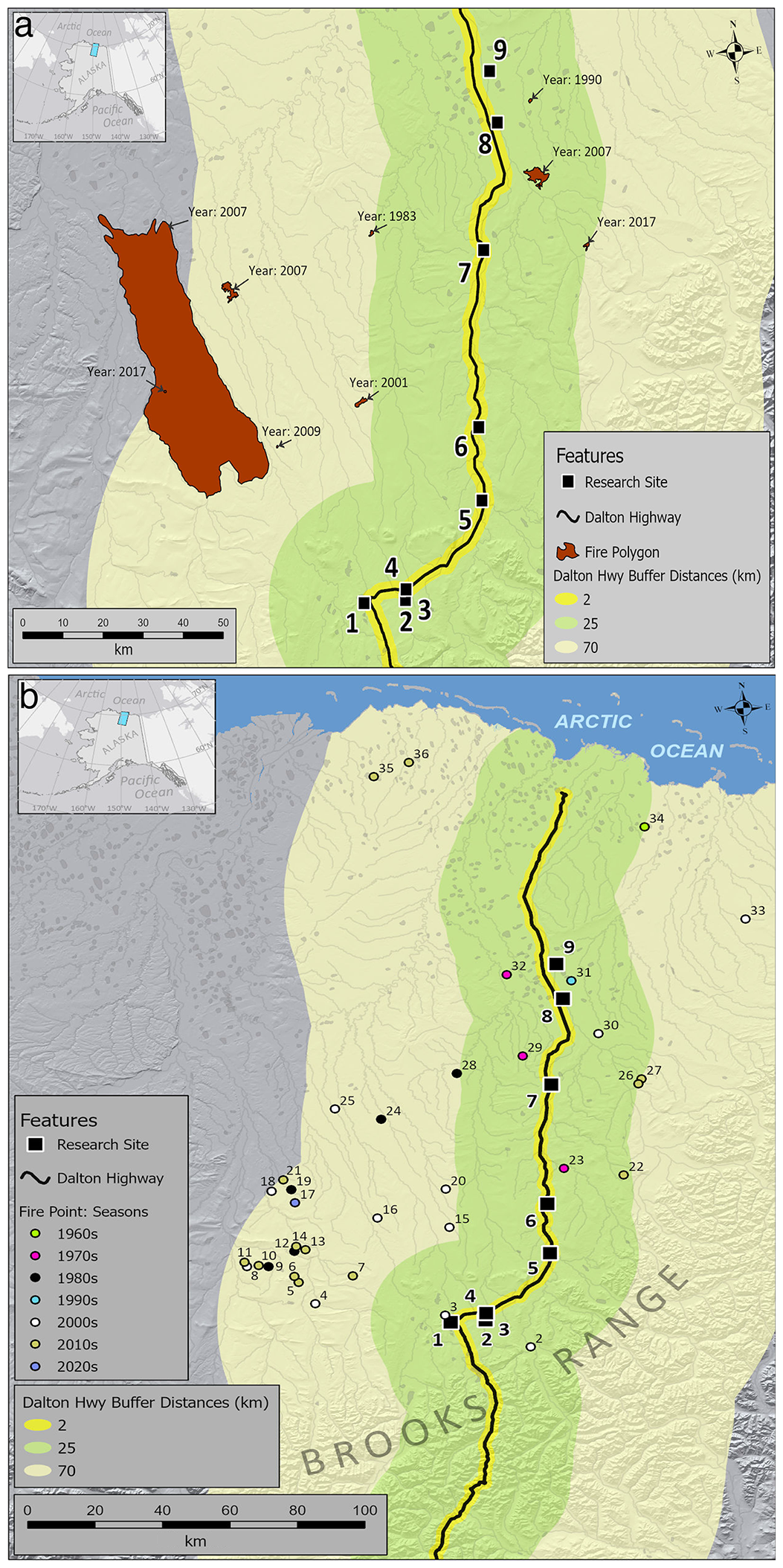
Figure 1Location of the study area in northern Alaska. Charcoal sampling sites numbered 1 to 9 are situated along the Dalton Highway, extending from the northern slope of the Brooks Range Mountains to the Arctic Ocean. Site names and coordinates are listed in Table 1. (a) depicts large fires as polygons and their respective time of occurrence. (b) represents small fires as points, with colour coding of each fire point indicating the decade in which the fire occurred, while the numbers refer to their specific locations (for fire names, coordinates, size, and distance from the Dalton Highway and sampling sites see Table S1 in the Supplement).
Table 1Information on site ID, geographic coordinates, elevation, core lengths (in cm and age), the dominant vegetation, and references at the coring points.
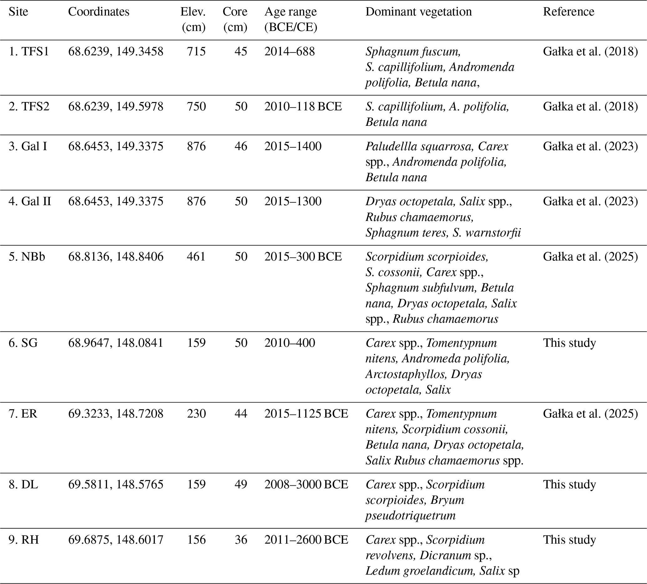
The study area is located within the continuous permafrost zone of northern Alaska, on the northern side of the Brooks Range Mountains (Fig. 1). The landscape features a mosaic of peatland types, small glacial lakes, kames, and moraines (Hamilton, 1986). The region experiences a continental Arctic climate, with a mean annual temperature of approximately 0 °C. Mean seasonal temperatures range from−22.5 °C in winter to +11.2 °C in summer. Annual precipitation averages 250 mm, falling predominantly as snow (Environmental Data Center Team, 2024). The number of snow-free days is approximately 110, although brief snowfall can occur during summer (Cox et al., 2017). The main vegetation types are dwarf-shrub and tussock sedges-moss-dwarf shrub communities, composed of sedges, brown mosses, Sphagnum, and shrub species, with composition varying by site (Walker et al., 1994, 2005; Table 1; Appendix A).
The study sites were distributed along a 150 km transect parallel to the Dalton Highway, extending from the northern foothills of the Brooks Range to the Arctic Ocean (Fig. 1). In the summer of 2015, we collected nine cores from six peatlands and one dry up hollow. Peat cores (monoliths) were retrieved using a long-bladed shovel, dug to the mineral substrate, and the sediments from the dry hollow were retrieved using a Russian-type corer. All cores were placed in PVC tubes, transported, and deposited in a cold room at the University of Łódź, Poland (Gałka et al., 2018). Details on geographic coordinates, elevation, core lengths, and dominant vegetation at the coring points are provided in Table 1.
3.1 Chronology
Chronologies were established using radiocarbon dating via Accelerator Mass Spectrometry (AMS), applied to a combination of plant macrofossils and bulk peat samples, supplemented by 210Pb dating for recent sediments (Table B1). Detailed chronology for Toolik I and II (TFSI and II) are published in Gałka et al. (2018), for GaI and GaII in Gałka et al. (2023), and for NBb and Erin (ER) are presented in Gałka et al. (2025). Age-depths models for all sites are presented in Appendix B, along with details on chronology for the three unpublished sites, SG, RH, and DL.
3.2 Macroscopic charcoal inferred fire history
We reconstructed changes in local-scale fire activity based on macroscopic charcoal analysis of 1–2 cm3 sample volumes taken at 1 cm contiguous intervals across cores from all sites. Sample preparation involved overnight bleaching using sodium hypochlorite (domestic bleach) and wet sieving through a 150 µm mesh. Charcoal identification and categorization of morphotypes (the latter conducted for 6 of the 8 records) followed the protocols of Feurdean et al. (2017) and Feurdean (2021). Charcoal morphologies were then grouped into non-woody (graminoids and forbs) and woody to determine the dominant fuel type. We also separate the charcoal fractions (5 out of 8 records) into two size classes: 150–500 µm and > 500 µm, to distinguish more local from more regional fires (Adolf et al., 2018). Additionally, we searched for large macrocharcoal fragments in samples used for plant macrofossil analysis. For this, 12 cm3 contiguous sediment samples were washed and sieved using a 200 µm mesh without applying bleaching, following Gałka et al. (2018).
Charcoal accumulation rate (CHAR ) was calculated by dividing the particle concentration (particles cm−3) by the deposition time derived from the age-depth models (yr cm−1). To account for changes in sedimentation rates, which increased markedly in the upper sections of the records, CHAR values were interpolated to a median temporal resolution for each record.
3.3 Plant macrofossils and pollen-based reconstruction of vegetation dynamics
We extracted shrub abundance from existing plant macrofossil and pollen records from TFSI, TFSII (Gałka et al., 2018), GaI, GaII (Gałka et al., 2023), NBb, and Erin (Gałka et al., 2025) to determine the local and regional changes in woody vegetation (Table 1). Total shrub pollen percentages represent the combined abundance of Betula nana, Alnus, Salix, Ericaceae, Vaccinium, Rubus chamaemorus, and Dryas octopetala. For plant macrofossils, above-ground remains (seeds, leaves, and fruits) of Andromeda polifolia, Betula nana, Ledum groenlandicum, Vaccinium, and Salix spp. were quantified as counts. In contrast, the abundance of unidentified shrub roots was expressed as a volume percentage relative to the total vascular plant and moss remains.
3.4 Testate amoebae reconstruction of hydrological changes
Changes in peatland hydrology were assessed using existing testate amoeba depth-to-water level (DTW) reconstructions from the TFSI, TFSII (Taylor et al., 2019), GaI, GaII (Gałka et al., 2023), and ER (Gałka et al., 2025). All cores were collected from similar peatland types, specifically small hummock microforms. Quantitative reconstructions of water table depth were derived using the transfer function developed by Taylor et al. (2019).
3.5 Composite records of fire, vegetation, and hydrological changes
To assess fire history across the study area, we developed a composite record of charcoal accumulation rate by combining all individual interpolated charcoal records (n=9). We generated a composite CHAR record following the protocol of Blarquez et al. (2014), which involves MinMax re-scaling, a Box–Cox transformation to homogenize variance across records, and Z-score standardization using a baseline period of last 2000 years. The transformed time series was smoothed using a LOWESS smoother with a 200 year window. Confidence intervals were estimated from the distribution of 1000 bootstrapped replicates.
To determine local and regional changes in woody vegetation, we created composite records of shrub abundance derived from individual pollen and plant macrofossil datasets (n=5). For plant macrofossils, two separate composite records were constructed, one for above-ground remains (seeds, leaves, and fruits) and one for root remains. Composite pollen and macrofossil time series were generated by applying a LOWESS smoothing with a 200 year window.
Hydrological changes were reconstructed by creating a composite DTW record (n=5). This was developed by combining existing individual records of DTW, using a Z-score transforming the DTW data (Swindles et al., 2019), and applying a LOWESS smoothing with a 200 year window.
3.6 Fire identification from satellite images
To determine recent trends in fire activity, evaluate our understanding of charcoal source areas, and the amount of charcoal produced in tundra fire, we downloaded two datasets available from the Alaska Interagency Coordination Center (AICC) website: Alaska Fire History Location Points (fire points) and Alaska Fire History Perimeter Polygons (fire polygons; Miller et al., 2023). In case of fire polygons, the area burned was based on the size of the polygon; non-vegetated surfaces were not removed. In case of fire point data, the reported incident size was estimated from field observations or calculated using GIS from perimeter polygons; therefore, the recovered size of fire from fire point data should be treated with caution. Spatial analysis was conducted using ArcGIS v.3.4.3 with the coordinate system set to the Alaska Albers Equal Area Conic (EPSG: 3338) projection. We identified those fire points (n=35) and fire polygons (n=9) that fell within 2, 25, and 70 km from the Dalton Highway, north of the Brooks Range (Fig. 1). We calculated the distance from each fire point and fire polygon from the Dalton Highway as well as the distance from the nearest five fire points to each of the fossil record. For the fire point data, an estimate of the area burned is provided in hectares (Table S1 in the Supplement). For the polygon data, the size of the fire is reported as area in hectares, determined by the ArcGIS' Calculate Geometry Attributes tool (Table S2 in the Supplement).
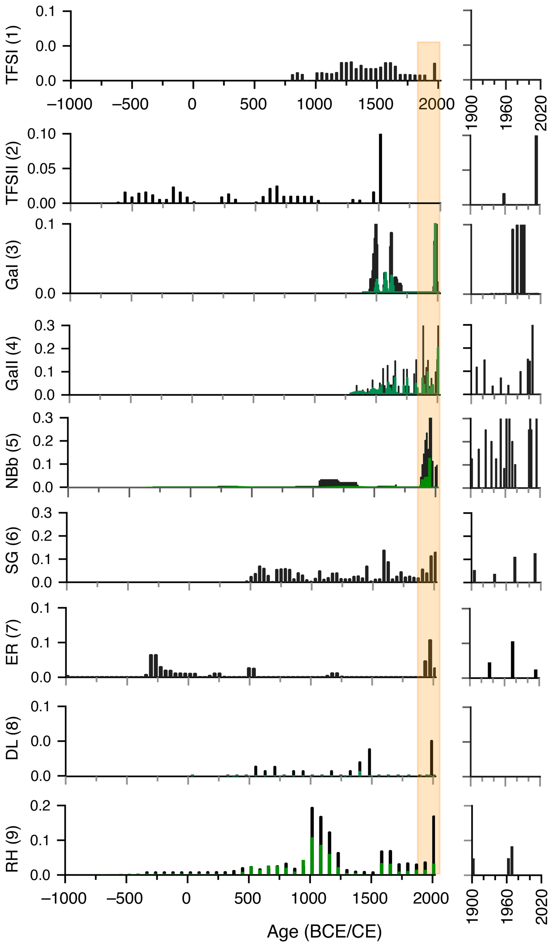
Figure 2Total interpolated charcoal accumulation rates (black bars) and separated on woody charcoal morphologies (green bars; ) at 9 sites along the Dalton Highway. The numbers in brackets indicate the site numbers as marked in Fig. 1. At sites with identified woody morphologies, the difference between the total charcoal and the woody morphology represents the morphologies formed by herbs (grass leaves, stems of forbs, and grasses) and broadleaves. On the right-hand side are trends in charcoal charcoal accumulation rates over the last century. The orange rectangle highlights the period of marked increase in total charcoal influx. BCE = before Common Era; CE Common Era.
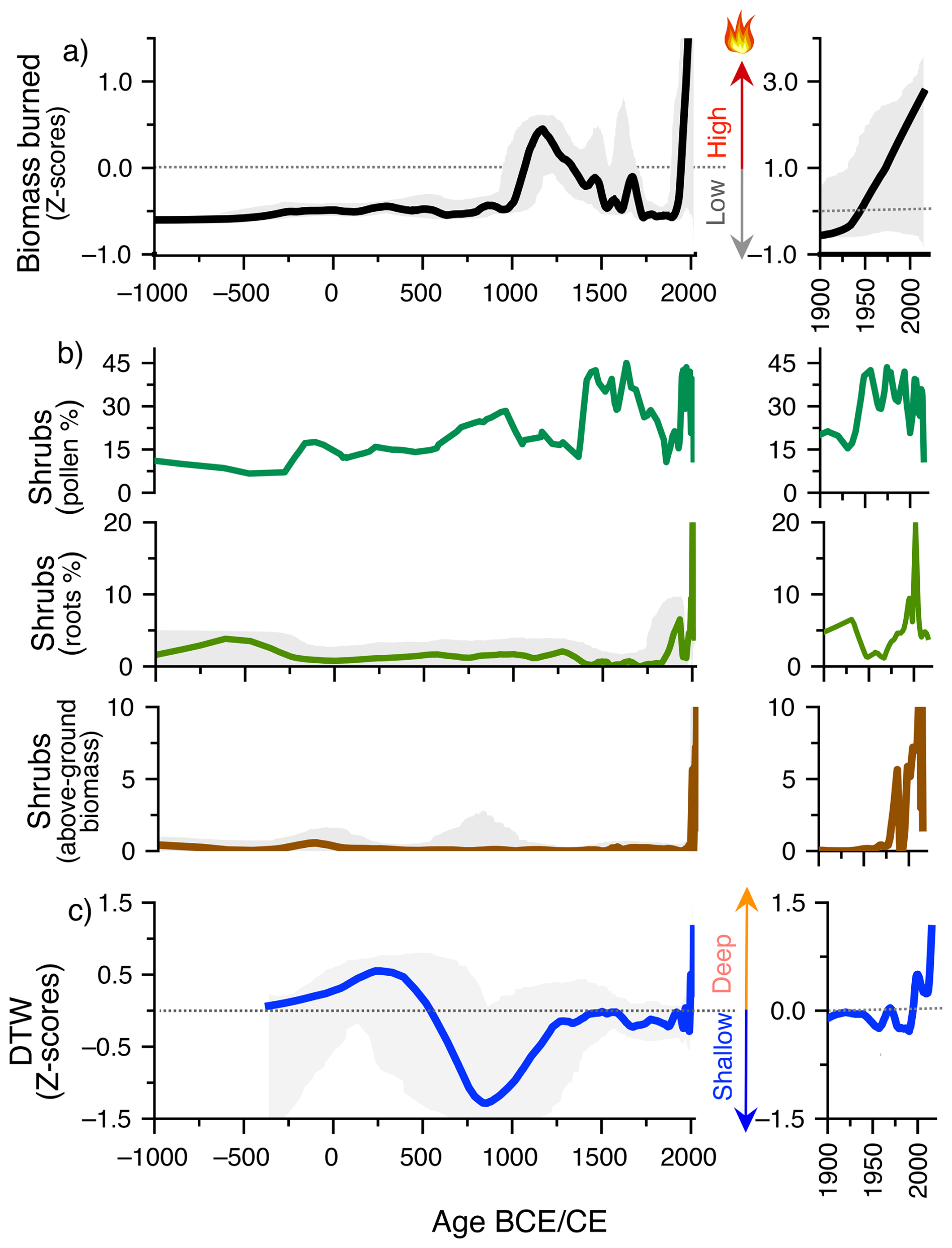
Figure 3(a) Composite record of biomass burning (n=9) based on Z-score charcoal accumulation rates, where positive/negative Z-score values represent greater-than-mean/lower-than-mean charcoal amount, over the base period, interpreted as high/lower values in biomass burning. (b) Composite record (n=5) of the abundance of shrubs determined from pollen and plant macrofossils, where pollen and root shrub biomass are represented as %, and above-ground remains (seeds, leaves, fruits) as counts (c). Composite record of peatland hydrology (n=5) from testate amoeba, where positive/negative Z-score values represent higher (shallow)/lower (deep) than the mean water level. Grey shadows represent confidence intervals. The inserts represent trends over the last two centuries.
4.1 Charcoal based biomass burning
Of the nine macrocharcoal records analysed, seven span the last one to two millennia, while only two extend as far back as 1000 BCE albeit at low temporal resolution (Fig. 2). CHAR values are consistently low across all sites, ranging from 0 to 1.07 (mean = 0.04 ± 0.11 ). The highest mean CHAR values were observed at SG (0.05 ) and NBb (0.09 ). Interpolated individual and composite CHAR records indicate consistently low biomass burning (negative Z-scores) between ∼ 1000 BCE and 1000 CE (Figs. 2 and 3). A temporary increase in composite CHAR is observed after ∼ 1000 CE, peaking around 1200 CE (positive Z-scores), followed by a decline to negative Z-scores; however, values remained higher than those recorded prior to 1000 CE. Elevated CHAR values around 1200 CE are particularly visible at TFSII, NBb, ER and RH. A continuous rise in composite CHAR begins around 1900 CE, reaching its maximum between 1950 and 2015 CE (positive Z-scores), a trend consistently reflected across all individual records.
The charcoal morphological record indicates an almost equal representation of herbaceous (e.g., grass leaves and stems of grasses and forbs) and woody charcoal morphologies, with higher woody influx towards recent times (Fig. 2). Small-size charcoal particles (150–500 µm) dominate over the larger fraction (> 500 µm) (Appendix C). No large macrocharcoal fragments (> 1 mm) were detected in plant macrofossil records.
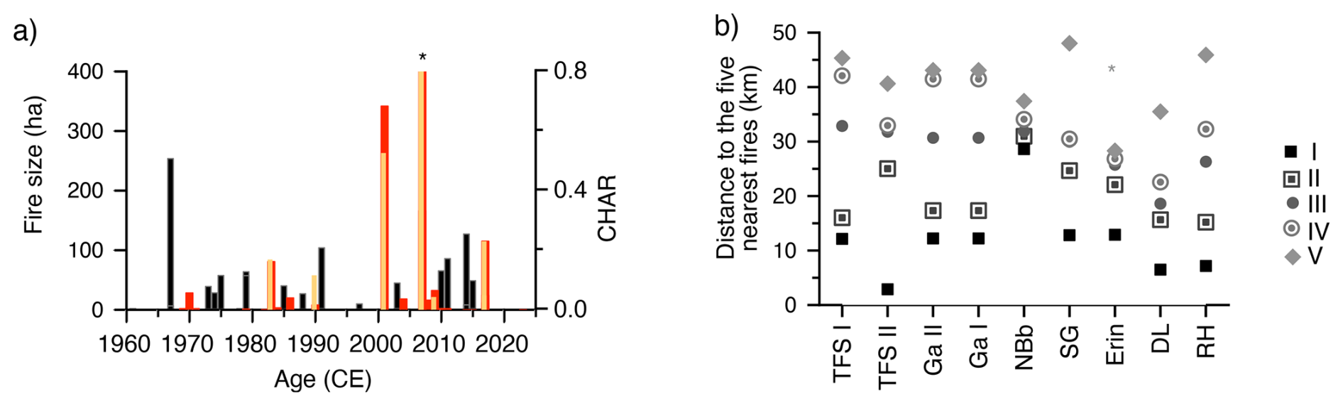
Figure 4(a) Comparison of fire frequency and size (ha) represented as fire points (red bars) and fire polygons (orange bars) from satellite imagery with interpolated charcoal influx (black bars; ): ∗ Note: The full extent of large fire occurring in 2007 (103 896 ha) is not shown to improve visibility of trends in smaller fire events. (b) Distance to nearest five fires from each of the sites: I = denote the nearest and V = the furthest from each of the sites.
4.2 Satellite and charcoal-based fire record: a comparison
Our satellite imagery record of fire points within a 70 km buffer along the Dalton Highway shows that 36 fires occurred between 1969 and 2023 (Table S1). Except for an extremely large fire of 103 896 ha occurring in 2007, most recorded fires were of small size (mean = 46 ha; median = 2 ha). Fire polygon data indicate nine fires with a mean size of 11825 ha (median = 115 ha; Figs 1a and 4a; Table S2). There were 10 recorded fires (0.5 per year) between 1969 and 1990, followed by a fire-free period from 1990 to 2001 (Fig. 4a and b). Fire activity increased markedly between 2001 and 2017, with 23 recorded fires (1.5 per year), before declining again, with only one fire observed in 2023.
On a temporal scale, we found that the nearest fires to the sampling points (range 3–29 km; mean 12 km) occurred in years 1971, 1979, 1990, and 2007, and the nearest sampling points to these fires were TFSII (3 km), DL (6.5 km), and RH (7 km) (Figs 1a, b and 4b; Table S3 in the Supplement). The second closest fires from the charcoal sampling (range 15–31 km; mean 20 km) occurred in years 1969, 1970, 1971, 1979, 1983, 1990, 2004, 2007, 2017. Given the inherent chronological uncertainties in sedimentary records and the very low amount of charcoal in our data, the slight increases in interpolated CHAR centred around the years 1965–1975, 1985–1990, and 2010–2015, may correspond to documented fire events occurring during seasons 1969–1983, 1990 and 2004–2017 (Figs 1a, b and 4a; Table S3). However, the CHAR record suggests greater burning activity around the 1970s. In contrast, satellite data indicate maximum fire size and frequency between 2001 and 2017 CE (Fig. 4a).
4.3 Vegetation changes
The pollen-based composite vegetation record, representing shrub abundance at local to regional scales, indicates consistently low shrub abundance (∼ 12 %) between 1000 and 500 BCE (Fig. 3b). A slight increase is observed from 250 CE (∼ 15 %) and again between 500 and 1000 CE (∼ 20 %). A marked rise in shrub abundance (∼ 40 %) occurs from approximately 1400 CE to the present, interrupted by brief declines between 1800 and 1945 CE and in the most recent samples.
The composite plant macrofossil record, reflecting local-scale shrub abundance, shows very low percentages of above-ground remains (∼ 2 %) from 1000 BCE to 1950 CE (Fig. 3b). A sharp increase (∼ 15 %) occurs after 1950 CE, continuing to the present. In contrast, the below-ground macrofossil record (roots) shows an increase beginning around 1900 CE, and after 1950 CE. A slightly elevated root abundance is also evident between ∼ 750 and 250 BCE (Fig. 3b).
4.4 Hydrological changes
The composite water table record indicates predominantly low (deep) water levels (positive Z-scores) between ∼ 250 and 500 CE and again between ∼ 1250 and 1600 CE, with persistently low levels over the past ∼ 50 years (Fig. 3c). The pronounced deepening around 250 CE is primarily driven by lower water levels at two of the three available sites: TFSII (Taylor et al., 2019) and NBb (Gałka et al., 2025). In contrast, shallow water levels (negative Z-scores) are primarily recorded between ∼ 500 and 1250 CE.
5.1 Charcoal source areas in tundra fire reconstructions link to fire proximity and fuel type
Our analysis of charcoal size classes reveals that most particles fall within the 150–500 µm range, with only a small proportion exceeding 500 µm, and no macrocharcoal fragments (> 1 mm) are identified (Fig. 2; Appendix C). The dominance of smaller particles, together with evidence that the nearest recent fires occurred at a mean distance of ∼ 12 km away, suggests that the charcoal source areas of our tundra fires encompass broader landscapes (Figs. 1 and 4c). Whilst typical source areas for macrocharcoal are estimated to be a few kilometers, particularly in peatlands, regional source areas extending to 20 km and beyond, i.e., up to 100 km, have also been reported (Higuera et al., 2005, 2007; Adolf et al., 2018; Vachula et al., 2020). This is particularly true for smaller, lighter, and more aerodynamic particles, often of herbaceous origin, or under the specific wind and fire behaviour conditions (Vachula et al., 2020; Vachula and Rehn, 2023).
The timing of elevated charcoal accumulation rates in isolated but mostly in several consecutive samples around 1965–1975, 1985–1990, 2005, and 2010–2015, corresponds reasonably well with periods of frequent fires documented by satellite records (Figs 1a, b and 4a). The high CHAR values observed in 2005 and between 2010 and 2015 (Fig. 4a), particularly at sites 1 to 7 (Fig. 2), may have been derived from the large fires, such as the Anaktuvuk River fire (2007), and others that occurred in 2007 (Fig. 1a and b), suggesting a link with fire size. The occurrence of a few small fires is also noted in 2000s (white dots) and 2010s (yellow dots; Fig. 1b) near most sites. In contrast, the elevated CHAR values in the 1970s (Fig. 4a), particularly evident at sites 5 to 9 (Fig. 2), correspond to a few small fires near these sites (Fig. 1b, pink dots), implying a link to the proximity of fire. However, because the closest documented fires occurred at considerable distances (3–29 km) from our sampling sites, and fire source areas often overlapped, it remains difficult to conclude whether the elevated CHAR values primarily reflect fire size and proximity, or a combination of both.
An intriguing outcome of the charcoal–satellite comparison is that the most recent large fires (2001–2015 CE) are associated with lower-amplitude charcoal signals. This feature contrasts with the occurrence of less frequent, smaller fires between 1969 and 1985 CE and higher charcoal levels (Fig. 4). This discrepancy may relate to differences in the type of biomass burned and fire intensity. Graminoids produce substantially less charred material per unit biomass than forbs and shrubs, particularly ericaceous species. High fire temperatures can lead to near-complete biomass consumption, resulting in the production of ash (Pereboom et al., 2020; Feurdean, 2021). Peatland dryness has intensified in recent times, potentially favouring higher fire temperatures and complete biomass combustion and may therefore explain the low charcoal values observed during recent large fires. These findings highlight the complexity of interpreting charcoal records, as charcoal abundance reflects not only fire size and proximity, but also fuel amount and type, as well as combustion conditions (see Sect. 5.3).
5.2 Pattern in Arctic Alaska peatland burning
Our satellite-based fire database from the northern slopes of the Brooks Range along the Dalton Highway agrees with previous findings that many tundra ecoregions of Alaska have experienced a marked increase in fire frequency and size over the past 5 decades (Higuera et al., 2008; Vachula et al., 2020; Miller et al., 2023; Scholten et al., 2024). Specifically, our data show that lightning-ignited fires occurred at an average rate of 0.5 per year between 1969 and 1990, followed by a fire-free period from 1990 to 2001 CE. Fire activity surged again between 2001 and 2017 CE, with an average of one fire every 1.5 years and larger burned areas, before declining in the most recent years (Fig. 4a and b). Historical evidence from 1948 aerial imagery further documents tundra fires that burned sometime between 1880 and 1920 on the northern Brooks Range, i.e, near the Ketik and Meade Rivers, Shivugak, and Starfish Bluff, with additional anecdotal records mentioning fires in 1952 and 1959 on the Arctic Slope (Miller et al., 2023).
Our individual and composite charcoal records spanning the past three millennia indicate very low fire activity in Arctic tundra from ∼ 1000 BCE to 1000 CE (Figs. 2 and 3). A slight increase occurred after 1000 CE, peaking around 1200 CE, but overall burning remained low until ∼ 1950 CE, when both individual and composite records show an abrupt and unprecedented rise in fire activity. This recent increase contrasts sharply with the rare and long fire-free intervals of the Holocene and supports findings from other tundra ecoregions in Arctic Alaska in documenting unusually frequent fires in these cold, with low-above ground biomass ecosystems (Higuera et al., 2008, 2011; Chipman et al., 2015; Hu et al., 2015; Vachula et al., 2020; Hoecker et al., 2020; Frank-DePue and Chipman, 2025). Holocene charcoal records from the northern slope of Alaska further indicate that fire return intervals were even longer prior to 3000 years ago. However, shorter fire cycles, like those observed in modern tundra fires, were also detected (Frank-DePue and Chipman, 2025). Another finding of our study is that individual charcoal records show a heterogeneous pattern in fire occurrence before 1950 CE, and a more homogeneous one thereafter, consistent with the emergence of more regularly occurring fires in recent decades. Lower temporal resolution and larger age control errors in the older part of the sediments could have also contributed to this apparent heterogeneity. However, the more elevated values in biomass burning around 1200 and 1600 CE, visible at multiple sites, suggests that homogenous fire occurrence across sites in the past could also be reconstructed.
5.3 Drivers of peatland burning
Recent increases in temperature and lightning frequency are often cited as key drivers of enhanced fire activity across Arctic tundra regions (Hu et al., 2010, 2015; Hoecker et al., 2020; Sim et. al., 2023; Scholten et al., 2024). Our independent reconstruction of peatland hydrology reveals that the lowest water table levels (positive Z-score), indicating the driest conditions of the late Holocene, occurred in the past few decades, coinciding with an intense fire period (Fig. 3). This recent deepening of water table was attributed to warming-induced permafrost thaw (Taylor et al., 2019; Gałka et al., 2023; Cleary et al., 2024). Nevertheless, we identified two earlier episodes of lowered water tables: a pronounced drying between ∼ 250 and 500 CE and a lower amplitude drying between ∼ 1250 and 1600 CE (Fig. 3). The ∼ 250–500 CE dry period was primarily determined by low water levels at TFSII (Taylor et al., 2019) and NBb (Gałka et al., 2025), but only TFSII shows a corresponding increase in charcoal accumulation rates (Figs. 2 and 3), suggesting that peatland drying did not consistently translate into higher fire activity during this period. In contrast, the ∼ 1250–1600 CE dry period coincides with greater but overall pronounced fluctuations in composite biomass burning, however, peak biomass burning occurs between 1000–1200 CE, thus before the onset of water level deepening. Arctic Alaska experienced cooler temperatures and decreased moisture during the late Holocene (Taylor et al., 2019; Frank-DePue and Chipman, 2025) The reduced summer precipitation and lower temperatures of the Little Ice Age (∼ 1250–1600 CE) are documented to have deepened the peatland water tables (Taylor et al., 2019). Reduced precipitation and drier peatland conditions likely promote the desiccation of surface fuels, increasing their flammability and likelihood of ignition and burning (Kettridge et al., 2015; Feurdean et al., 2022; Fran-DePue and Chipman, 2025).
Our multiproxy records provide a unique opportunity also to examine local feedbacks between fuel type and availability and fire, particularly in areas prone to pronounced drying, such as hummocks. Plant macrofossil data show the highest abundance and diversity of shrub communities, Betula nana, undifferentiated Ericaceae, Ledum, Andromeda, Vaccinium, and Salix, after 1900 CE, with a notable increase after 1950 CE (Fig. 3). The pollen record, reflecting landscape-scale vegetation composition, shows a pattern of shrub expansion around 500–700 CE, 1200–1600 CE, and after 1950 CE (Fig. 3). Thus, similarly to biomass burning, shrub abundance (particularly shrubs pollen) has generally increased over the last millennium and peaked in recent decades. The visual correlation between this increase in fire activity and expanded shrub cover suggests that greater woody biomass, thus fuel quantity promoted fire. Although this relationship could not be confirmed statistically (not shown), our results suggest a complex role for moisture–vegetation feedbacks in shaping fire regimes in Arctic tundra ecosystems.
Pollen and macrofossil evidence also indicate a compositional change in the shrub and their behaviour to fire, that may have affected the fire-vegetation relationship. There is a shift from Alnus and Salix, which were dominant before 1850 CE, to an increased abundance of Ericaceous shrubs and, to a lesser extent, Betula nana in recent decades (Gałka et al., 2018, 2023, 2025). Salix and Alnus typically grow on dry mineral soils, whereas Ericaceous shrubs are characteristic of peaty soils, which have become drier in recent decades. Ericaceous shrubs are also highly flammable and re-establish post-fire, while Betula species resprout vigorously following fire (de Groot and Wein, 1999; de Groot et al., 2013). A strong link between the expansion of resprouting taxa, such as Betula glandulosa, and elevated fire activity has been documented in north-central Alaska during the Lateglacial and early Holocene periods (Higuera et al., 2008). The satellite-derived vegetation maps reveals that the many recent fires in the study area occurred in tussock sedge–dwarf shrub and dwarf shrub communities (Raynolds et al., 2006, Appendix A).
Finally, temporal mismatches among our fire, vegetation, and moisture records could be attributed to taphonomic processes. Plant assemblages were dominated by graminoids (Cyperaceae) and mosses, primarily Sphagnum, with shrubs becoming abundant only in the past ∼ 500 years (pollen record) and especially over the past decades (plant macrofossils). Because graminoids and mosses produce little charcoal per unit biomass and combust rapidly (Pereboom et al., 2020; Feurdean, 2021), low charcoal accumulation during earlier dry periods may also reflect this herbaceous–moss dominance. Further, differences in the temporal and spatial resolution of proxies and speed of ecosystem responses may have contributed to temporal offsets among them. Pollen and macrocharcoal (especially particles < 500 µm) integrate regional to local vegetation and fire signals, whereas plant macrofossils and testate amoebae primarily reflect local and extra-local peatland conditions. Consistent with these differences, pollen-inferred shrub expansion appears to show a better temporal correspondence with increased charcoal-inferred biomass burning than do plant macrofossils or water-table reconstructions.
Our research presents the first comprehensive synthesis of charcoal data from northern Alaska peatlands, integrating records of vegetation and hydrological change to investigate how interactions between peatland hydrology and vegetation influence fuel availability, flammability, and fire occurrence. The composite charcoal record reveals minimal fire activity from ∼ 1000 BCE to 500 CE, followed by a slight increase thereafter. After 1950 CE, fire activity surpassed all levels observed over the previous three millennia. While individual charcoal records indicate a heterogeneous pattern in fire occurrence prior to 1950 CE, more recent decades show a transition to increasing homogeneity, reflecting the feature of more commonly occurring fires in recent decades. Our study also emphasizes the importance of multidisciplinary research in documenting moisture–vegetation–fire feedbacks that shape tundra fire regimes, with implications for ongoing Arctic greening and warming. By offering new insights into long-term and broad-scale burning activity in this region, it also emphasizes the importance of incorporating tundra peatland fire regimes into mitigation strategies for global high-latitude regions.
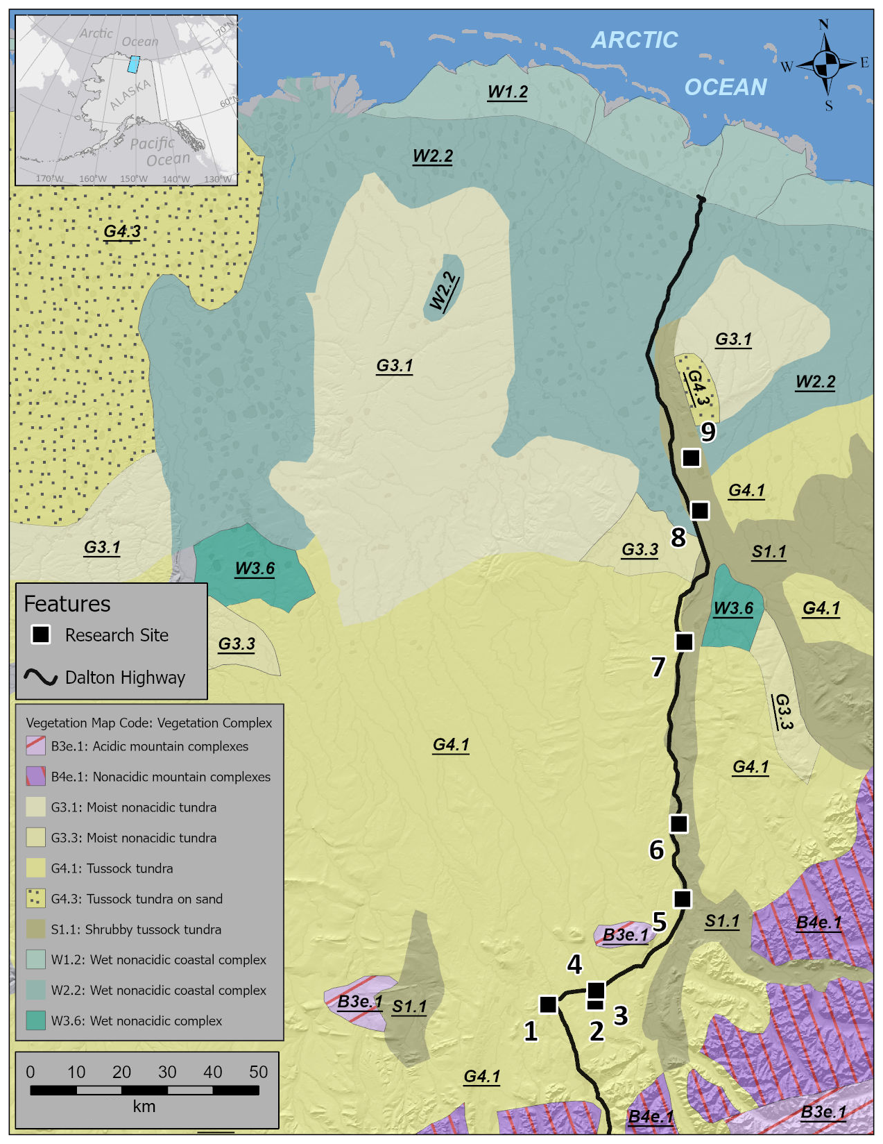
Figure A1The dominant vegetation type in the study region which depicts the main vegetation types where historical fires occurred. For details, see Fig. 1.
The AMS radiocarbon measurements at all sites are presented in Table B1a. The calibration of the radiocarbon dates and the construction of the age depth models were taken from the original publications and were performed with OxCal 4.4.4 software (Bronk Ramsey, 2009) and the IntCal13 or IntCa20 (Reimer et al., 2013, 2020) and post-bomb NH1 (Hua et al., 2022) calibration curves (visible in each figure insert). The Bayesian age-depth models were calculated by applying the P_Sequence function (parameters = 1 cm−1, and interpolation = 0.5 cm). BCE: before Common Era. CE: Common Era.
Table B1(a) AMS 14C measurements at nine investigated sites. pMC denotes modern 14C, post 1950 CE. (b) 210Pb dates at GaI and GaII (for details see Gałka et al., 2023).
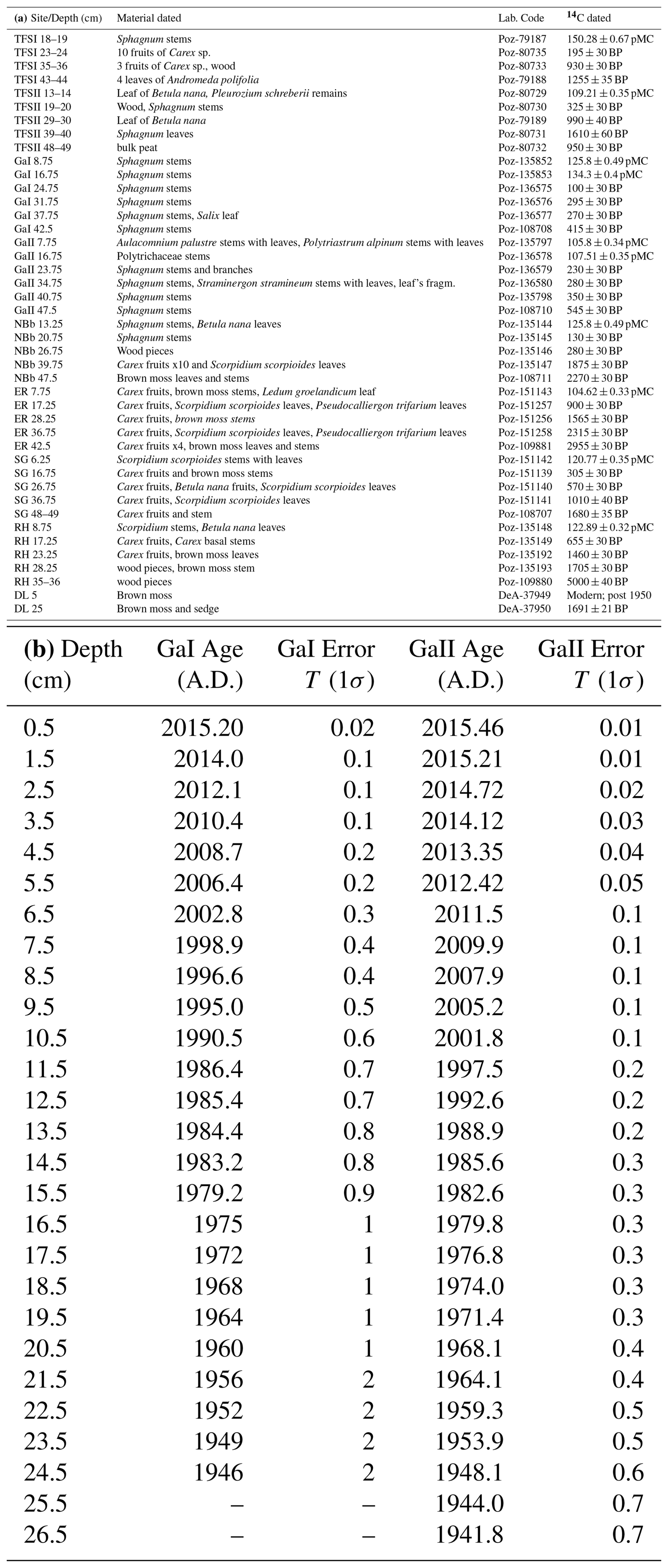
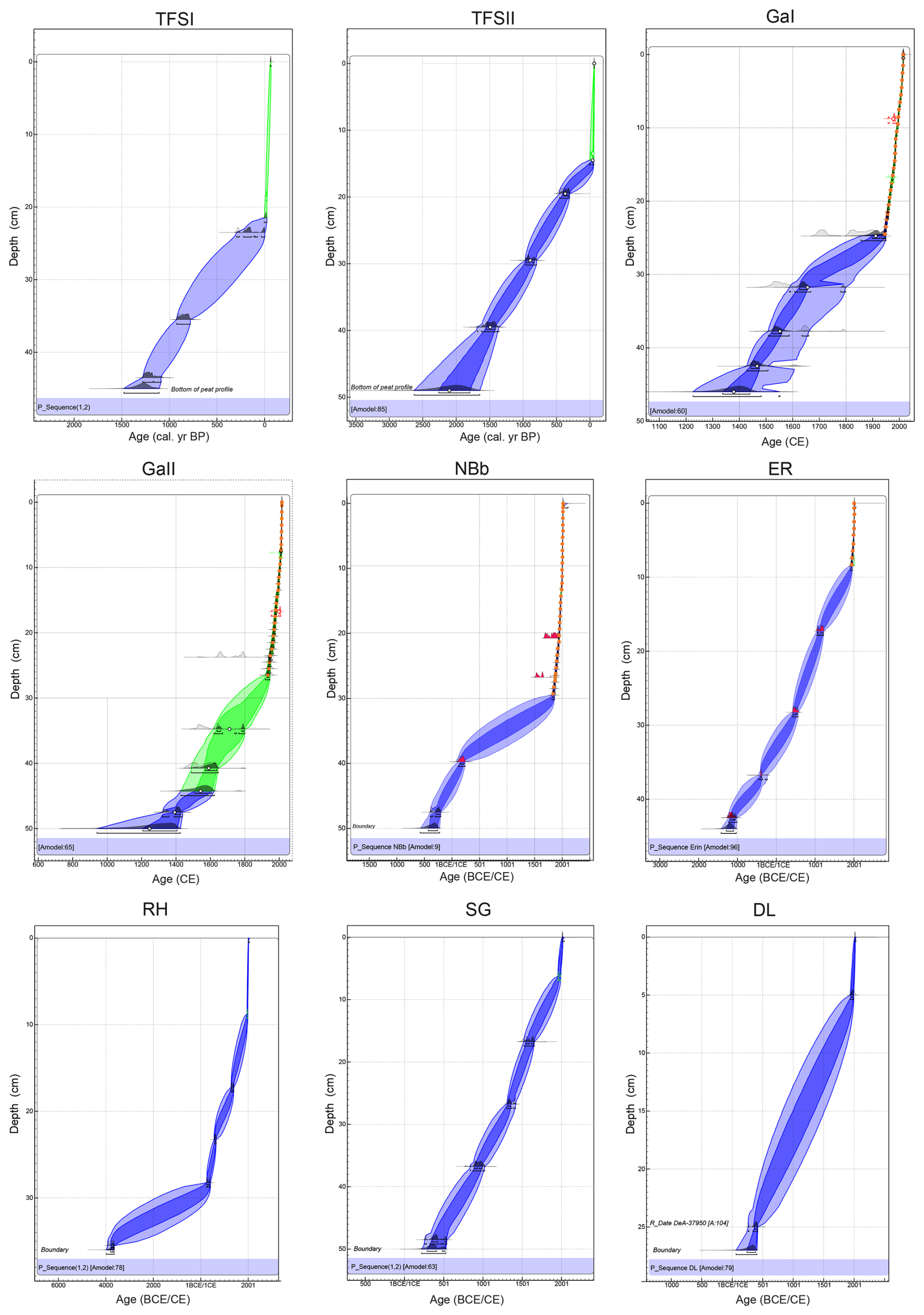
Figure B1Age depth model at TFSI and TFS II after Gałka et al. (2018); GaI and GaII after Gałka et al. (2023); NBb and ER after Gałka et al. (2025); and RH, SG, DL (this study). The y axis represents the depth (cm); the position of each radiocarbon measurement are shown inside the plot. The light, dark blue and green shaded areas represent uncertainty ranges in the age-depth model. The black or red histogram shows the possible age range of each measured sample. Orange circles indicate 210Pb measurements.
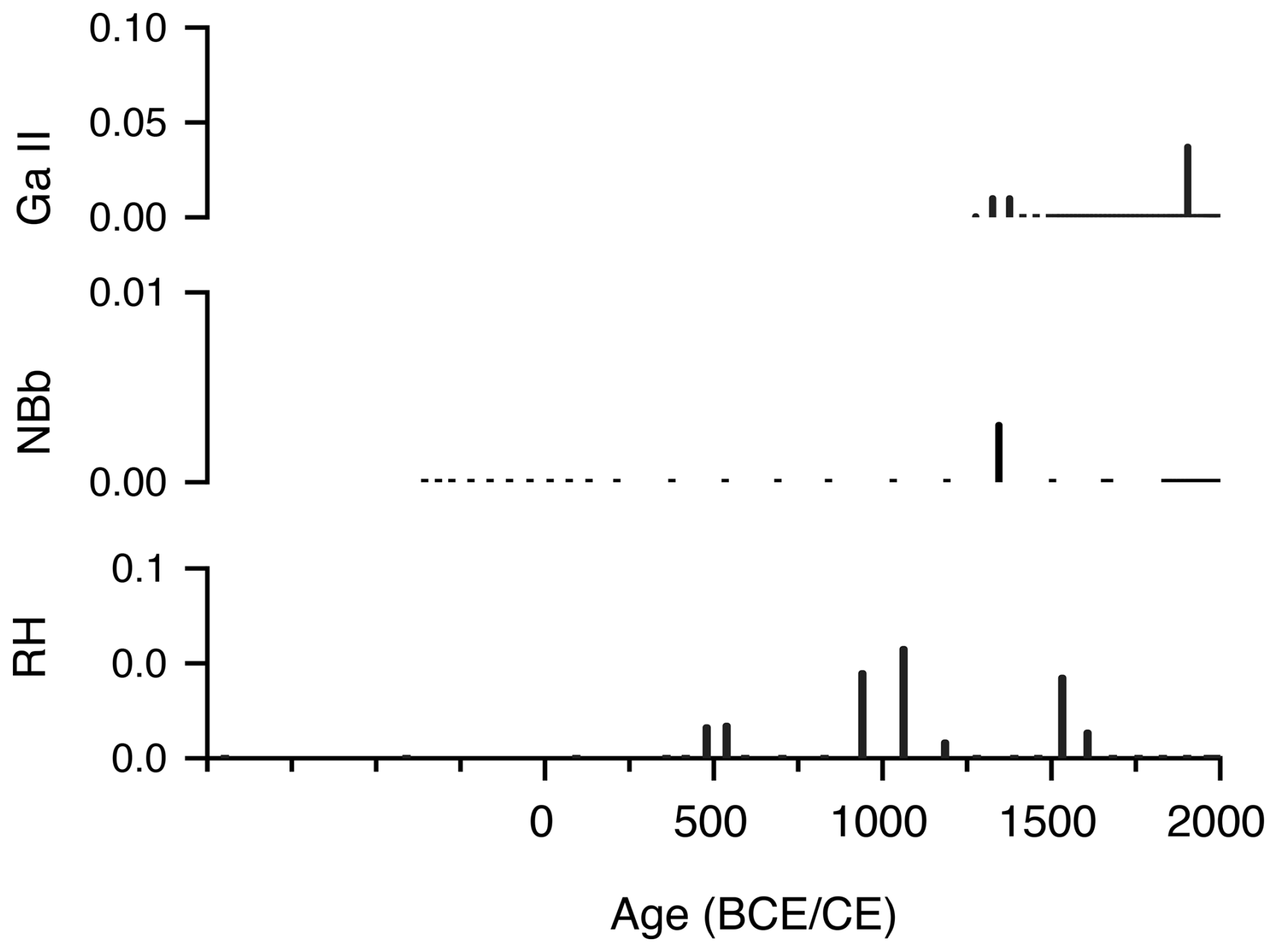
Figure C1Charcoal influx () of particles > 500 µm in the sequences with available counts size.
The datasets are available or current uploaded in Neotoma (https://doi.org/10.21233/3WXR-9P46, Galka, 2025a; https://doi.org/10.21233/AYTC-HK08, Galka, 2025b; https://doi.org/10.21233/YM1G-KC79, Galka, 2025c) and are also presented as Supplement to this paper.
Tables S1, S2, S3: Satellite-based information of fire names, coordinates, size, and distance from the Dalton Highway and charcoal sampling sites. The supplement related to this article is available online at https://doi.org/10.5194/bg-22-6651-2025-supplement.
AF and MG conceived study. AF, ACD, RF, GS, MG, performed the laboratory analysis. AF performed the numerical analysis and prepared the manuscript with contributions from MG. All authors contributed to review and editing.
The contact author has declared that none of the authors has any competing interests.
Publisher' note: Copernicus Publications remains neutral with regard to jurisdictional claims made in the text, published maps, institutional affiliations, or any other geographical representation in this paper. While Copernicus Publications makes every effort to include appropriate place names, the final responsibility lies with the authors. Views expressed in the text are those of the authors and do not necessarily reflect the views of the publisher.
We thank Liam Taylor for performing the testate amoeba analysis at TFS I and II. We greatly appreciate constructive criticism and suggestions from the editor (David McLangan), Ramesh Glückler, and an anonymous reviewer.
This research has been supported by the Narodowym Centrum Nauki (grant no. UMO-2019/35/B/ST10/00367) and the Deutsche Forschungsgemeinschaft (grant no. FE_1096/9) and.
This open-access publication was funded by Goethe University Frankfurt.
This paper was edited by David McLagan and reviewed by Ramesh Glückler and one anonymous referee.
Adolf, C., Wunderle, S., Colombaroli, D., Weber, H., Gobet, E., Heiri, O., van Leeuwen, J. F. N., Bigler, C., Connor, S. E., Gałka, M., La Mantia, T., and Tinner, W.: The sedimentary and remote sensing reflection of biomass burning in Europe, Glob. Ecol. Biogeogr., 27, 199–212, https://doi.org/10.1111/geb.12682, 2018.
Archibald, S., Lehmann, C. E. R., Gómez-Dans, J. L., and Bradstock, R. A.: Defining pyromes and global syndromes of fire regimes, Proc. Natl. Acad. Sci. USA, 110, 6442–6447, https://doi.org/10.1073/pnas.1211466110, 2013.
Barhoumi, C., Peyron, O., Joannin, S., Subetto, D., Kryshen, A., Drobyshev, I., Girardin, M. P., Brossier, B., Paradis, L., Pastor, T., and Alleaume, S.: Gradually increasing forest fire activity during the Holocene in the northern Ural region (Komi Republic, Russia), Holocene, 29, 906–920, https://doi.org/10.1177/0959683619865593, 2019.
Blarquez, O., Vannière, B., Marlon, J. R., Daniau, A.-L., Power, M. J., Brewer, S., and Bartlein, P. J.: Paleofire – An R package to analyse sedimentary charcoal records from the Global Charcoal Database to reconstruct past biomass burning, Comput. Geosci., 72, 255–261, https://doi.org/10.1016/j.cageo.2014.07.020, 2014.
Bronk Ramsey, C.: Bayesian analysis of radiocarbon dates, Radiocarbon, 51, 337–-360, https://doi.org/10.1017/S0033822200033865, 2009.
Chipman, M. L. and Hu, F. S.: Linkages among climate, fire, and thermoerosion in Alaskan tundra over the past three millennia, J. Geophys. Res. Biogeosci., 122, 3362–-3377, https://doi.org/10.1002/2017JG004002, 2017.
Chipman, M. L., Hudspith, V., Higuera, P. E., Duffy, P. A., Kelly, R., Oswald, W. W., and Hu, F. S.: Spatiotemporal patterns of tundra fires: late-Quaternary charcoal records from Alaska, Biogeosciences, 12, 4017–4027, https://doi.org/10.5194/bg-12-4017-2015, 2015.
Cleary, K. G., Xia, Z., and Yu, Z.: The Growth and Carbon Sink of Tundra Peat Patches in Arctic Alaska, J. Geophys. Res.-Biogeo., 129, e2023JG007890, https://doi.org/10.1029/2023JG007890, 2024.
Conedera, M., Tinner, W., Neff, C., Meurer, M., Dickens, A. F., and Krebs, P.: Reconstructing past fire regimes: methods, applications, and relevance to fire management and conservation, Quat. Sci. Rev.,, 28, 555–576, https://doi.org/10.1016/j.quascirev.2008.11.005, 2009.
Cox, C. J., Stone, R. S., Douglas, D. C., Stanitski, D. M., Divoky, G. J., Dutton, G. S., Sweeney, C., George, J. C., and Longenecker, D. U.: Drivers and environmental responses to the changing annual snow cycle of northern Alaska, Bull. Am. Meteorol. Soc., 98, 2559–2577, https://doi.org/10.1175/BAMS-D-16-0201.1, 2017.
de Groot, W. J. and Wein, R. W.: Betula glandulosa Michx. response to burning and postfire growth temperature and implications of climate change, Int. J. Wildland Fire, 9, 51–64, https://doi.org/10.1071/WF03048, 1999.
de Groot, W. J., Cantin, A. S., Flannigan, M. D., Soja, A. J., Gowman, L. M., and Newbery, A.: A comparison of Canadian and Russian boreal forest fire regimes, For. Ecol. Manag., 294, 23–34, https://doi.org/10.1016/j.foreco.2012.07.033, 2013.
Descals, A., Verger, A., Vilar, L., López-García, M. J., Pettinari, M. L., Tansey, K., and Pons, X.: Unprecedented fire activity above the Arctic Circle linked to rising temperatures, Science, 378, 532–537, https://doi.org/10.1126/science.abn9768, 2022.
Environmental Data Center Team: Meteorological monitoring program at Toolik, Alaska. Toolik Field Station, Institute of Arctic Biology, University of Alaska Fairbanks, Fairbanks, AK 99775, https://www.uaf.edu/toolik/edc/monitoring/abiotic/met-data-query.php (last access: 18 October 2025), 2024.
Feurdean, A.: Experimental production of charcoal morphologies to discriminate fuel source and fire type: an example from Siberian taiga, Biogeosciences, 18, 3805–3821, https://doi.org/10.5194/bg-18-3805-2021, 2021.
Feurdean, A., Veski, S., Florescu, G., Vannière, B., Pfeiffer, M., O'Hara, R. B., Stivrins, N., Amon, L., Heinsalu, A., Vassiljev, J., and Hickler, T.: Broadleaf deciduous forest counterbalanced the direct effect of climate on Holocene fire regime in hemiboreal/boreal region (NE Europe), Quat. Sci. Rev., 169, 378–390, https://doi.org/10.1016/j.quascirev.2017.05.024, 2017.
Feurdean, A., Florescu, G., Tanţău, I., Vannière, B., Diaconu, A. C., Pfeiffer, M., Warren, D., Hutchinson, S. M., Gorina, N., Gałka, M., and Kirpotin, S.: Recent fire regime in the southern boreal forests of western Siberia is unprecedented in the last five millennia, Quat. Sci. Rev.,, 244, 106495, https://doi.org/10.1016/j.quascirev.2020.106495, 2020.
Feurdean, A., Diaconu, A.-C., Pfeiffer, M., Gałka, M., Hutchinson, S. M., Butiseaca, G., Gorina, N., Tonkov, S., Niamir, A., Tantau, I., Zhang, H., and Kirpotin, S.: Holocene wildfire regimes in western Siberia: interaction between peatland moisture conditions and the composition of plant functional types, Clim. Past, 18, 1255–1274, https://doi.org/10.5194/cp-18-1255-2022, 2022.
Frank-DePue, L. and Chipman, M. L.: Late Holocene tundra fires and linkages to climate and vegetation in Northern Alaska, Arctic Science, 11, 1–14, https://doi.org/10.1139/as-2025-0009, 2025.
Galka, M.: NBb pollen dataset (Version 1.0), Neotoma Paleoecology Database [data set], https://doi.org/10.21233/3WXR-9P46, 2025a.
Galka, M.: GaI pollen dataset (Version 1.0), Neotoma Paleoecology Database [data set], https://doi.org/10.21233/AYTC-HK08, 2025b.
Galka, M.: GaII pollen dataset (Version 1.0), Neotoma Paleoecology Database [data set], https://doi.org/10.21233/YM1G-KC79, 2025c.
Gałka, M., Swindles, G. T., Szal, M., Fulweber, R., and Feurdean, A.: Response of plant communities to climate change during the late Holocene: palaeoecological insights from peatlands in the Alaskan Arctic, Ecol. Indic., 85, 525–536, https://doi.org/10.1016/j.ecolind.2017.10.062, 2018.
Gałka, M., Diaconu, A. C., Cwanek, A., Baranov, V. A., Feurdean, A., Loisel, J., Novenko, E. Y., and De Klerk, P.: Climate-induced hydrological fluctuations shape Arctic Alaskan peatland plant communities, Sci. Total Environ., 905, 167381, https://doi.org/10.1016/j.scitotenv.2023.167381, 2023.
Gałka, M., Knorr, K.-H., Obremska, M., Diaconu, A.-C., Hedenäs, L., Cwanek, A., Stivrins, N., Swindles, G. T., Sala, D., Łokas, E., and Feurdean, A.: The role of climate and hydrology fluctuations in shaping Northern Alaska plant community over the last three millennia, Prog. Phys. Geogr. Earth Environ., 49, 421–-442, https://doi.org/10.1177/03091333251353696, 2025.
Hamilton, T. D.: Late Cenozoic glaciation of the central Brooks Range, in: Glaciation in Alaska: The Geologic Record, edited by: Hamilton, T. D., Reed, K. M., and Thorson, R. M., Alaska Geological Society, Fairbanks, AK, 9–49, 1986.
Higuera, P. E., Sprugel, D. G., and Brubaker, L. B.: Reconstructing fire regimes with charcoal from small-hollow sediments: a calibration with tree-ring records of fire, Holocene, 15, 238–251, https://doi.org/10.1191/0959683605hl789rp, 2005.
Higuera, P. E., Peters, M. E., Brubaker, L. B., and Gavin, D. G.: Understanding the origin and analysis of sediment-charcoal records with a simulation model, Quat. Sci. Rev., 26, 1790–1809, https://doi.org/10.1016/j.quascirev.2007.03.010, 2007.
Higuera, P. E., Brubaker, L. B., Anderson, P. M., Brown, T. A., Kennedy, A. T., and Hu, F. S.: Frequent fires in ancient shrub tundra: implications of paleorecords for arctic environmental change, PLoS ONE, 3, e1744, https://doi.org/10.1371/journal.pone.0001744, 2008.
Higuera, P. E., Chipman, M. L., Barnes, J. L., Urban, M. A., and Hu, F. S.: Variability of tundra fire regimes in Arctic Alaska: millennial-scale patterns and ecological implications, Ecol. Appl., 21, 3211–3226, https://doi.org/10.1890/11-0387.1, 2011.
Hoecker, T. K., Higuera, P. E., Kelly, R., and Hu, F. S.: Arctic and boreal paleofire records reveal drivers of fire activity and departures from Holocene variability, Ecology, 101, e03096, https://doi.org/10.1002/ecy.3096, 2020.
Hu, F. S., Higuera, P. E., Walsh, J. E., Chapman, W. L., Duffy, P. A., Brubaker, L. B., and Chipman, M. L.: Tundra burning in Alaska: Linkages to climatic change and sea ice retreat, J. Geophys. Res.-Biogeo., 115, G04002, https://doi.org/10.1029/2009JG001270, 2010.
Hu, F. S., Higuera, P. E., Duffy, P. A., Chipman, M. L., Rocha, A. V., Young, A. M., Kelly, R., and Dietze, M. C.: Arctic tundra fires: Natural variability and responses to climate change, Front. Ecol. Environ., 13, 369–377, https://doi.org/10.1890/150063, 2015.
Hua, Q., Turnbull, J. C., Santos, G. M., Rakowski, A. Z., Ancapichún, S., De Pol-Holz, R., Hammer, S., Lehman, S. J., Levin, I., Miller, J. B., Palmer, J. G., and Turney, C. S. M.: Atmospheric radiocarbon for the period 1950–-2019, Radiocarbon, 64, 723–-745, https://doi.org/10.1017/RDC.2021.95, 2022.
Kettridge, N., Turetsky, M., Sherwood, J. H., Thompson, D. K., Miller, C. A., Benscoter, B. W., Flannigan, M. D., Wotton, B. M., and Waddington, J. M.: Moderate drop in water table increases peatland vulnerability to post-fire regime shift, Sci. Rep., 5, 8063, https://doi.org/10.1038/srep08063, 2015.
Kuosmanen, N., Väliranta, M., Piilo, S., Tuittila, E.-S., Oksanen, P., and Wallenius, T.: Repeated fires in forested peatlands in sporadic permafrost zone in Western Canada, Environmental Research Letters, 18, 094051, https://doi.org/10.1088/1748-9326/acf05b, 2023.
Loisel, J., Gallego-Sala, A. V., Amesbury, M. J., Magnan, G., Anshari, G., Beilman, D. W., Benavides, J. C., Blewett, J., Camill, P., Charman, D. J., Chawchai, S., Hedgpeth, A., Kleinen, T., Korhola, A., Large, D., Mansilla, C. A., Müller, J., van Bellen, S., West, J. B., Yu, Z., Bubier, J. L., Garneau, M., Moore, T., Sannel, A. B. K., Page, S., Väliranta, M., Bechtold, M., Brovkin, V., Cole, L. E. S., Chanton, J. P., Christensen, T. R., Davies, M. A., De Vleeschouwer, F., Finkelstein, S. A., Frolking, S., Gałka, M., Gandois, L., Girkin, N., Harris, L. I., Heinemeyer, A., Hoyt, A. M., Jones, M. C., Joos, F., Juutinen, S., Kaiser, K., Lacourse, T., Lamentowicz, M., Larmola, T., Leifeld, J., Lohila, A., Milner, A. M., Minkkinen, K., Moss, P., Naafs, B. D. A., Nichols, J., O’Donnell, J., Payne, R., Philben, M., Piilo, S., Quillet, A., Ratnayake, A. S., Roland, T. P., Sjögersten, S., Sonnentag, O., Swindles, G. T., Swinnen, W., Talbot, J., Treat, C., Valach, A. C., and Wu, J.: Expert assessment of future vulnerability of the global peatland carbon sink, Nat. Clim. Change, 11, 70–77, https://doi.org/10.1038/s41558-020-00944-0, 2021.
Magnan, G. M., Lavoie, M., and Payette, S.: Impact of fire on long-term vegetation dynamics of ombrotrophic peatlands in northwestern Quebec, Canada, Quat. Res., 77, 110–121, https://doi.org/10.1016/j.yqres.2011.10.006, 2012.
Miller, E. A., Jones, B. M., Baughman, C. A., Jandt, R. R., Jenkins, J. L., and Yokel, D. A.: Unrecorded tundra fires of the Arctic Slope, Alaska, USA, Fire, 6, 101, https://doi.org/10.3390/fire6030101, 2023.
Pereboom, E. M., Vachula, R. S., Huang, Y., and Russell, J.: The morphology of experimentally produced charcoal distinguishes fuel types in the Arctic tundra, Holocene, 7, 1–6, https://doi.org/10.1177/0959683620908629, 2020.
Raynolds, M. A., Walker, D. A., and Maier, H. A.: Alaska Arctic Tundra Vegetation Map, Scale 1:4,000,000, Conservation of Arctic Flora and Fauna (CAFF) Map No. 2, U.S. Fish and Wildlife Service, Anchorage, Alaska, https://arcticatlas.geobotany.org/catalog/dataset/alaska-arctic-tundra-vegetation-map-raynolds-et-al-2006 (last access: 30 October 2025), 2006.
Reimer, P. J., Bard, E., Bayliss, A., Beck, J. W., Blackwell, P. G., Ramsey, C. B., Buck, C. E., Cheng, H., Edwards, R. L., Friedrich, M., Grootes, P. M., Guilderson, T. P., Haflidason, H., Hajdas, I., Hatté, C., Heaton, T. J., Hoffmann, D. L., Hogg, A. G., Hughen, K. A., Kaiser, K. F., Kromer, B., Manning, S. W., Niu, M., Reimer, R. W., Richards, D. A., Scott, E. M., Southern, J. R., Staff, R. A., Turney, C. S. M., and van der Plicht, J.: IntCal13 and Marine13 radiocarbon age calibration curves 0–50,000 years cal BP, Radiocarbon, 55, 1869–1887, https://doi.org/10.2458/azu_js_rc.55.16947, 2013.
Reimer, P. J., Austin, W. E. N., Bard, E., Bayliss, A., Blackwell, P. G., Bronk Ramsey, C., Butzin, M., Cheng, H., Edwards, R. L., Friedrich, M., Grootes, P. M., Guilderson, T. P., Hajdas, I., Heaton, T. J., Hogg, A. G., Hughen, K. A., Kromer, B., Manning, S. W., Muscheler, R., Palmer, J. G., Pearson, C., van der Plicht, J., Reimer, R. W., Richards, D. A., Scott, E. M., Southon, J. R., Turney, C. S. M., Wacker, L., Adolphi, F., Büntgen, U., Capano, M., Fahrni, S. M., Friedrich, R., Köhler, P., Kudsk, S., Miyake, F., Olsen, J., Reinig, F., Sakamoto, M., Sookdeo, A., and Talamo, S.: The IntCal20 Northern Hemisphere radiocarbon age calibration curve (0–55 cal ka BP), Radiocarbon, 62, 725–757, https://doi.org/10.1017/RDC.2020.41, 2020.
Remy, C. C., Fouquemberg, C., Asselin, H., Andrieux, B., Magnan, G., Brossier, B., Grondin, P., Bergeron, Y., Talon, B., Girardin, M. P., and Blarquez, O.: Guidelines for the use and interpretation of palaeofire reconstructions based on various archives and proxies, Quat. Sci. Rev.,, 193, 312–322, https://doi.org/10.1016/j.quascirev.2018.06.010, 2018.
Sayedi, S. S., Abbott, B. W., Vannière, B., Leys, B., Colombaroli, D., Gil Romera, G., Słowiński, M., Aleman, J. C., Blarquez, O., Feurdean, A., and Brown, K.: Assessing changes in global fire regimes, Fire Ecol., 20, 1–22, https://doi.org/10.1186/s42408-023-00237-9, 2024.
Scholten, R. C., Jandt, R., Miller, E. A., Rogers, B. M., and Veraverbeke, S.: Overwintering fires in boreal forests, Nature, 593, 399–404, https://doi.org/10.1038/s41586-021-03437-y, 2021.
Scholten, R. C., Veraverbeke, S., and Chen, Y.: Spatial variability in Arctic–boreal fire regimes influenced by environmental and human factors, Nat. Geosci., 17, 866–873, https://doi.org/10.1038/s41561-024-01505-2, 2024.
Sim, T. G., Swindles, G. T., Morris, P. J., Baird, A. J., Gallego-Sala, A. V., Wang, Y., Blaauw, M., Camill, P., Garneau, M., Hardiman, M., and Loisel, J.: Regional variability in peatland burning at mid- to high-latitudes during the Holocene, Quat. Sci. Rev., 305, 108020, https://doi.org/10.1016/j.quascirev.2023.108020, 2023.
Stivrins, N., Aakala, T., Ilvonen, L., Pasanen, L., Kuuluvainen, T., Vasander, H., Gałka, M., Disbrey, H. R., Liepins, J., Holmström, L., and Seppä, H.: Integrating fire-scar, charcoal and fungal spore data to study fire events in the boreal forest of northern Europe, Holocene, 29, 1480–1490, https://doi.org/10.1177/0959683619854524, 2019.
Swindles, G. T., Morris, P. J., Mullan, D. J., Payne, R. J., Roland, T. P., Amesbury, M. J., Lamentowicz, M., Turner, T. E., Gallego-Sala, A., Sim, T., and Barr, I. D.: Widespread drying of European peatlands in recent centuries, Nat. Geosci., 12, 922–928, https://doi.org/10.1038/s41561-019-0462-z, 2019.
Taylor, L. S., Swindles, G. T., Morris, P. J., Gałka, M., and Green, S. M.: Evidence for ecosystem state shifts in Alaskan continuous permafrost peatlands in response to recent warming, Quat. Sci. Rev., 207, 134–144, https://doi.org/10.1016/j.quascirev.2019.02.001, 2019.
Turetsky, M., Benscoter, B., Page, S., Rein, G., van der Werf, G. R., and Watts, A.: Global vulnerability of peatlands to fire and carbon loss, Nat. Geosci., 8, 11–14, https://doi.org/10.1038/ngeo2325, 2015.
Vachula, R. S. and Rehn, E.: Modeled dispersal patterns for wood and grass charcoal are different: implications for paleofire reconstruction, Holocene, 33, 159–166, https://doi.org/10.1177/09596836221131708, 2023.
Vachula, R. S., Sae-Lim, J., and Russell, J. M.: Sedimentary charcoal proxy records of fire in Alaskan tundra ecosystems, Palaeogeography Palaeoclimatology Palaeoecology, 1, 541, 109564, https://doi.org/10.1016/j.palaeo.2019.109564, 2020.
Walker, D. A., Raynolds, M. K., Daniëls, F. J. A., Einarsson, E., Elvebakk, A., Gould, W. A., Katenin, A. E., Kholod, S. S., Markon, C. J., Melnikov, E. S., Moskalenko, N. G., Talbot, S. S., Yurtsev, B. A., Bliss, L. C., Edlund, S. A., Zoltai, S. C., Wilhelm, M., Bay, C., Gudjonsson, G., Ananjeva, G. V., Drozdov, D. S., Konchenko, L. A., Korostelev, Y. V., Ponomareva, O. E., Matveyeva, N. V., Safranova, I. N., Shelkunova, R., Polezhaev, A. N., Johansen, B. E., Maier, H. A., Murray, D. F., Fleming, M. D., Trahan, N. G., Charron, T. M., Lauritzen, S. M., and Vairin, B. A.: The Circumpolar Arctic vegetation map, J. Veg. Sci., 16, 267–282, https://doi.org/10.1111/j.1654-1103.2005.tb02365.x, 2005.
Walker, M. D., Walker, D. A., and Auerbach, N. A.: Plant communities of a tussock tundra landscape in the Brooks Range Foothills, Alaska, J. Veg. Sci., 5, 843–866, https://doi.org/10.2307/3236198, 1994.
Whitman, E., Parisien, M.-A., Thompson, D. K., and Flannigan, M. D.: Topoedaphic and forest controls on post-fire vegetation assemblies are modified by fire history and burn severity in the northwestern Canadian boreal forest, Forests, 9, 151, https://doi.org/10.3390/f9030151, 2018.
Whitman, E., Parisien, M.-A., Thompson, D. K., and Flannigan, M. D.: Short-interval wildfire and drought overwhelm boreal forest resilience, Sci. Rep., 9, 16519, https://doi.org/10.1038/s41598-019-55036-7, 2019.
- Abstract
- Introduction
- Geographical location and sites selection
- Material and methods
- Results
- Discussion
- Conclusion
- Appendix A: The dominant vegetation type in the study region
- Appendix B: Chronology
- Appendix C: Charcoal influx of particles larger then > 500 µm
- Data availability
- Author contributions
- Competing interests
- Disclaimer
- Acknowledgements
- Financial support
- Review statement
- References
- Supplement