
Articles | Volume 23, issue 20
https://doi.org/10.5194/bg-23-7253-2026
© Author(s) 2026. This work is distributed under
the Creative Commons Attribution 4.0 License.
the Creative Commons Attribution 4.0 License.
https://doi.org/10.5194/bg-23-7253-2026
© Author(s) 2026. This work is distributed under
the Creative Commons Attribution 4.0 License.
the Creative Commons Attribution 4.0 License.
Research article
| 
16 Oct 2026
Research article |
| 16 Oct 2026
| 16 Oct 2026
Tracking crop evapotranspiration and water stress across seasons using multi-sensor UAV observations
Jordan Steven Bates
Earth Observation and Ecosystem Modeling (EOSystM) Laboratory, SPHERES Research Unit, University of Liege, Liege, Belgium
Institute of Bio- and Geosciences: Agrosphere (IBG-3), Forschungszentrum Jülich GmbH, 52428 Jülich, Germany

Institute of Bio- and Geosciences: Agrosphere (IBG-3), Forschungszentrum Jülich GmbH, 52428 Jülich, Germany
Harry Vereecken
Institute of Bio- and Geosciences: Agrosphere (IBG-3), Forschungszentrum Jülich GmbH, 52428 Jülich, Germany
François Jonard
Earth Observation and Ecosystem Modeling (EOSystM) Laboratory, SPHERES Research Unit, University of Liege, Liege, Belgium
Related authors
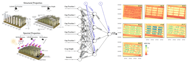
Jordan Steven Bates, Carsten Montzka, Rajina Bajracharya, Harry Vereecken, and François Jonard
Biogeosciences, 23, 6179–6210, https://doi.org/10.5194/bg-23-6179-2026, https://doi.org/10.5194/bg-23-6179-2026, 2026
Short summary
Short summary
This study compared drone-based laser, multispectral, and thermal sensors for estimating winter wheat biomass. Combining laser-derived crop structure and signal intensity improved predictions compared with crop height or multispectral data alone, while combining multispectral and thermal data with laser-derived features provided additional information during particular growth stages. The results highlight the potential of underutilized laser-derived features for crop biomass monitoring.
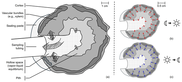
Youri Rothfuss, Samuel Le Gall, Nicolas Brüggemann, Sharmin Jahan, Mathieu Javaux, Julian Klaus, Harry Vereecken, and Dagmar van Dusschoten
Hydrol. Earth Syst. Sci., 30, 6095–6114, https://doi.org/10.5194/hess-30-6095-2026, https://doi.org/10.5194/hess-30-6095-2026, 2026
Short summary
Short summary
How plants cope with water stress is relevant when studying plant water sources in soil. We associated two techniques for measuring the content in water stable isotopes in the stem of sunflower plants and for locating where they take up water in a non-destructive manner. We highlight the role of stem water as a source of water to transpiration flux.
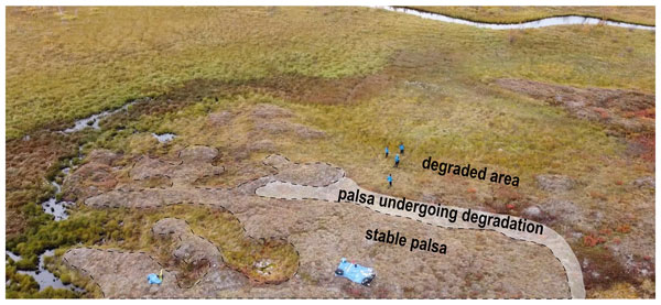
Maxime Thomas, Thomas Moenaert, Julien Radoux, Baptiste Delhez, Eléonore du Bois d'Aische, Maëlle Villani, Catherine Hirst, Erik Lundin, François Jonard, Sébastien Lambot, Kristof Van Oost, Veerle Vanacker, Matthias B. Siewert, Carl-Magnus Mörth, Michael W. Palace, Ruth K. Varner, Franklin B. Sullivan, Christina Herrick, and Sophie Opfergelt
The Cryosphere, 20, 5271–5301, https://doi.org/10.5194/tc-20-5271-2026, https://doi.org/10.5194/tc-20-5271-2026, 2026
Short summary
Short summary
This study examines the rate of permafrost degradation, in the form of the transition from intact well-drained palsa to fully thawed and inundated fen at the Stordalen mire, Abisko, Sweden. Across the 14 hectares of the palsa mire, we demonstrate a 10-fold acceleration of the degradation in 2019–2021 compared to previous periods (1970–2014) which might lead to a pool of 12 × 10³ kg of organic carbon exposed annually for the topsoil (23 cm depth).
Nunzio Romano, Harry Vereecken, Heye R. Bogena, Giorgio Cassiani, Matteo Censini, Giovanna Armiento, Marco Proposito, Lorenzo De Silvestri, Eyal Ben Dor, Nicolas Francos, Christian Massari, János Mészáros, Tünde Takáts, Caterina Mazzitelli, Benedetto Sica, Ugo Lazzaro, and Paolo Nasta
Earth Syst. Sci. Data Discuss., https://doi.org/10.5194/essd-2026-725, https://doi.org/10.5194/essd-2026-725, 2026
Preprint under review for ESSD
Short summary
Short summary
Understanding how climate and land-use change affect water resources requires observations that connect processes from soils and vegetation to groundwater and streams. The Alento dataset is presented that integrates environmental monitoring with targeted field observations across multiple Critical Zone components and scales. The dataset offers a distinctive resource for studying water storage and movement, evaluating environmental models, and improving understanding of water-limited regions.
Jordan Steven Bates, Carsten Montzka, Rajina Bajracharya, Harry Vereecken, and François Jonard
Biogeosciences, 23, 6179–6210, https://doi.org/10.5194/bg-23-6179-2026, https://doi.org/10.5194/bg-23-6179-2026, 2026
Short summary
Short summary
This study compared drone-based laser, multispectral, and thermal sensors for estimating winter wheat biomass. Combining laser-derived crop structure and signal intensity improved predictions compared with crop height or multispectral data alone, while combining multispectral and thermal data with laser-derived features provided additional information during particular growth stages. The results highlight the potential of underutilized laser-derived features for crop biomass monitoring.
Matthias Cuntz, Stephan Thober, Anne Verhoef, Yijian Zeng, Aaron Boone, Agnès Ducharne, Sujan Koirala, David M. Lawrence, Philipp de Vrese, Carsten Montzka, Sonia I. Seneviratne, Harry Vereecken, Dani Or, Salma Tafasca, Naoki Mizukami, Rich Ellis, Patrick C. McGuire, and Lukas Gudmundsson
EGUsphere, https://doi.org/10.5194/egusphere-2026-4223, https://doi.org/10.5194/egusphere-2026-4223, 2026
Preprint archived
Short summary
Short summary
Land surface models (LSMs) are essential tools to analyze future climate change. Here we pushed state-of-the-art LSMs out of their comfort zone revealing hidden connections between processes encoded into the models. The LSMs reacted differently due to complex, sometimes counter-intuitive interactions of different water fluxes. We identified surface runoff and soil evaporation as the two main reasons behind model differences, which should be improved by using more mechanistic descriptions.
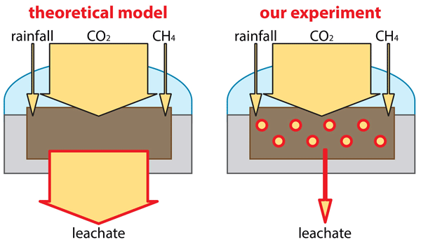
Francois Rineau, Alexander H. Frank, Jannis Groh, Kristof Grosjean, Arnaud Legout, Daniil I. Kolokolov, Michel Mench, Maria Moreno-Druet, Benoît Pollier, Virmantas Povilaitis, Johanna Pausch, Thomas Puetz, Tjalling Rooks, Peter Schröder, Wieslaw Szulc, Beata Rutkowska, Xander Swinnen, Sofie Thijs, Harry Vereecken, Janna V. Veselovskaya, Mwahija Zubery, Renaldas Žydelis, and Evelin Loit
Biogeosciences, 23, 2261–2276, https://doi.org/10.5194/bg-23-2261-2026, https://doi.org/10.5194/bg-23-2261-2026, 2026
Short summary
Short summary
Enhanced weathering can significantly slow climate change by capturing CO2 and converting it into stable bicarbonate. In study, this method removed up to 1.5 tons of carbon per hectare in a single growing season. We had however very little evidence of bicarbonate formation. Our findings show that enhanced weathering facilitated instead carbon accrual via not only carbonate precipitation but also enhanced biogeochemical activities promoting additional carbon storage.
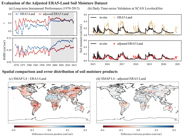
Wenhong Wang, Shiao Feng, Yonggen Zhang, Zhongwang Wei, Jianzhi Dong, Lutz Weihermüller, Cong-Qiang Liu, and Harry Vereecken
Earth Syst. Sci. Data, 18, 1061–1088, https://doi.org/10.5194/essd-18-1061-2026, https://doi.org/10.5194/essd-18-1061-2026, 2026
Short summary
Short summary
Current soil moisture data often suffers from gaps or errors. We combined the long-term coverage of ERA5-Land with the high accuracy of SMAP (Soil Moisture Active Passive) satellites to create a corrected global moisture dataset spanning 1950–2025. Validated against 3.8 million ground measurements, our product reduces errors by ~ 25 % in the modern period (2015–2020) and maintains ~ 20 % improvement historically (1960–2015). This reliable, daily 75-year record is essential for monitoring long-term climate trends and droughts.
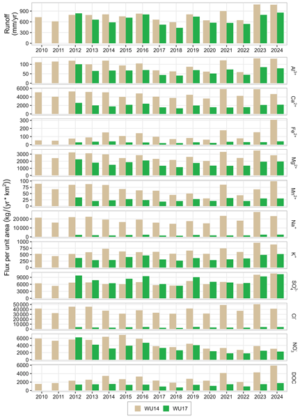
Heye R. Bogena, Frank Herrmann, Andreas Lücke, Thomas Pütz, and Harry Vereecken
Earth Syst. Sci. Data, 17, 6965–6992, https://doi.org/10.5194/essd-17-6965-2025, https://doi.org/10.5194/essd-17-6965-2025, 2025
Short summary
Short summary
The Wüstebach catchment, which is part of the German TERENO (Terrestrial Environmental Observatories) network, was partially deforested in 2013 to promote natural forest regrowth. This data paper provides 16 years of hourly concentrations and fluxes of 11 solutes and runoff rates (2010–2024) from two runoff gauging stations, one affected by deforestation and one not, illustrating forest-management effects on solute transport processes at the catchment scale.
Joschka Neumann, Nicolas Brüggemann, Patrick Chaumet, Normen Hermes, Jan Huwer, Peter Kirchner, Werner Lesmeister, Wilhelm August Mertens, Thomas Pütz, Jörg Wolters, Harry Vereecken, and Ghaleb Natour
Geosci. Instrum. Method. Data Syst., 14, 353–377, https://doi.org/10.5194/gi-14-353-2025, https://doi.org/10.5194/gi-14-353-2025, 2025
Short summary
Short summary
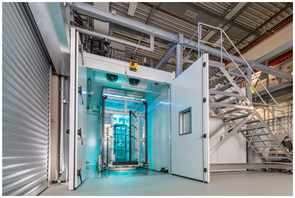
Climate change in combination with a steadily growing world population and a simultaneous decrease in agricultural land is one of the greatest global challenges facing mankind. In this context, Forschungszentrum Jülich established an "agricultural simulator" (AgraSim), which enables research into the effects of climate change on agricultural ecosystems and the optimization of agricultural cultivation and management strategies with the aid of combined experimental and numerical simulation.
Yanfei Li, Maud Henrion, Angus Moore, Sébastien Lambot, Sophie Opfergelt, Veerle Vanacker, François Jonard, and Kristof Van Oost
Biogeosciences, 22, 6369–6392, https://doi.org/10.5194/bg-22-6369-2025, https://doi.org/10.5194/bg-22-6369-2025, 2025
Short summary
Short summary
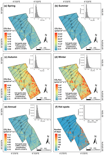
Combining Unmanned Aerial Vehicle (UAV) remote sensing with in-situ monitoring provides high spatial-temporal insights into CO2 fluxes from temperate peatlands. Dynamic factors (soil temperature and moisture) are the primary drivers contributing to 29 % of the spatial and 43 % of the seasonal variation. UAVs are effective tools for mapping daily soil respiration. CO2 fluxes from hot spots & moments contribute 20 % and 30 % of total CO2 fluxes, despite representing only 10 % of the area and time.
Maud Henrion, Sophie Opfergelt, Maëlle Villani, Philippe Roux, Djim Verleene, Eléonore du Bois d'Aische, Maxime Thomas, Gilles Denis, Edward A. G. Schuur, François Jonard, Veerle Vanacker, Kristof Van Oost, and Sébastien Lambot
EGUsphere, https://doi.org/10.5194/egusphere-2025-4667, https://doi.org/10.5194/egusphere-2025-4667, 2025
Preprint archived
Short summary
Short summary
Taliks play an important role in permafrost degradation. This study used Ground-penetrating radar to map taliks in Alaska, focusing on water tracks. The method successfully detected taliks and determined their upper depth. These were more frequent, shallower, and thicker under water tracks. This study showed that water tracks are hotspots for talik formation, with major implications for winter water flow in permafrost landscapes.
Thomas Dethinne, Nicolas Ghilain, Christoph Kittel, Benjamin Lecart, Xavier Fettweis, and François Jonard
EGUsphere, https://doi.org/10.5194/egusphere-2025-3907, https://doi.org/10.5194/egusphere-2025-3907, 2025
Short summary
Short summary
This study replace standard vegetation input of a regional climate model with a satellite-based vegetation dataset to assess how vegetation influences climate during extreme events and to test the sensitivity of the model. The results show a non-linear sensitivity to vegetation, and using an observation-based vegetation input allows for a better representation of the extreme events, highlight the need for an advanced representation of vegetation in climate model to improve climate predictions.
Salar Saeed Dogar, Cosimo Brogi, Dave O'Leary, Ixchel M. Hernández-Ochoa, Marco Donat, Harry Vereecken, and Johan Alexander Huisman
SOIL, 11, 655–679, https://doi.org/10.5194/soil-11-655-2025, https://doi.org/10.5194/soil-11-655-2025, 2025
Short summary
Short summary
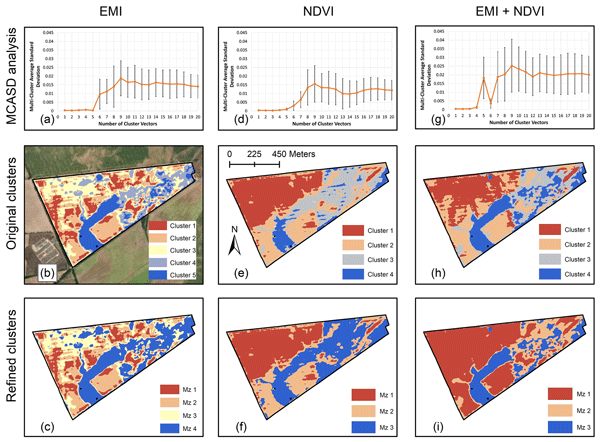
Farmers need precise information about their fields to use water, fertilizers, and other resources efficiently. This study combines underground soil data and satellite images to create detailed field maps using advanced machine learning. By testing different ways of processing data, we ensured a balanced and accurate approach. The results help farmers manage their land more effectively, leading to better harvests and more sustainable farming practices.

Anke Fluhrer, Martin J. Baur, María Piles, Bagher Bayat, Mehdi Rahmati, David Chaparro, Clémence Dubois, Florian M. Hellwig, Carsten Montzka, Angelika Kübert, Marlin M. Mueller, Isabel Augscheller, Francois Jonard, Konstantin Schellenberg, and Thomas Jagdhuber
Biogeosciences, 22, 3721–3746, https://doi.org/10.5194/bg-22-3721-2025, https://doi.org/10.5194/bg-22-3721-2025, 2025
Short summary
Short summary
This study compares established evapotranspiration products in central Europe and evaluates their multi-seasonal performance during wet and drought phases in 2017–2020 together with important soil–plant–atmosphere drivers. Results show that SEVIRI, ERA5-land, and GLEAM perform best compared to ICOS (Integrated Carbon Observation System) measurements. During moisture-limited drought years, ET (evapotranspiration) decreases due to decreasing soil moisture and increasing vapor pressure deficit, while in other years ET is mainly controlled by VPD (vapor pressure deficit).
Manuela S. Kaufmann, Anja Klotzsche, Jan van der Kruk, Anke Langen, Harry Vereecken, and Lutz Weihermüller
SOIL, 11, 267–285, https://doi.org/10.5194/soil-11-267-2025, https://doi.org/10.5194/soil-11-267-2025, 2025
Short summary
Short summary
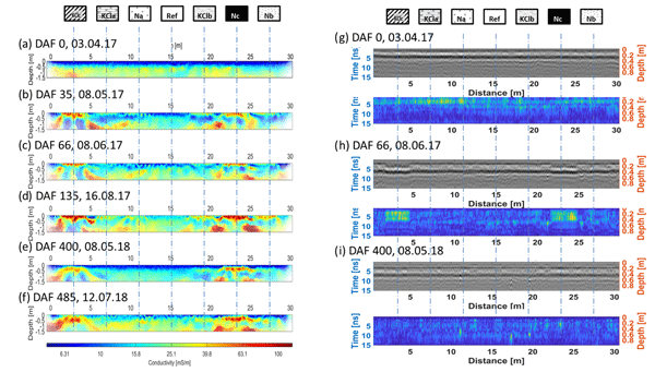
To use fertilizers more effectively, non-invasive geophysical methods can be used to understand nutrient distributions in the soil. We utilize, in a long-term field study, geophysical techniques to study soil properties and conditions under different fertilizer treatments. We compared the geophysical response with soil samples and soil sensor data. In particular, electromagnetic induction and electrical resistivity tomography were effective in monitoring changes in nitrate levels over time.
Bamidele Oloruntoba, Stefan Kollet, Carsten Montzka, Harry Vereecken, and Harrie-Jan Hendricks Franssen
Hydrol. Earth Syst. Sci., 29, 1659–1683, https://doi.org/10.5194/hess-29-1659-2025, https://doi.org/10.5194/hess-29-1659-2025, 2025
Short summary
Short summary
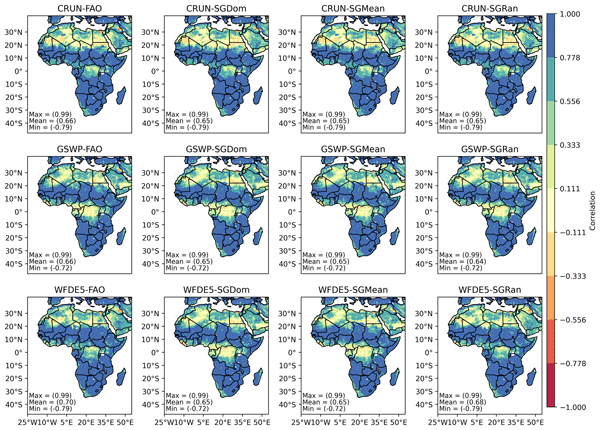
We studied how soil and weather data affect land model simulations over Africa. By combining soil data processed in different ways with weather data of varying time intervals, we found that weather inputs had a greater impact on water processes than soil data type. However, the way soil data were processed became crucial when paired with high-frequency weather inputs, showing that detailed weather data can improve local and regional predictions of how water moves and interacts with the land.
Paolo Nasta, Günter Blöschl, Heye R. Bogena, Steffen Zacharias, Roland Baatz, Gabriëlle De Lannoy, Karsten H. Jensen, Salvatore Manfreda, Laurent Pfister, Ana M. Tarquis, Ilja van Meerveld, Marc Voltz, Yijian Zeng, William Kustas, Xin Li, Harry Vereecken, and Nunzio Romano
Hydrol. Earth Syst. Sci., 29, 465–483, https://doi.org/10.5194/hess-29-465-2025, https://doi.org/10.5194/hess-29-465-2025, 2025
Short summary
Short summary
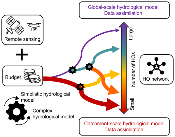
The Unsolved Problems in Hydrology (UPH) initiative has emphasized the need to establish networks of multi-decadal hydrological observatories to tackle catchment-scale challenges on a global scale. This opinion paper provocatively discusses two endmembers of possible future hydrological observatory (HO) networks for a given hypothesized community budget: a comprehensive set of moderately instrumented observatories or, alternatively, a small number of highly instrumented supersites.
Christian Poppe Terán, Bibi S. Naz, Harry Vereecken, Roland Baatz, Rosie A. Fisher, and Harrie-Jan Hendricks Franssen
Geosci. Model Dev., 18, 287–317, https://doi.org/10.5194/gmd-18-287-2025, https://doi.org/10.5194/gmd-18-287-2025, 2025
Short summary
Short summary
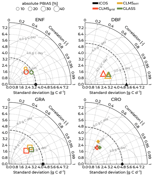
Carbon and water exchanges between the atmosphere and the land surface contribute to water resource availability and climate change mitigation. Land surface models, like the Community Land Model version 5 (CLM5), simulate these. This study finds that CLM5 and other data sets underestimate the magnitudes of and variability in carbon and water exchanges for the most abundant plant functional types compared to observations. It provides essential insights for further research into these processes.
Ying Zhao, Mehdi Rahmati, Harry Vereecken, and Dani Or
Hydrol. Earth Syst. Sci., 28, 4059–4063, https://doi.org/10.5194/hess-28-4059-2024, https://doi.org/10.5194/hess-28-4059-2024, 2024
Short summary
Short summary
Gao et al. (2023) question the importance of soil in hydrology, sparking debate. We acknowledge some valid points but critique their broad, unsubstantiated views on soil's role. Our response highlights three key areas: (1) the false divide between ecosystem-centric and soil-centric approaches, (2) the vital yet varied impact of soil properties, and (3) the call for a scale-aware framework. We aim to unify these perspectives, enhancing hydrology's comprehensive understanding.
Tobias Karl David Weber, Lutz Weihermüller, Attila Nemes, Michel Bechtold, Aurore Degré, Efstathios Diamantopoulos, Simone Fatichi, Vilim Filipović, Surya Gupta, Tobias L. Hohenbrink, Daniel R. Hirmas, Conrad Jackisch, Quirijn de Jong van Lier, John Koestel, Peter Lehmann, Toby R. Marthews, Budiman Minasny, Holger Pagel, Martine van der Ploeg, Shahab Aldin Shojaeezadeh, Simon Fiil Svane, Brigitta Szabó, Harry Vereecken, Anne Verhoef, Michael Young, Yijian Zeng, Yonggen Zhang, and Sara Bonetti
Hydrol. Earth Syst. Sci., 28, 3391–3433, https://doi.org/10.5194/hess-28-3391-2024, https://doi.org/10.5194/hess-28-3391-2024, 2024
Short summary
Short summary
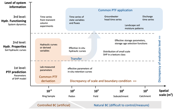
Pedotransfer functions (PTFs) are used to predict parameters of models describing the hydraulic properties of soils. The appropriateness of these predictions critically relies on the nature of the datasets for training the PTFs and the physical comprehensiveness of the models. This roadmap paper is addressed to PTF developers and users and critically reflects the utility and future of PTFs. To this end, we present a manifesto aiming at a paradigm shift in PTF research.
Lukas Strebel, Heye Bogena, Harry Vereecken, Mie Andreasen, Sergio Aranda-Barranco, and Harrie-Jan Hendricks Franssen
Hydrol. Earth Syst. Sci., 28, 1001–1026, https://doi.org/10.5194/hess-28-1001-2024, https://doi.org/10.5194/hess-28-1001-2024, 2024
Short summary
Short summary
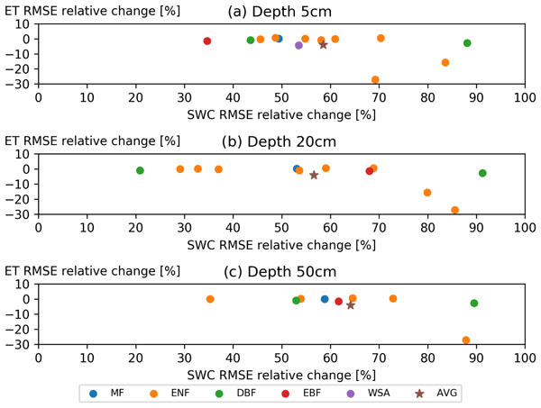
We present results from using soil water content measurements from 13 European forest sites in a state-of-the-art land surface model. We use data assimilation to perform a combination of observed and modeled soil water content and show the improvements in the representation of soil water content. However, we also look at the impact on evapotranspiration and see no corresponding improvements.
Denise Degen, Daniel Caviedes Voullième, Susanne Buiter, Harrie-Jan Hendricks Franssen, Harry Vereecken, Ana González-Nicolás, and Florian Wellmann
Geosci. Model Dev., 16, 7375–7409, https://doi.org/10.5194/gmd-16-7375-2023, https://doi.org/10.5194/gmd-16-7375-2023, 2023
Short summary
Short summary
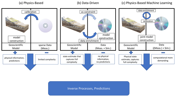
In geosciences, we often use simulations based on physical laws. These simulations can be computationally expensive, which is a problem if simulations must be performed many times (e.g., to add error bounds). We show how a novel machine learning method helps to reduce simulation time. In comparison to other approaches, which typically only look at the output of a simulation, the method considers physical laws in the simulation itself. The method provides reliable results faster than standard.
Theresa Boas, Heye Reemt Bogena, Dongryeol Ryu, Harry Vereecken, Andrew Western, and Harrie-Jan Hendricks Franssen
Hydrol. Earth Syst. Sci., 27, 3143–3167, https://doi.org/10.5194/hess-27-3143-2023, https://doi.org/10.5194/hess-27-3143-2023, 2023
Short summary
Short summary
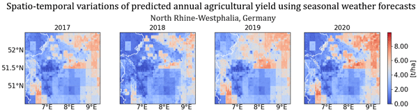
In our study, we tested the utility and skill of a state-of-the-art forecasting product for the prediction of regional crop productivity using a land surface model. Our results illustrate the potential value and skill of combining seasonal forecasts with modelling applications to generate variables of interest for stakeholders, such as annual crop yield for specific cash crops and regions. In addition, this study provides useful insights for future technical model evaluations and improvements.
François Jonard, Andrew F. Feldman, Daniel J. Short Gianotti, and Dara Entekhabi
Biogeosciences, 19, 5575–5590, https://doi.org/10.5194/bg-19-5575-2022, https://doi.org/10.5194/bg-19-5575-2022, 2022
Short summary
Short summary
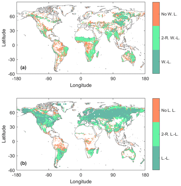
We investigate the spatial and temporal patterns of light and water limitation in plant function at the ecosystem scale. Using satellite observations, we characterize the nonlinear relationships between sun-induced chlorophyll fluorescence (SIF) and water and light availability. This study highlights that soil moisture limitations on SIF are found primarily in drier environments, while light limitations are found in intermediately wet regions.
Jordan Bates, Francois Jonard, Rajina Bajracharya, Harry Vereecken, and Carsten Montzka
AGILE GIScience Ser., 3, 23, https://doi.org/10.5194/agile-giss-3-23-2022, https://doi.org/10.5194/agile-giss-3-23-2022, 2022
Wei Qu, Heye Bogena, Christoph Schüth, Harry Vereecken, Zongmei Li, and Stephan Schulz
Geosci. Model Dev. Discuss., https://doi.org/10.5194/gmd-2022-131, https://doi.org/10.5194/gmd-2022-131, 2022
Publication in GMD not foreseen
Short summary
Short summary
We applied the global sensitivity analysis LH-OAT to the integrated hydrology model ParFlow-CLM to investigate the sensitivity of the 12 parameters for different scenarios. And we found that the general patterns of the parameter sensitivities were consistent, however, for some parameters a significantly larger span of the sensitivities was observed, especially for the higher slope and in subarctic climatic scenarios.
Nicholas Jarvis, Jannis Groh, Elisabet Lewan, Katharina H. E. Meurer, Walter Durka, Cornelia Baessler, Thomas Pütz, Elvin Rufullayev, and Harry Vereecken
Hydrol. Earth Syst. Sci., 26, 2277–2299, https://doi.org/10.5194/hess-26-2277-2022, https://doi.org/10.5194/hess-26-2277-2022, 2022
Short summary
Short summary
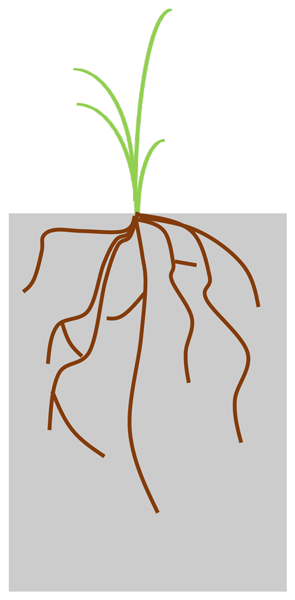
We apply an eco-hydrological model to data on soil water balance and grassland growth obtained at two sites with contrasting climates. Our results show that the grassland in the drier climate had adapted by developing deeper roots, which maintained water supply to the plants in the face of severe drought. Our study emphasizes the importance of considering such plastic responses of plant traits to environmental stress in the modelling of soil water balance and plant growth under climate change.
Heye Reemt Bogena, Martin Schrön, Jannis Jakobi, Patrizia Ney, Steffen Zacharias, Mie Andreasen, Roland Baatz, David Boorman, Mustafa Berk Duygu, Miguel Angel Eguibar-Galán, Benjamin Fersch, Till Franke, Josie Geris, María González Sanchis, Yann Kerr, Tobias Korf, Zalalem Mengistu, Arnaud Mialon, Paolo Nasta, Jerzy Nitychoruk, Vassilios Pisinaras, Daniel Rasche, Rafael Rosolem, Hami Said, Paul Schattan, Marek Zreda, Stefan Achleitner, Eduardo Albentosa-Hernández, Zuhal Akyürek, Theresa Blume, Antonio del Campo, Davide Canone, Katya Dimitrova-Petrova, John G. Evans, Stefano Ferraris, Félix Frances, Davide Gisolo, Andreas Güntner, Frank Herrmann, Joost Iwema, Karsten H. Jensen, Harald Kunstmann, Antonio Lidón, Majken Caroline Looms, Sascha Oswald, Andreas Panagopoulos, Amol Patil, Daniel Power, Corinna Rebmann, Nunzio Romano, Lena Scheiffele, Sonia Seneviratne, Georg Weltin, and Harry Vereecken
Earth Syst. Sci. Data, 14, 1125–1151, https://doi.org/10.5194/essd-14-1125-2022, https://doi.org/10.5194/essd-14-1125-2022, 2022
Short summary
Short summary
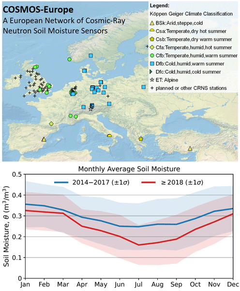
Monitoring of increasingly frequent droughts is a prerequisite for climate adaptation strategies. This data paper presents long-term soil moisture measurements recorded by 66 cosmic-ray neutron sensors (CRNS) operated by 24 institutions and distributed across major climate zones in Europe. Data processing followed harmonized protocols and state-of-the-art methods to generate consistent and comparable soil moisture products and to facilitate continental-scale analysis of hydrological extremes.
Lukas Strebel, Heye R. Bogena, Harry Vereecken, and Harrie-Jan Hendricks Franssen
Geosci. Model Dev., 15, 395–411, https://doi.org/10.5194/gmd-15-395-2022, https://doi.org/10.5194/gmd-15-395-2022, 2022
Short summary
Short summary
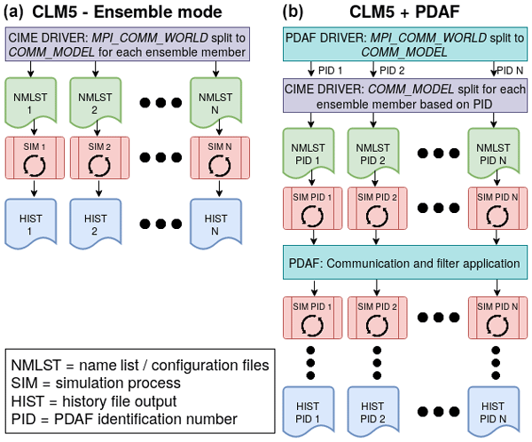
We present the technical coupling between a land surface model (CLM5) and the Parallel Data Assimilation Framework (PDAF). This coupling enables measurement data to update simulated model states and parameters in a statistically optimal way. We demonstrate the viability of the model framework using an application in a forested catchment where the inclusion of soil water measurements significantly improved the simulation quality.
Veronika Forstner, Jannis Groh, Matevz Vremec, Markus Herndl, Harry Vereecken, Horst H. Gerke, Steffen Birk, and Thomas Pütz
Hydrol. Earth Syst. Sci., 25, 6087–6106, https://doi.org/10.5194/hess-25-6087-2021, https://doi.org/10.5194/hess-25-6087-2021, 2021
Short summary
Short summary
Lysimeter-based manipulative and observational experiments were used to identify responses of water fluxes and aboveground biomass (AGB) to climatic change in permanent grassland. Under energy-limited conditions, elevated temperature actual evapotranspiration (ETa) increased, while seepage, dew, and AGB decreased. Elevated CO2 mitigated the effect on ETa. Under water limitation, elevated temperature resulted in reduced ETa, and AGB was negatively correlated with an increasing aridity.
Yafei Huang, Jonas Weis, Harry Vereecken, and Harrie-Jan Hendricks Franssen
Hydrol. Earth Syst. Sci. Discuss., https://doi.org/10.5194/hess-2021-569, https://doi.org/10.5194/hess-2021-569, 2021
Manuscript not accepted for further review
Short summary
Short summary
Trends in agricultural droughts cannot be easily deduced from measurements. Here trends in agricultural droughts over 31 German and Dutch sites were calculated with model simulations and long-term observed meteorological data as input. We found that agricultural droughts are increasing although precipitation hardly decreases. The increase is driven by increase in evapotranspiration. The year 2018 was for half of the sites the year with the most extreme agricultural drought in the last 55 years.
Cited articles
Aboutalebi, M., Torres-Rua, A. F., McKee, M., Nieto, H., Kustas, W., and Coopmans, C.: The impact of shadows on partitioning of radiometric temperature to canopy and soil temperature based on the contextual two-source energy balance model (TSEB-2T), P. Soc. Photo.-Opt. Ins., 11008, https://doi.org/10.1117/12.2519685, 2019.
Acharya, B. and Sharma, V.: Comparison of Satellite Driven Surface Energy Balance Models in Estimating Crop Evapotranspiration in Semi-Arid to Arid Inter-Mountain Region, Remote Sensing, 13, https://doi.org/10.3390/rs13091822, 2021.
Ali, M., Montzka, C., Stadler, A., Menz, G., Thonfeld, F., and Vereecken, H.: Estimation and Validation of RapidEye-Based Time-Series of Leaf Area Index for Winter Wheat in the Rur Catchment (Germany), Remote Sensing, 7, 2808–2831, https://doi.org/10.3390/rs70302808, 2015.
Allen, R. G., Pereira, L. S., Raes, D., and Smith, M.: Crop evapotranspiration – Guidelines for computing crop water requirements, FAO Irrigation and Drainage Paper 56, Food and Agriculture Organization of the United Nations, Rome, https://www.fao.org/4/X0490E/X0490E00.htm (last access: 15 March 2026), 1998.
Amani, S. and Shafizadeh-Moghadam, H.: A review of machine learning models and influential factors for estimating evapotranspiration using remote sensing and ground-based data, Agr. Water Manage., 284, 108324, https://doi.org/10.1016/j.agwat.2023.108324, 2023.
Amin, E., Verrelst, J., Rivera-Caicedo, J. P., Pipia, L., Ruiz-Verdú, A., and Moreno, J.: Prototyping Sentinel-2 green LAI and brown LAI products for cropland monitoring, Remote Sens. Environ., 255, 112168, https://doi.org/10.1016/j.rse.2020.112168, 2021.
Anderson, M. C., Kustas, W. P., Norman, J. M., Diak, G. T., Hain, C. R., Gao, F., Yang, Y., Knipper, K. R., Xue, J., Yang, Y., Crow, W. T., Holmes, T. R. H., Nieto, H., Guzinski, R., Otkin, J. A., Mecikalski, J. R., Cammalleri, C., Torres-Rua, A. T., Zhan, X., Fang, L., Colaizzi, P. D., and Agam, N.: A brief history of the thermal IR-based Two-Source Energy Balance (TSEB) model – diagnosing evapotranspiration from plant to global scales, Agr. Forest Meteorol., 350, 109951, https://doi.org/10.1016/j.agrformet.2024.109951, 2024.
Ankela, C. B., Neelima, T. L., Chandrasekar, K., Misra, C., Avil Kumar, K., and Noorzai, A.: Spatiotemporal assessment of maize evapotranspiration and surface energy fluxes under varying irrigation regimes using UAV based METRIC, Sci. Rep., 16, 4302, https://doi.org/10.1038/s41598-025-33916-5, 2026.
Bates, J., Montzka, C., Vereecken, H., and Jonard, F.: UAV Multi-Sensor Derived Inputs for TSEB-PT Evapotranspiration Estimation in Sugar Beet, Potato, and Winter Wheat, Zenodo [data set], https://doi.org/10.5281/zenodo.23056700, 2026a.
Bates, J. S., Montzka, C., Schmidt, M., and Jonard, F.: Estimating Canopy Density Parameters Time-Series for Winter Wheat Using UAS Mounted LiDAR, Remote Sensing, 13, 352, https://doi.org/10.3390/rs13030352, 2021.
Bates, J. S., Montzka, C., Bajracharya, R., Vereecken, H., and Jonard, F.: Wheat biomass estimation across crop development using UAV LiDAR structure–intensity fusion alongside multispectral and thermal data, Biogeosciences, 23, 6179–6210, https://doi.org/10.5194/bg-23-6179-2026, 2026b.
Bellvert, J., Jofre-Ĉekalović, C., Pelechá, A., Mata, M., and Nieto, H.: Feasibility of Using the Two-Source Energy Balance Model (TSEB) with Sentinel-2 and Sentinel-3 Images to Analyze the Spatio-Temporal Variability of Vine Water Status in a Vineyard, Remote Sensing, 12, 2299, https://doi.org/10.3390/rs12142299, 2020.
Bozorgi, M., Cristóbal, J., and Pàmies-Sans, M.: Evaluating the Two-Source Energy Balance Model Using MODIS Data for Estimating Evapotranspiration Time Series on a Regional Scale, Remote Sensing, 16, 4587, https://doi.org/10.3390/rs16234587, 2024.
Brenner, C., Thiem, C. E., Wizemann, H.-D., Bernhardt, M., and Schulz, K.: Estimating spatially distributed turbulent heat fluxes from high-resolution thermal imagery acquired with a UAV system, Int. J. Remote Sens., 38, 3003–3026, https://doi.org/10.1080/01431161.2017.1280202, 2017.
Brenner, C., Zeeman, M., Bernhardt, M., and Schulz, K.: Estimation of evapotranspiration of temperate grassland based on high-resolution thermal and visible range imagery from unmanned aerial systems, Int. J. Remote Sens., 39, 5141–5174, 2018.
Brogi, C., Huisman, J. A., Herbst, M., Weihermüller, L., Klosterhalfen, A., Montzka, C., Reichenau, T. G., and Vereecken, H.: Simulation of spatial variability in crop leaf area index and yield using agroecosystem modeling and geophysics-based quantitative soil information, Vadose Zone J., 19, e20009, https://doi.org/10.1002/vzj2.20009, 2020.
Budzier, H. and Gerlach, G.: Calibration of uncooled thermal infrared cameras, J. Sens. Sens. Syst., 4, 187–197, https://doi.org/10.5194/jsss-4-187-2015, 2015.
Bukowiecki, J., Rose, T., Ehlers, R., and Kage, H.: High-Throughput Prediction of Whole Season Green Area Index in Winter Wheat With an Airborne Multispectral Sensor, Front. Plant Sci., 10, 1798, https://doi.org/10.3389/fpls.2019.01798, 2020.
Burchard-Levine, V., Nieto, H., Riaño, D., Migliavacca, M., El-Madany, T. S., Guzinski, R., Carrara, A., and Martín, M. P.: The effect of pixel heterogeneity for remote sensing-based retrievals of evapotranspiration in a semi-arid tree–grass ecosystem, Remote Sens. Environ., 260, 112440, https://doi.org/10.1016/j.rse.2021.112440, 2021.
Cammalleri, C., Anderson, M. C., and Kustas, W. P.: Upscaling of evapotranspiration fluxes from instantaneous to daytime scales for thermal remote sensing applications, Hydrol. Earth Syst. Sci., 18, 1885–1894, https://doi.org/10.5194/hess-18-1885-2014, 2014.
Campbell, G. S.: Derivation of an angle density function for canopies with ellipsoidal leaf angle distributions, Agr. Forest Meteorol., 49, 173–176, 1990.
Campbell, G. S. and Norman, J. M.: An Introduction to Environmental Biophysics, 2nd edn., Springer, New York, https://doi.org/10.1007/978-1-4612-1626-1, 1998.
Cao, L., Liu, H., Fu, X., Zhang, Z., Shen, X., and Ruan, H.: Comparison of UAV LiDAR and Digital Aerial Photogrammetry Point Clouds for Estimating Forest Structural Attributes in Subtropical Planted Forests, Forests, 10, 145, https://doi.org/10.3390/f10020145, 2019.
Chandel, A. K., Molaei, B., Khot, L. R., Peters, R. T., and Stöckle, C. O.: High Resolution Geospatial Evapotranspiration Mapping of Irrigated Field Crops Using Multispectral and Thermal Infrared Imagery with METRIC Energy Balance Model, Drones, 4, 52, https://doi.org/10.3390/drones4030052, 2020.
Chirouze, J., Boulet, G., Jarlan, L., Fieuzal, R., Rodriguez, J. C., Ezzahar, J., Er-Raki, S., Bigeard, G., Merlin, O., Garatuza-Payan, J., Watts, C., and Chehbouni, G.: Intercomparison of four remote-sensing-based energy balance methods to retrieve surface evapotranspiration and water stress of irrigated fields in semi-arid climate, Hydrol. Earth Syst. Sci., 18, 1165–1188, https://doi.org/10.5194/hess-18-1165-2014, 2014.
Choudhury, B. J., Idso, S. B., and Reginato, R. J.: Analysis of an empirical model for soil heat flux under a growing wheat crop for estimating evaporation by an infrared-temperature based energy balance equation, Agr. Forest Meteorol., 39, 283–297, 1987.
Colaizzi, P.: Advances in a Two-Source Energy Balance Model: Partitioning of Evaporation and Transpiration for Cotton, T. ASABE, 59, 181–197, 2016.
Colaizzi, P. D., Agam, N., Tolk, J. A., Evett, S. R., and Howell, T. A.: Two-Source Energy Balance Model to Calculate E, T, and ET: Comparison of Priestley-Taylor and Penman-Monteith Formulations and Two Time Scaling Methods, T. ASABE, 479–498, https://doi.org/10.13031/trans.57.10423, 2014.
de Lima, G. S. A., Ferreira, M. E., Sales, J. C., de Souza Passos, J., Maggiotto, S. R., Madari, B. E., de Melo Carvalho, M. T., and de Almeida Machado, P. L. O.: Evapotranspiration measurements in pasture, crops, and native Brazilian Cerrado based on UAV-borne multispectral sensor, Environ. Monit. Assess., 196, 1105, https://doi.org/10.1007/s10661-024-13224-7, 2024.
Derardja, B., Khadra, R., Abdelmoneim, A. A. A., El-Shirbeny, M. A., Valsamidis, T., De Pasquale, V., Deflorio, A. M., and Volden, E.: Advancements in Remote Sensing for Evapotranspiration Estimation: A Comprehensive Review of Temperature-Based Models, Remote Sensing, 16, 11, https://doi.org/10.3390/rs16111927, 2024.
Dreier, A., Lopez, G., Bajracharya, R., Kuhlmann, H., and Klingbeil, L.: Structural wheat trait estimation using UAV-based laser scanning data: Analysis of critical aspects and recommendations based on a case study, Precis. Agric., 26, 18, https://doi.org/10.1007/s11119-024-10202-4, 2025.
Duran-Gomez, M. R., Torres-Rua, A., Hipps, L., Kustas, W., Bambach, N. E., Knipper, K., Wright, I., McElrone, A. J., Prueger, J. H., Alfieri, J. G., Coopmans, C., Meza, K., Gowing, I., Nocco, M., Castro, S. J., Gal, A., and Tolentino, P.: Influence of almond's canopy-induced shadows on actual evapotranspiration estimation by the TSEB model using sUAS multispectral and thermal imagery, Irrigation Sci., 44, 54, https://doi.org/10.1007/s00271-026-01092-7, 2026.
Ebert, L. A., Talib, A., Zipper, S. C., Desai, A. R., U, K. T. P., Chisholm, A. J., Prater, J., and Nocco, M. A.: How High to Fly? Mapping Evapotranspiration from Remotely Piloted Aircrafts at Different Elevations, Remote Sensing, 14, https://doi.org/10.3390/rs14071660, 2022.
El Hazdour, I., Le Page, M., Hanich, L., Chakir, A., Lopez, O., and Jarlan, L.: A GEE TSEB workflow for daily high-resolution fully remote sensing evapotranspiration: Validation over four crops in semi-arid conditions and comparison with the SSEBop experimental product, Environ. Modell. Softw., 187, 106365, https://doi.org/10.1016/j.envsoft.2025.106365, 2025.
Elfarkh, J., Ezzahar, J., Er-Raki, S., Simonneaux, V., Ait Hssaine, B., Rachidi, S., Brut, A., Rivalland, V., Khabba, S., Chehbouni, A., and Jarlan, L.: Multi-Scale Evaluation of the TSEB Model over a Complex Agricultural Landscape in Morocco, Remote Sensing, 12, 1181, https://doi.org/10.3390/rs12071181, 2020.
Elfarkh, J., Johansen, K., El Hajj, M. M., Almashharawi, S. K., and McCabe, M. F.: Evapotranspiration, gross primary productivity and water use efficiency over a high-density olive orchard using ground and satellite based data, Agr. Water Manage., 287, 108423, https://doi.org/10.1016/j.agwat.2023.108423, 2023.
Ellsäßer, F., Röll, A., Stiegler, C., Hendrayanto, and Hölscher, D.: Introducing QWaterModel, a QGIS plugin for predicting evapotranspiration from land surface temperatures, Environ. Modell. Softw., 130, 104739, https://doi.org/10.1016/j.envsoft.2020.104739, 2020.
Flint, E. A., Hopkins, B. G., Svedin, J. D., Kerry, R., Heaton, M. J., Jensen, R. R., Campbell, C. S., Yost, M. A., and Hansen, N. C.: Irrigation Zone Delineation and Management with a Field-Scale Variable Rate Irrigation System in Winter Wheat, Agronomy, 13, https://doi.org/10.3390/agronomy13041125, 2023.
Gao, R., Torres-Rua, A., Nassar, A., Alfieri, J., Aboutalebi, M., Hipps, L., Ortiz, N. B., McElrone, A. J., Coopmans, C., Kustas, W., White, W., McKee, L., Alsina, M. del M., Dokoozlian, N., Sanchez, L., Prueger, J. H., Nieto, H., and Agam, N.: Evapotranspiration partitioning assessment using a machine-learning-based leaf area index and the two-source energy balance model with sUAV information, Autonomous Air and Ground Sensing Systems for Agricultural Optimization and Phenotyping VI, 11747, 117470N, https://doi.org/10.1117/12.2586259, 2021.
Gao, R., Torres-Rua, A. F., Nieto, H., Zahn, E., Hipps, L., Kustas, W. P., Alsina, M. M., Bambach, N., Castro, S. J., Prueger, J. H., Alfieri, J., McKee, L. G., White, W. A., Gao, F., McElrone, A. J., Anderson, M., Knipper, K., Coopmans, C., Gowing, I., Agam, N., Sanchez, L., and Dokoozlian, N.: ET Partitioning Assessment Using the TSEB Model and sUAS Information across California Central Valley Vineyards, Remote Sens., 15, 756, https://doi.org/10.3390/rs15030756, 2023.
García-Santos, V., Sánchez, J. M., and Cuxart, J.: Evapotranspiration Acquired with Remote Sensing Thermal-Based Algorithms: A State-of-the-Art Review, Remote Sensing, 14, 3440, https://doi.org/10.3390/rs14143440, 2022.
Ghiat, I., Mackey, H. R., and Al-Ansari, T.: A Review of Evapotranspiration Measurement Models, Techniques and Methods for Open and Closed Agricultural Field Applications, Water, 13, 2523, https://doi.org/10.3390/w13182523, 2021.
Giardina, F., Gentine, P., Konings, A. G., Seneviratne, S. I., and Stocker, B. D.: Diagnosing evapotranspiration responses to water deficit across biomes using deep learning, New Phytol., 240, 968–983, https://doi.org/10.1111/nph.19197, 2023.
Gogler, S., Madura, H., Krupiński, M., Bieszczad, G., and Sosnowski, T.: Non-Uniformity Correction in Microbolometer Array with Temperature Influence Compensation, Metrol. Meas. Syst., 2014, 709–718, 2014.
Guzinski, R., Nieto, H., Sandholt, I., and Karamitilios, G.: Modelling High-Resolution Actual Evapotranspiration through Sentinel-2 and Sentinel-3 Data Fusion, Remote Sensing, 12, 9, https://doi.org/10.3390/rs12091433, 2020.
Gómez-Candón, D., Bellvert, J., and Royo, C.: Performance of the Two-Source Energy Balance (TSEB) Model as a Tool for Monitoring the Response of Durum Wheat to Drought by High-Throughput Field Phenotyping, Front. Plant Sci., 12, https://doi.org/10.3389/fpls.2021.658357, 2021.
Han, X., Thomasson, J. A., Swaminathan, V., Wang, T., Siegfried, J., Raman, R., Rajan, N., and Neely, H.: Field-Based Calibration of Unmanned Aerial Vehicle Thermal Infrared Imagery with Temperature-Controlled References, Sensors, 20, 7098, https://doi.org/10.3390/s20247098, 2020.
Heinemann, S., Siegmann, B., Thonfeld, F., Muro, J., Jedmowski, C., Kemna, A., Kraska, T., Muller, O., Schultz, J., Udelhoven, T., Wilke, N., and Rascher, U.: Land Surface Temperature Retrieval for Agricultural Areas Using a Novel UAV Platform Equipped with a Thermal Infrared and Multispectral Sensor, Remote Sensing, 12, https://doi.org/10.3390/rs12071075, 2020.
Hirschi, M., Michel, D., Lehner, I., and Seneviratne, S. I.: A site-level comparison of lysimeter and eddy covariance flux measurements of evapotranspiration, Hydrol. Earth Syst. Sci., 21, 1809–1825, https://doi.org/10.5194/hess-21-1809-2017, 2017.
Hoffmann, H., Nieto, H., Jensen, R., Guzinski, R., Zarco-Tejada, P., and Friborg, T.: Estimating evaporation with thermal UAV data and two-source energy balance models, Hydrol. Earth Syst. Sci., 20, 697–713, https://doi.org/10.5194/hess-20-697-2016, 2016.
Hunt Jr., E. R. and Daughtry, C. S. T.: What good are unmanned aircraft systems for agricultural remote sensing and precision agriculture?, Int. J. Remote Sens., 39, 5345–5376, 2018.
Hütt, C., Bolten, A., Hüging, H., and Bareth, G.: UAV LiDAR Metrics for Monitoring Crop Height, Biomass and Nitrogen Uptake: A Case Study on a Winter Wheat Field Trial, PFG – Journal of Photogrammetry, Remote Sensing and Geoinformation Science, 91, 65–76, https://doi.org/10.1007/s41064-022-00228-6, 2022.
Jaafar, H. H. and Sujud, H. L.: High resolution evapotranspiration from UAV multispectral thermal imagery: Validation and comparison with EC, Landsat, and fused S2-MODIS HSEB ET, Int. J. Appl. Earth Obs., 136, 104359, https://doi.org/10.1016/j.jag.2025.104359, 2025.
Jaafar, H. H., Mourad, R. M., Kustas, W. P., and Anderson, M. C.: A Global Implementation of Single- and Dual-Source Surface Energy Balance Models for Estimating Actual Evapotranspiration at 30-m Resolution Using Google Earth Engine, Water Resour. Res., 58, e2022WR032800, https://doi.org/10.1029/2022WR032800, 2022.
Jia, K., Li, Y., Liang, S., Wei, X., and Yao, Y.: Combining Estimation of Green Vegetation Fraction in an Arid Region from Landsat 7 ETM+ Data, Remote Sensing, 9, 1121, https://doi.org/10.3390/rs9111121, 2017.
Jonard F., De Cannière S., Brüggemann N., Gentine P., Short Gianotti D. J., Lobet G., Miralles D. J., Montzka C., Pagán B. R., Rascher U., and Vereecken, H.: Value of chlorophyll fluorescence for quantifying hydrological states and fluxes: Current status and challenges, Agr. Forest Meteorol., 291, 108088, https://doi.org/10.1016/j.agrformet.2020.108088, 2020.
Kavya, B. M. and Mahadevaiah, T.: Enhancing Estimation Of Evapotranspiration In Sugarcane Cultivation Using Lysimeter Data And Deep Learning Techniques, International Journal of Intelligent Systems and Applications in Engineering, 12, https://www.ijisae.org/index.php/IJISAE/article/view/7232 (last access: 13 October 2026), 2024.
Kelly, J., Kljun, N., Olsson, P.-O., Mihai, L., Liljeblad, B., Weslien, P., Klemedtsson, L., and Eklundh, L.: Challenges and Best Practices for Deriving Temperature Data from an Uncalibrated UAV Thermal Infrared Camera, Remote Sensing, 11, 567, https://doi.org/10.3390/rs11050567, 2019.
Kljun, N., Calanca, P., Rotach, M. W., and Schmid, H. P.: A simple two-dimensional parameterisation for Flux Footprint Prediction (FFP), Geosci. Model Dev., 8, 3695–3713, https://doi.org/10.5194/gmd-8-3695-2015, 2015.
Kool, D., Kustas, W. P., Ben-Gal, A., and Agam, N.: Energy partitioning between plant canopy and soil, performance of the two-source energy balance model in a vineyard, Agr. Forest Meteorol., 300, 108328, https://doi.org/10.1016/j.agrformet.2021.108328, 2021.
Kustas, W. and Anderson, M.: Advances in thermal infrared remote sensing for land surface modeling, Agr. Forest Meteorol., 149, 2071–2081, 2009.
Kustas, W. P. and Daughtry, C. S. T.: Estimation of the soil heat flux/net radiation ratio from spectral data, Agr. Forest Meteorol., 49, 205–223, 1990.
Kustas, W. P. and Norman, J. M.: Evaluation of soil and vegetation heat flux predictions using a simple two-source model with radiometric temperatures for partial canopy cover, Agr. Forest Meteorol., 94, 13–29, 1999.
Kustas, W. P., Nieto, H., Morillas, L., Anderson, M. C., Alfieri, J. G., Hipps, L. E., Villagarcía, L., Domingo, F., and Garcia, M.: Revisiting the paper “Using radiometric surface temperature for surface energy flux estimation in Mediterranean drylands from a two-source perspective.”, Remote Sens. Environ., 184, 645–653, 2016.
Li, Y., Kustas, W. P., Huang, C., Nieto, H., Haghighi, E., Anderson, M. C., Domingo, F., Garcia, M., and Scott, R. L.: Evaluating Soil Resistance Formulations in Thermal-Based Two-Source Energy Balance (TSEB) Model: Implications for Heterogeneous Semiarid and Arid Regions, Water Resour. Res., 55, 1059–1078, 2019.
Liu, Y., Zhang, S., Zhang, J., Tang, L., and Bai, Y.: Assessment and Comparison of Six Machine Learning Models in Estimating Evapotranspiration over Croplands Using Remote Sensing and Meteorological Factors, Remote Sensing, 13, 19, https://doi.org/10.3390/rs13193838, 2021.
Liu, H., Song, W., Lv, J., Gui, R., Shi, Y., Lu, Y., Li, M., Chen, L., and Chen, X.: Precise Drought Threshold Monitoring in Winter Wheat Using the Unmanned Aerial Vehicle Thermal Method, Remote Sensing, 16, 4, https://doi.org/10.3390/rs16040710, 2024.
Liyew, C. M., Ferraris, S., Di Nardo, E., and Meo, R.: A review of feature selection methods for actual evapotranspiration prediction, Artif. Intell. Rev., 58, 292, https://doi.org/10.1007/s10462-025-11298-4, 2025.
Lu, S., Xuan, J., Zhang, T., Bai, X., Tian, F., and Ortega-Farias, S.: Effect of the Shadow Pixels on Evapotranspiration Inversion of Vineyard: A High-Resolution UAV-Based and Ground-Based Remote Sensing Measurements, Remote Sensing, 14, https://doi.org/10.3390/rs14092259, 2022.
Lun, S., Liu, T., Bao, Y., Hao, L., Duan, L., Zhang, W., Zhang, S., Zhang, Y., Singh, V. P., and Wang, D.: Resistance optimization and applicability of the TSEB model in desert–oasis areas, Agr. Water Manage., 326, 110231, https://doi.org/10.1016/j.agwat.2026.110231, 2026.
Ma, H., Song, J., and Wang, J.: Forest canopy LAI and vertical FAVD profile inversion from airborne full-waveform LiDAR data based on a radiative transfer model, Remote Sensing, 7, 1897–1914, https://doi.org/10.3390/rs70201897, 2015.
Mendiguren, G., Koch, J., and Stisen, S.: Spatial pattern evaluation of a calibrated national hydrological model – a remote-sensing-based diagnostic approach, Hydrol. Earth Syst. Sci., 21, 5987–6005, https://doi.org/10.5194/hess-21-5987-2017, 2017.
Mohan, M. M. P., Kanchirapuzha, R., and Varma, M. R. R.: Review of approaches for the estimation of sensible heat flux in remote sensing-based evapotranspiration models, J. Appl. Remote Sens., 14, 041501, https://doi.org/10.1117/1.JRS.14.041501, 2020.
Mokhtari, A., Ahmadi, A., Daccache, A., and Drechsler, K.: Actual Evapotranspiration from UAV Images: A Multi-Sensor Data Fusion Approach, Remote Sensing, 13, 2315, https://doi.org/10.3390/rs13122315, 2021.
Montzka, C., Donat, M., Raj, R., Welter, P., and Bates, J. S.: Sensitivity of LiDAR Parameters to Aboveground Biomass in Winter Spelt, Drones, 7, 121, https://doi.org/10.3390/drones7020121, 2023.
Nassar, A., Torres-Rua, A., Kustas, W., Nieto, H., McKee, M., Hipps, L., Stevens, D., Alfieri, J., Alsina, M., McKee, L., Coopmans, C., Sanchez, L., and Dokoozlian, N.: Influence of Model Grid Size on the Estimation of Surface Fluxes Using the Two Source Energy Balance Model and sUAS Imagery in Vineyards, Remote Sensing, 12, 342, https://doi.org/10.3390/rs12030342, 2020.
Nassar, A., Torres-Rua, A., Kustas, W., Alfieri, J., Hipps, L., Prueger, J., Nieto, H., Alsina, M. M., White, W., McKee, L., Coopmans, C., Sanchez, L., and Dokoozlian, N.: Assessing Daily Evapotranspiration Methodologies from One-Time-of-Day sUAS and EC Information in the GRAPEX Project, Remote Sensing, 13, 2887, https://doi.org/10.3390/rs13152887, 2021.
Nassar, A., Torres-Rua, A., Hipps, L., Kustas, W., McKee, M., Stevens, D., Nieto, H., Keller, D., Gowing, I., and Coopmans, C.: Using Remote Sensing to Estimate Scales of Spatial Heterogeneity to Analyze Evapotranspiration Modeling in a Natural Ecosystem, Remote Sensing, 14, 372, https://doi.org/10.3390/rs14020372, 2022.
Nieto, H., Guzinski, R., and Kustas, W. P.: pyTSEB: A Python Two Source Energy Balance model for estimation of evapotranspiration with remote sensing data, version 2.2, Zenodo [code], https://doi.org/10.5281/zenodo.594732, 2018.
Nieto, H., Kustas, W. P., Torres-Rúa, A., Alfieri, J. G., Gao, F., Anderson, M. C., White, W. A., Song, L., Alsina, M. M., Prueger, J. H., McKee, M., Elarab, M., and McKee, L. G.: Evaluation of TSEB turbulent fluxes using different methods for the retrieval of soil and canopy component temperatures from UAV thermal and multispectral imagery, Irrigation Sci., 37, 389–406, 2019.
Nieto, H., Alsina, M. M., Kustas, W. P., García-Tejera, O., Chen, F., Bambach, N., Gao, F., Alfieri, J. G., Hipps, L. E., Prueger, J. H., McKee, L. G., Zahn, E., Bou-Zeid, E., McElrone, A. J., Castro, S. J., and Dokoozlian, N.: Evaluating different metrics from the thermal-based two-source energy balance model for monitoring grapevine water stress, Irrigation Sci., 40, 697–713, https://doi.org/10.1007/s00271-022-00790-2, 2022.
Niu, H., Zhao, T., Wang, D., and Chen, Y.: Evapotranspiration Estimation with UAVs in Agriculture: A Review, Preprints.org, https://doi.org/10.20944/preprints201907.0124.v1, 2019.
Niu, H., Hollenbeck, D., Zhao, T., Wang, D., and Chen, Y.: Evapotranspiration Estimation with Small UAVs in Precision Agriculture, Sensors, 20, 6427, https://doi.org/10.3390/s20226427, 2020.
Norman, J. M., Kustas, W. P., and Humes, K. S.: Source approach for estimating soil and vegetation energy fluxes in observations of directional radiometric surface temperature, Agr. Forest Meteorol., 77, 263–293, 1995.
Oguntunde, P., Olukunle, O. J., Fasinmirin, J., and Abiolu, O. A.: Performance of the SunScan canopy analysis system in estimating leaf area index of maize, Agricultural Engineering International: The CIGR Journal, 14, 1–7, https://cigrjournal.org/index.php/Ejounral/article/view/1823 (last access: 13 October 2026),, 2012.
Ortiz, M. S., Ducati, J. R., Espinoza, J., and Monteiro, R. C.: Evapotranspiration Estimate Using Energy Balance Two Source Model With UAV Images: A Study in Vineyard, Am. J. Eng. Res., 8, 60–69, https://www.ajer.org/papers/Vol-8-issue-8/H08086069.pdf (last access: 13 October 2026), 2019.
Park, S., Ryu, D., Fuentes, S., Chung, H., O'Connell, M., and Kim, J.: Mapping Very-High-Resolution Evapotranspiration from Unmanned Aerial Vehicle (UAV) Imagery, ISPRS Int. J. Geo-Inf., 10, https://doi.org/10.3390/ijgi10040211, 2021.
Pereira, A. and Pires, L.: Evapotranspiration and Water Management for Crop Production, https://doi.org/10.5772/20081, 2011.
Sagan, V., Maimaitijiang, M., Sidike, P., Eblimit, K., Peterson, K. T., Hartling, S., Esposito, F., Khanal, K., Newcomb, M., Pauli, D., Ward, R., Fritschi, F., Shakoor, N., and Mockler, T.: UAV-Based High Resolution Thermal Imaging for Vegetation Monitoring, and Plant Phenotyping Using ICI 8640 P, FLIR Vue Pro R 640, and thermoMap Cameras, Remote Sensing, 11, 330, https://doi.org/10.3390/rs11030330, 2019.
Schmidt, M., Bagheri, S., Becker, N., Dolfus, D., Esser, O., Graf, A., Haustein, A., Kettler, M., Kummer, S., and Mattes, J.: ETC L2 Fluxnet (half-hourly) from Selhausen Juelich, 2018-12-31–2025-09-30, ICOS RI [data set], https://hdl.handle.net/11676/-6oQN2W3wkdiVa0M-dWohuCG (last access: 13 October 2026), 2025a.
Schmidt, M., Bagheri, S., Becker, N., Dolfus, D., Esser, O., Graf, A., Haustein, A., Kettler, M., Kummer, S., and Mattes, J.: ETC L2 Meteo from Selhausen Juelich, 2018-12-31–2025-09-30, ICOS RI [data set], https://hdl.handle.net/11676/rmxzviWfbl64eSzQyqaQM8nB (last access: 13 October 2026), 2025b.
Serrano, J., Shahidian, S., Silva, J. M. da, Paixão, L., Moral, F., Carmona-Cabezas, R., Garcia, S., Palha, J., and Noéme, J.: Mapping Management Zones Based on Soil Apparent Electrical Conductivity and Remote Sensing for Implementation of Variable Rate Irrigation – Case Study of Corn under a Center Pivot, Water, 12, https://doi.org/10.3390/w12123427, 2020.
Shi, H. and Cai, X.: Extrapolability improvement of machine learning-based evapotranspiration models via domain-adversarial neural networks, Environ. Modell. Softw., 187, 106383, https://doi.org/10.1016/j.envsoft.2025.106383, 2025.
Song, L., Xu, Y., Liddell, M., Cui, Y., Liu, S., and Xu, P.: Application of a two source energy balance model coupled with satellite based soil moisture and thermal infrared data, ISPRS J. Photogramm., 204, 15–26, https://doi.org/10.1016/j.isprsjprs.2023.08.009, 2023.
Sánchez-Virosta, Á., Sánchez, J. M., Montoya, F., Gómez-Candón, D., González-Piqueras, J., Molina-Medina, A. J., and López-Urrea, R.: Assessment of different remote sensing techniques to estimate the CWSI of almond trees using canopy temperature, Int. J. Appl. Earth Obs., 142, 104737, https://doi.org/10.1016/j.jag.2025.104737, 2025.
Tan, C.-W., Zhang, P.-P., Zhou, X.-X., Wang, Z.-X., Xu, Z.-Q., Mao, W., Li, W.-X., Huo, Z.-Y., Guo, W.-S., and Yun, F.: Quantitative monitoring of leaf area index in wheat of different plant types by integrating NDVI and Beer-Lambert law, Sci. Rep., 10, 929, https://doi.org/10.1038/s41598-020-57750-z, 2020.
Tanner, C. B.: Plant Temperatures, Agron. J., 55, 210–211, 1963.
Tao, S., Song, L., Zhao, G., and Zhao, L.: Simulation and Assessment of Daily Evapotranspiration in the Heihe River Basin over a Long Time Series Based on TSEB-SM, Remote Sensing, 16, 3, https://doi.org/10.3390/rs16030462, 2024.
Thorp, K. R., Hunsaker, D. J., and French, A. N.: Assimilating Leaf Area Index Estimates from Remote Sensing into the Simulations of a Cropping Systems Model, T. ASABE, 53, 251–262, 2010.
Tunca, E.: Evaluating the performance of the TSEB model for sorghum evapotranspiration estimation using time series UAV imagery, Irrigation Sci., 42, 977–994, https://doi.org/10.1007/s00271-023-00887-2, 2023.
Tunca, E.: Evaluating machine learning and deep learning for upscaling instantaneous latent heat flux to daily scale, Irrigation Sci., 44, 40, https://doi.org/10.1007/s00271-026-01079-4, 2026.
Tunca, E., Köksal, E. S., and Taner, S. Ç.: Calibrating UAV thermal sensors using machine learning methods for improved accuracy in agricultural applications, Infrared Phys. Techn., 133, 104804, https://doi.org/10.1016/j.infrared.2023.104804, 2023.
Twine, T. E., Kustas, W. P., Norman, J. M., Cook, D. R., Houser, P. R., Meyers, T. P., Prueger, J. H., Starks, P. J., and Wesely, M. L.: Correcting eddy-covariance flux underestimates over a grassland, Agr. Forest Meteorol., 103, 279–300, https://doi.org/10.1016/S0168-1923(00)00123-4, 2000.
Virtue, J., Turner, D., Williams, G., Zeliadt, S., McCabe, M., and Lucieer, A.: Thermal Sensor Calibration for Unmanned Aerial Systems Using an External Heated Shutter, Drones, 5, 119, https://doi.org/10.3390/drones5040119, 2021.
von Hebel, C., Reynaert, S., Pauly, K., Janssens, P., Piccard, I., Vanderborght, J., van der Kruk, J., Vereecken, H., and Garré, S.: Toward high-resolution agronomic soil information and management zones delineated by ground-based electromagnetic induction and aerial drone data, Vadose Zone J., 20, e20099, https://doi.org/10.1002/vzj2.20099, 2021.
Wan, Q., Smigaj, M., Brede, B., and Kooistra, L.: Optimizing UAV-based uncooled thermal cameras in field conditions for precision agriculture, Int. J. Appl. Earth Obs., 134, 104184, https://doi.org/10.1016/j.jag.2024.104184, 2024.
Wang, W., Zou, S., Luo, Z., Zhang, W., Chen, D., and Kong, J.: Prediction of the Reference Evapotranspiration Using a Chaotic Approach, Sci. World J., 2014, e347625, https://doi.org/10.1155/2014/347625, 2014.
Wanniarachchi, S. and Sarukkalige, R.: A Review on Evapotranspiration Estimation in Agricultural Water Management: Past, Present, and Future, Hydrology, 9, 7, https://doi.org/10.3390/hydrology9070123, 2022.
Wei, J., Dong, W., Liu, S., Song, L., Zhou, J., Xu, Z., Wang, Z., Xu, T., He, X., and Sun, J.: Mapping super high resolution evapotranspiration in oasis-desert areas using UAV multi-sensor data, Agr. Water Manage., 287, 108466, https://doi.org/10.1016/j.agwat.2023.108466, 2023.
Wei, J., Luo, Y., Liu, B., and Cui, Y.: Temporal Upscaling of Agricultural Evapotranspiration with an Improved Evaporative Fraction Method, Remote Sensing, 17, https://doi.org/10.3390/rs17061016, 2025.
Wu, K. and Lambot, S.: Digital Soil Mapping Using Drone-Borne Ground-Penetrating Radar, in: Instrumentation and Measurement Technologies for Water Cycle Management, edited by: Di Mauro, A., Scozzari, A., and Soldovieri, F., Springer International Publishing, 417–436, https://doi.org/10.1007/978-3-031-08262-7_17, 2022.
Xia, T., Kustas, W. P., Anderson, M. C., Alfieri, J. G., Gao, F., McKee, L., Prueger, J. H., Geli, H. M. E., Neale, C. M. U., Sanchez, L., Alsina, M. M., and Wang, Z.: Mapping evapotranspiration with high-resolution aircraft imagery over vineyards using one- and two-source modeling schemes, Hydrol. Earth Syst. Sci., 20, 1523–1545, https://doi.org/10.5194/hess-20-1523-2016, 2016.
Yang, Y.: Remotely Sensed Evapotranspiration, in: Observation and Measurement of Ecohydrological Processes, edited by: Li, X. and Vereecken, H., 2, Springer Berlin Heidelberg, 155–200, ISBN 978-3-662-48297-1, https://doi.org/10.1007/978-3-662-48297-1, 2019.
Yang, Y., Qiu, J., Zhang, R., Huang, S., Chen, S., Wang, H., Luo, J., and Fan, Y.: Intercomparison of Three Two-Source Energy Balance Models for Partitioning Evaporation and Transpiration in Semiarid Climates, Remote Sensing, 10, 1149, https://doi.org/10.3390/rs10071149, 2018.
Yao, Y., Liang, S., Yu, J., Chen, J., Liu, S., Lin, Y., Fisher, J. B., McVicar, T. R., Cheng, J., Jia, K., Zhang, X., Xie, X., Jiang, B., and Sun, L.: A simple temperature domain two-source model for estimating agricultural field surface energy fluxes from Landsat images: Simple ET Method, J. Geophys. Res.-Atmos., 122, 5211–5236, https://doi.org/10.1002/2016JD026370, 2017.
Yue, J., Guo, W., Yang, G., Zhou, C., Feng, H., and Qiao, H.: Method for accurate multi-growth-stage estimation of fractional vegetation cover using unmanned aerial vehicle remote sensing, Plant Methods, 17, https://doi.org/10.1186/s13007-021-00752-3, 2021.
Zhang, L., Zhang, H., Niu, Y., and Han, W.: Mapping Maize Water Stress Based on UAV Multispectral Remote Sensing, Remote Sensing, 11, 605, https://doi.org/10.3390/rs11060605, 2019.
Zheng, G. and Moskal, L. M.: Retrieving Leaf Area Index (LAI) Using Remote Sensing: Theories, Methods and Sensors, Sensors, 9, 2719–2745, https://doi.org/10.3390/s90402719, 2009.
Zheng, C., Wang, S., Chen, J. M., Xiao, J., Chen, J., Zhu, K., and Sun, L.: Modeling transpiration using solar-induced chlorophyll fluorescence and photochemical reflectance index synergistically in a closed-canopy winter wheat ecosystem, Remote Sens. Environ., 302, 113981, https://doi.org/10.1016/j.rse.2023.113981, 2024.
Zoratipour, E., Mohammadi, A. S., and Zoratipour, A.: Evaluation of SEBS and SEBAL algorithms for estimating wheat evapotranspiration (case study: Central areas of Khuzestan province), Applied Water Science, 13, 137, https://doi.org/10.1007/s13201-023-01941-2, 2023.
Short summary
We used drones with thermal, multispectral, and laser sensors to measure crop water use across three growing seasons. Combining temperature with information on both green and structural plant growth improved estimates of crop water use, particularly as crops aged or experienced stress. The approach revealed detailed patterns of reduced water use across fields, supporting earlier identification of crop stress.
We used drones with thermal, multispectral, and laser sensors to measure crop water use across...


Altmetrics
Final-revised paper
Preprint