
the Creative Commons Attribution 4.0 License.
the Creative Commons Attribution 4.0 License.
 | 14 Sep 2026
Characterization of variability of water and nutrient cycles in small floodplain water bodies using a geochemical multi-tracer

Yu Umezawa
River floodplains contribute to river ecosystems by supporting high biological productivity and biodiversity. Backwaters, locally called Wando in Japanese, are semi-enclosed water bodies formed along rivers that serve as habitats for aquatic organisms. However, research on the origin of the seepage water supplied to backwater and the associated nutrient supply remains limited. In this study, we investigated the origins and pathways of water and the internal nutrient dynamics (sources, concentrations and composition ratios) using multiple geochemical tracers – ion balance, chromophoric dissolved organic matter (CDOM), 222Rn, stable hydrogen and oxygen isotope ratios in water (δ2H and δ18O–H2O), and stable nitrogen and oxygen isotope ratios in nitrate (δ15N and δ18O–NO3) – at three distinct backwaters sites within a 5 km section of the middle reaches of an urban river (Tama River) in Tokyo. Each geochemical tracer exhibited significantly different values between the surrounding shallow groundwater and the main river along the backwaters, serving as an effective indicator for evaluating the contribution of both sources to the water supplied to the backwaters. The water sources differed not only among the three backwaters locations within a short river section (5 km) but also across seasons. River water exhibited relatively high phosphate concentrations (3.4–12.4 µmol L−1) and low dissolved silicate (DSi) concentrations (157–218 µmol L−1), whereas shallow groundwater exhibited lower phosphate (0.7–1.3 µmol L−1) and higher DSi concentrations (236–730 µmol L−1). Although no significant difference in DIN (NO + NH) concentrations was observed between river water and groundwater, the use of δ15N and δ18O–NO3 revealed differences in the sources of NO3 between urban rivers and groundwater, as well as the possibility of denitrification in the floodplain subsurface of some backwaters. Furthermore, it was suggested that differences in the geology and topography of the floodplains surrounding each backwater, which influence seasonal changes in river flow and microbial activity, may also lead to variations in N : P ratios among individual backwaters. This study, based on multiple geochemical tracer analyses, suggests that, in Japan's steep-gradient urban rivers, hydrological connectivity and microbial activity can vary even within short river sections, and that backwaters exhibit spatially and temporally diverse nutrient environments.
- Article
(5401 KB) - Full-text XML
-
Supplement
(641 KB) - BibTeX
- EndNote


Rivers form distinctive landforms and landscapes in their surrounding areas through processes such as erosion, transport, and deposition. In particular, floodplains – where water from rivers overflows during periods of high levels water caused by rainfall – function as transition zones connecting terrestrial and aquatic ecosystems (Junk et al., 1989). In floodplains, hydrological changes such as flooding and seasonal flow fluctuations result in the formation of diverse water bodies (floodplain water bodies; Galat et al., 1997; Tockner and Stanford, 2002; Ward, 1989; Ward et al., 1999) and affect nutrient cycling (Bondar-Kunze et al., 2009), primary production (Houser et al., 2015; Spink et al., 1998), and ecosystems (Amoros and Roux, 1988; Bornette and Amoros, 1991; Keruzoré et al., 2013). In particular, nutrient dynamics – which are closely linked to both productivity and algal communities – exhibit source-sink behavior within the complex interactions between floodplain waters and rivers (Gmitrowicz-Iwan et al., 2020; Pongsivapai et al., 2021; Zurbrügg et al., 2013).
The hydrological conditions (e.g., river discharge and groundwater levels) and geology (e.g., grain size and organic matter content) surrounding floodplains are complex, leading to variations in the distribution of river underflow (Texier et al., 2024) and fluctuations in the mixing state of river water and groundwater (Biehler et al., 2020). Furthermore, changes in redox conditions associated with hydrological conditions influence the behavior of phosphorus and nitrogen (e.g., phosphorus adsorption and desorption, nitrification, and denitrification). Environmental tracers and stable isotope ratios have often been used in hydrological and water quality surveys in such floodplains (Gooddy et al., 2014; Verstraeten et al., 2002). A study of 100 floodplain water bodies along the Rhine and Meuse rivers showed that the composition of nutrients and ions in each backwater varied with distance from the river and whether they were inside or outside levees (Van Den Brink et al., 1993; Van Den Brink and Van Der Velde, 1991), along with the composition of phytoplankton and small invertebrate communities (Brunke, 2002; Brunke et al., 2003; Van Den Brink et al., 1994). However, no studies have examined the relationship between nutrient dynamics and the origin (river water, groundwater, precipitation) and pathways (surface water, spring water) of water supplied to floodplains.
Because Japan is characterized by abundant rainfall and approximately 70 % of the country is mountainous, many rivers have steep gradients and fast-flowing currents (Oguchi et al., 2001) (Fig. S1 in the Supplement). In addition, residential areas and farmland are concentrated on the alluvial fans, plains, and plateaus of the middle reaches of rivers and downstream areas. Consequently, urban rivers have undergone channel modifications for flood control and water resource management (Nakamura and Oki, 2018; Takahashi and Uitto, 2004), resulting in many floodplains whose extent is restricted by levees (Nagayama et al., 2015). Within the floodplain, semi-enclosed water bodies form, partially isolated from the river by developing sandbars (Kayaba et al., 1997). These are referred to as “Wando” in Japan (hereinafter, “Backwater”) (Fig. 1). It has been reported that these floodplain water bodies contribute to the aquatic ecosystem by creating a physically stable environment (Denda et al., 2002, 2006; Kimizuka, 1998; Minagawa et al., 2015; Nakajima et al., 2008). In the middle reaches of urban rivers, which are dotted with backwaters, water quality changes significantly over short distances due to agricultural runoff and wastewater treatment plant effluent. On the other hand, permeable alluvial fans and abundant rainfall provide the plains with large quantities of groundwater, creating recharge sources with varying water qualities in the vicinity of backwaters. There has been no research on the contribution of such river water and groundwater to the origin of backwater.
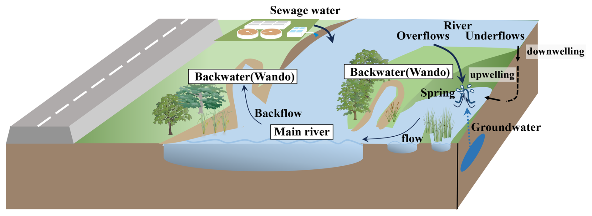
Figure 1Floodplain of urban rivers in Japan. Floodplains restricted by embankments form floodplain water bodies other than the main stream due to the effects of sedimentation and erosion. Backwaters are formed in accordance with the main stream being supplied water from river backwater, underflow/overflow water from upstream, and groundwater from the surrounding area. Some graphical symbols used in this figure were obtained from the IAN Symbol Libraries and modified by the authors.
We hypothesized that the complex contribution of abundant unconfined groundwater and fast-flowing urban rivers to floodplain waters drives water-quality-forming mechanisms that differ from those in large continental rivers. Therefore, this study focused on the Tama River, which flows through the suburbs of Tokyo, Japan, and examined the hydrological connectivity between river water and surrounding groundwater by using multiple geochemical tracers in several floodplain water bodies We examined the impact of backwaters on river ecosystems by investigating the dynamics of nutrients, including their sources and the supply processes influenced by biogeochemical processes, as well as the resulting concentrations and composition.
2.1 Study site
The target river, the Tama River, flows through the Kanto region of Japan (river length: 138 km, watershed area: 1240 km2, average flow rate: 20.9 m3 s−1) and mainly flows through urban areas of Tokyo. The river basin population exceeds 4 million, and approximately 34 % of the basin is an urban area (Fig. 2a). The Kanto region has a humid subtropical climate, with rainfall concentrated in the rainy summer seasons from June to September. River flow generally increases in these months and decreases from November to February (Fig. 2c). The survey area is located in the middle reaches of the Tama River, where effluent from five sewage treatment plants flows into the river.
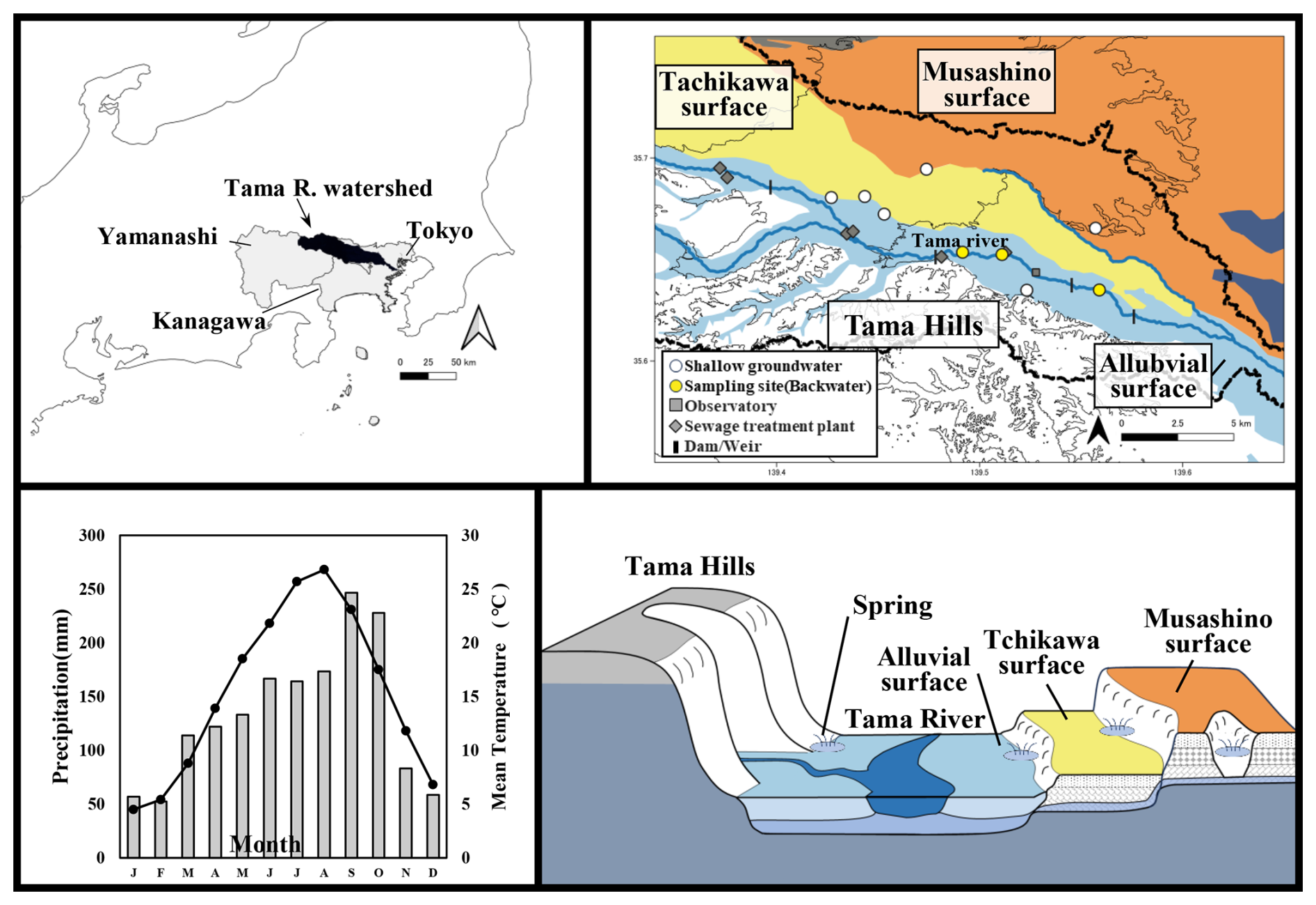
Figure 2(a) The watershed of the target river, the Tama River. (b) The sampling locations (white circles and yellow triangles), public observatory (gray squares), sewage treatment plants (blue diamonds), and dams and weirs (black bars) in the Tama River. (c) The monthly average temperature (line graph) and precipitation (bar graph) from 1991 to 2020 at meteorological observation stations near the survey sites. (d) A schematic diagram showing the alluvial fan and hilly terrain cross-sections in the study area; the colors correspond to those in (b).
The northern portion of the study area includes the central part of the alluvial fan formed by the Tama River. The alluvial fan area is characterized by a surface loam layer, with a highly permeable gravel layer beneath, resulting in abundant shallow groundwater. The shallow groundwater flows in a fan-shaped pattern from west to east, originating at the top of the alluvial fan (Shimano, 1994; Yamanaka, 2012). Groundwater levels in the area have been shown to flow southeastward and discharge into the Tama River (Hosono, 2003; Shindo, 1968). It has been established that these aquifers contribute to the replenishment of a deeper, confined aquifer. This assertion is supported by several lines of evidence, including groundwater contour lines (Shindo, 1968), tritium (Shimada et al., 1994a), and stable hydrogen and oxygen isotope ratios (Shimada et al., 1994b). The Tama River's flow has river terraces along the southern periphery of the alluvial fan. The intersection of the shallow groundwater's water table with the ground surface at the base of these terraces gives rise to numerous localized springs (Ohira et al., 2003; Shimano, 1994; Ueda et al., 2000) (Fig. 2d). On the right bank of the Tama River, a hilly area rises several dozen meters above the alluvial plain; like the alluvial fan on the left bank, its surface is covered with a layer of loam. The subsurface comprises alternating layers of gravel, silt, and sand (Takano, 1994), and shallow groundwater flowing through highly permeable layers emerges at the boundary between the hilly terrain and the Tama River alluvial deposits. We selected three small backwaters (i.e., Backwater A, B, and C from upstream, Figs. 2b, 3) within a 5 km section of the middle reaches of the Tama River. Backwater A is formed by a sandbar protruding from the riverbank. The location of the springhead varies with the season; when the main river water level was high in summer, the spring point and a small river about 100 m long appeared at the upper end of the backwater (Fig. 3a, e, d). The drainage channel from a factory is located approximately 600 m upstream of the backwater. During the survey period, the drainage flowed into the floodplain, seeped underground and no surface water inflow was observed into Backwater A or the main river. Backwater B was formed by a sandbar protruding from the riverbank, similar to Backwater A. A spring point was confirmed not only at the bottom of the upper end of the backwater but also from the riverbank at a higher elevation than the main water surface (Fig. 3b, d). Since the dry channel trace continues upstream from Backwater C to the main river, it is possible that Backwater C was formed by a temporary stream during high water levels. The headwaters of Backwater C form a small river approximately 50 m long that flows into the backwater (Fig. 3c).

Figure 3Overview and the sampling points at (a) Backwater A, (b) Backwater B and a sewage treatment plant located 50 m downstream from Backwater B, and (c) Backwater C, respectively. The yellow circles indicate the survey locations, and those with the star marks indicate the spring outlets. (d) The location of two spring points at Backwater B. Backwater B1 emerges from the bottom floor, while Backwater B2 emerges from the terrace cliff. View upstream of Backwater A in (e) dry season and (f) rainy season. The backwater area extend upstream due to the rise in water level after April. Base maps in (a)–(c) were obtained from © Google Maps (© Google, Map data © Google, Maxar Technologies, 2025). Image was cropped and annotated with sampling sites.
Water samples were collected at each backwater and adjacent river mainstream approximately once a month from February to November 2022. At each site and sampling occasion, water was collected and subsampled into three separate bottles. At each backwater, water was collected directly from the spring if it was visible, otherwise from the vicinity of the upstream end. If more than one spring was found (e.g., on the bottom floor and at the terrace cliffs), water samples were collected at both locations to verify the contribution of different water sources. The water samples were immediately filtered through a 0.2 µm cellulose acetate filter (CS020AS, ADVANTEC, Japan) for analysis of stable hydrogen and oxygen isotope ratios in water (δ2H–H2O, δ18O–H2O), and through a 0.45 µm cellulose acetate filter (CS045AS, ADVANTEC, Japan) for analysis of nutrient, dissolved ions, and stable nitrogen and oxygen isotope ratios in nitrate (δ15N–NO3, δ18O–NO3), and then stored frozen or refrigerated until analysis. The water for 222Rn analysis was collected in a 250 mL glass bottle, filling it to the brim without allowing any air bubbles to enter. To identify the water source of the spring water in the backwaters, spring water sampling was also conducted at six locations along the cliff lines around the survey site in November 2022. Rainwater was also collected from December 2021 to October 2022 within the grounds of Tokyo University of Agriculture and Technology (35.684657° N 139.483360° E). These samples were also processed in the same manner as above. Dissolved oxygen (DO), water temperature (Multi 3510 IDS, WTW, Germany), pH (HORIBA D-55, Horiba, Japan), and electrical conductivity (EC) (HORIBA ES-71, Horiba, Japan) were measured in the field. In November 2022, the concentration of colorimetric dissolved organic matter (CDOM) was measured using a CDOM sensor (Cyclops-7-Logger, Tuner Designs, USA), which had a resolution of 0.5 ppb and a detection limit of 3.0 ppb based on factory calibration (Khamis et al., 2015), by submerging the logger in water collected in a bucket for 10 minutes. River flow and water quality data at the Ishihara (35.642695° N 139.527151° E) and Tama suidobashi (35.625582° N 139.569326° E) observatories were obtained from the public database of the Ministry of Land, Infrastructure, Transport and Tourism. We also used weather data from the Fuchu Observatory (35.684254° N 139.484085° E) published by the Japan Meteorological Agency.
2.2 Chemical analyses
The major nutrients including PO, NH and dissolved silicate (DSi) were colorimetrically determined by the molybdenum blue method, the indophenol blue method, and the molybdenum yellow method, respectively, using a spectrophotometer (U-1500, HITACHI). Major anions (Cl−, NO, SO) and cations (Ca2+, Mg2+, Na+, K+) were determined using an ion chromatography system (DIONEX ICS-1100 for cations and DIONEX DX-120 for anions, Dionex Corporation, USA). The sum of NO and NH was defined as dissolved inorganic nitrogen (DIN) concentration. The bicarbonate (HCO) concentration was calculated from the alkalinity using a titration method.
δ15N–NO3 and δ18O–NO3 were determined using denitrifying bacteria following Sigman et al. (2001) and Casciotti et al. (2002). In brief, NO3 was converted into nitrous oxide (N2O) by denitrifying bacteria that lack N2O-reductase activity. The N2O was purified using cryogenic trapping (Precon System Finnigan MAT, Bremen, Germany), separated chromatographically (Finnigan GasBench Thermo Fisher Scientific, Germany), and analyzed using mass spectrometry (Finnigan DeltaplusXP, Thermo Fisher Scientific, Germany). Standard materials USGS32, USGS34, and IAEA-NO-3 were used, and analytical precision for δ15N and δ18O was generally better than 0.2 ‰ and 0.6 ‰, respectively. δ2H–H2O and δ18O–H2O were analyzed using cavity ring-down spectroscopy (L2410-I, Picarro, USA). The analytical accuracy of measurements was 0.1 ‰ for δ18O and 0.8 ‰ for δ2H based on replicate measurements of a standard. The stable isotope ratios in water and NO were expressed relative to Vienna standard ocean water (V-SMOW) and atmospheric nitrogen and were calculated as follows.
Where R=2H 1H, 18O 16O or 15N 14N. Rsample and Rstandard indicate the isotope ratio (‰) of the sample and the standard material, respectively. The 222Rn was measured using RAD-H2O system that is basically a portable 250 mL Rn-emanation bottle attached to an electronic radon detector (Durridge, RAD7, USA).
2.3 Statistical analysis
Statistical analyses were performed using statistical software R ver4.4.1. Significant differences in measurement data at each location were determined using the Kruskal-Wallis test, followed by the Dunn test with the package software car, FSA, respectively, with p<0.05 considered significant. For comparisons between the two groups, the Wilcoxon rank sum test was used, and p<0.05 was considered significant. The correlation between each measurement data was calculated using Pearson's correlation coefficient with the psych package.
3.1 EC and DO variation
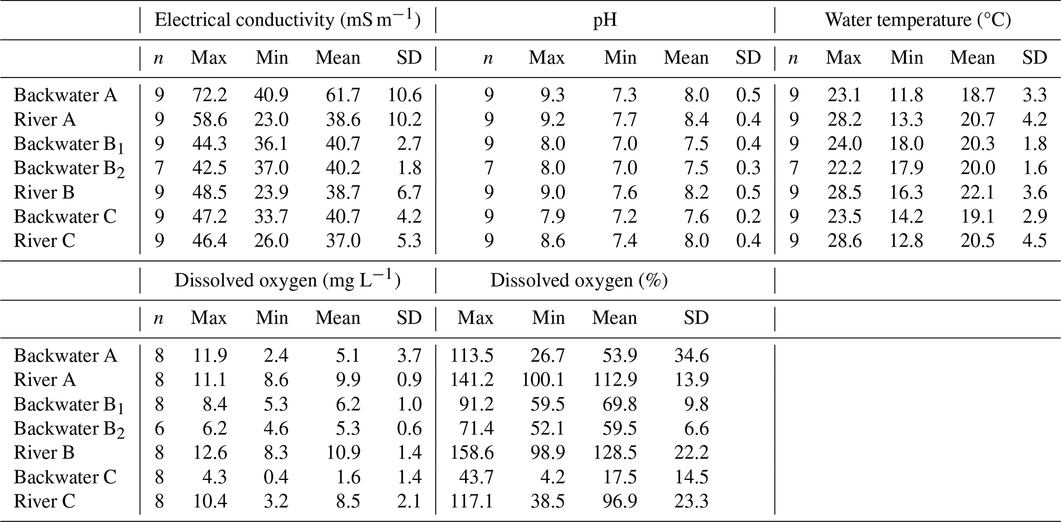
The results of DO, EC, and water temperature for each backwater and river are shown in Table 1. The water temperature in the backwater was generally cooler in summer and warmer in winter compared to that in the adjacent river. This temperature relationship has often been documented in groundwater and springs and adjacent river waters in temperate regions (e.g., Johnson et al. 2014). In February and March, during the dry winter season, no spring outlet was observed at the upstream of Backwater A, but after April, when precipitation increased, a spring outlet and a small river formed clearly (Fig. 1f). With this change in the water system, EC around the spring site increased from 44.0 ± 4.4 to 66.8 ± 5.5 mS m−1, while DO decreased from 11.2 ± 0.9 to 3.1 ± 1.0 mg L−1. On the other hand, Backwater B showed stable water quality throughout the observation period. In addition, the spring water from the terrace cliff (St. B2 in Table 1) showed slightly lower EC and DO than that from the bottom floor (St. B1 in Table 1), but no significant difference was found. In Backwater C, DO decreased clearly after April (i.e., from 4.0 ± 0.4 mg L−1 in February and March to 0.85 ± 0.54 mg L−1), indicating an anaerobic environment.
Table 1The maximum, minimum, average, and standard deviation values for electrical conductivity, pH, water temperature, and dissolved oxygen measured at each survey location from February to November 2022.
3.2 222Rn variation
The concentrations of 222Rn in shallow groundwater (i.e., 700 ± 275 dpm L−1) were about one order of magnitude higher than those in river water (i.e., 85 ± 61 dpm L−1), as in previous reports from the Kanto region in Japan (Nakano-Ohta et al., 2005; Saito and Takata, 1994). The ranges of 222Rn concentrations in Backwater A, B, and C were 204 to 617 dpm L−1, 317 to 589 dpm L−1, and 293 to 692 dpm L−1, respectively, clearly indicating higher concentrations than those in the rivers beside each backwaters. Rn concentrations in Backwater A and C increased from spring to summer and decreased in September when precipitation was heaviest, while in Backwater B they showed relatively constant activity (Table S1 in the Supplement).
3.3 δ2H–H2O and δ18O–H2O variation
The hydrogen and oxygen stable isotope ratios (δ2H and δ18O) of rainwater collected near the survey site ranged from −139 ‰ to −8.4 ‰ and −18.5 ‰ to −4.4 ‰, respectively. The local meteoric water line (LMWL) was determined by simple regression analysis as δ2H = 8.3 × δ18O + 18 (Fig. 4). The variation in δ2H and δ18O in rivers, backwaters, and shallow groundwater was confined to a narrow range (i.e., δ2H: −59 ‰ to −47 ‰ and δ18O: −9.2 ‰ to −7.6 ‰) compared to the variation in rainwater. The δ2H and δ18O values of the spring water of backwater and the adjacent river water sampled in the same month often had different values. However, in February, when no spring water was observed in Backwater A, the δ2H and δ18O values of the river and the backwater showed similar values (Table S2 in the Supplement).
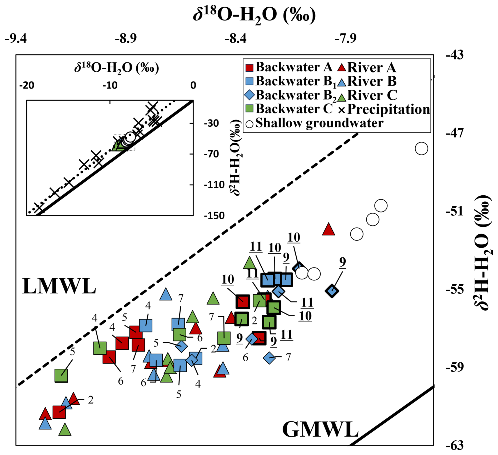
Figure 4Overall diagram (upper left) of hydrogen and oxygen isotope ratios (δ2H, δ18O) in rivers, spring water at backwater, and shallow groundwater during the survey period and enlarged diagram. GMWL and LMWL represent the Global Meteoric Water Line (δ2H = 8δ18O + 10) and the Local Meteoric Water Line (δ2H = 8.3δ18O + 18), respectively. The numbers attached to each symbol indicate the month of sampling. The data obtained in autumn is indicated by symbols enclosed in thick lines and the month of sampling underlined.
3.4 Piper diagram
The results of the Piper diagrams for each location are shown in Fig. 5. The differences in ion balance between locations of the river were minor, while they differed from those of the backwaters spring and shallow groundwater. Shallow groundwater was characterized by a high proportion of Ca and Mg and was located on the left side of the graph. During the summer period when water levels were high, Backwater A had high concentrations of Na and SO4 and these values deviated from the linear line representing the mixture of the river and shallow groundwater. On the other hand, the water quality of Backwater B and C were plotted between the river and shallow groundwater, with Backwater B showing ion balance closer to that of shallow groundwater.
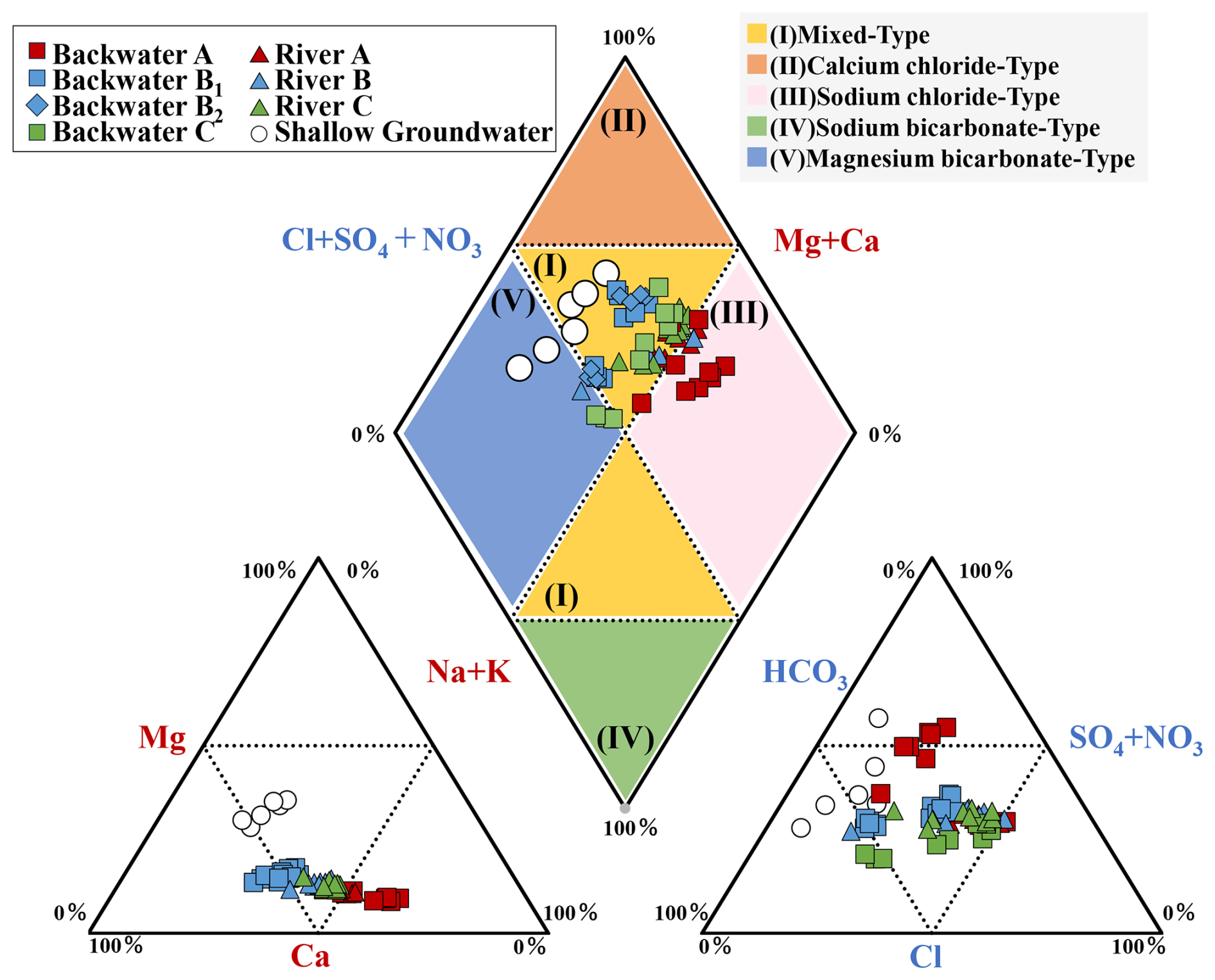
Figure 5Characteristics of each water sample plotted on a Piper diagram based on the composition of cations (red color) and anions (blue color) in each water sample. Different water chemistry phases are indicated by different background colors.
3.5 CDOM
CDOM concentrations showed a clear difference between river water (ca. 70 ppb) and shallow groundwaters (ca. 3 ppb) (Fig. 6). Furthermore, CDOM concentrations in treated sewage water were as high as 200 ppb, indicating the possibility that the contribution of rivers, shallow groundwater, and treated sewage effluent to backwater can be determined by CDOM. The CDOM concentrations in each backwaters varied from site to site, with 34 ppb in Backwater A, 7.8 ppb in Backwater B, and 24 ppb in Backwater C.
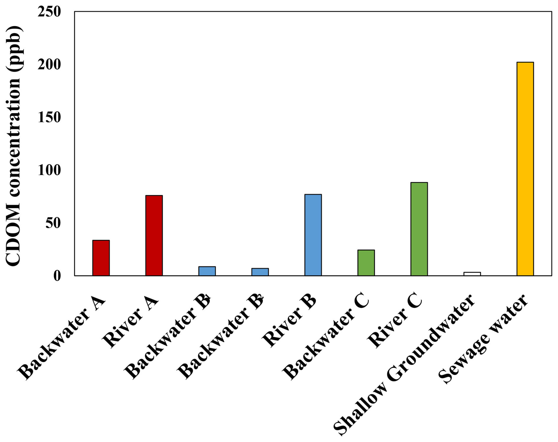
Figure 6Bar graph showing CDOM concentrations at each survey location. All data are from November 2022.
3.6 Changes in the Nutrient Environment of the backwaters
NO concentrations [NO] in rivers were high, ranging from about 100 to 300 µmol L−1 (Fig. 7a, Tables S3–S5 in the Supplement). The highest concentrations were observed in winter (February and March). At Backwater A, [NO] were as high as in the river during the winter (i.e., 298 µmol L−1 in February), but lower than in the river (i.e., 75–122 µmol L−1) when the size of the backwater was expanding (i.e., April to November). In Backwater B, [NO] fluctuated between about 120 and 230 µmol L−1, often lower than those in rivers. No apparent difference in [NO] was observed between the spring water from the bottom floor and the terrace cliffs. Unlike the other backwaters, Backwater C showed a significant decrease in [NO] after early summer, reaching as low as 18 µmol L−1 in November. The [NO] in shallow groundwater ranged from about 130 to 350 µmol L−1, with significant differences among locations, and some locations had higher concentrations than rivers and backwater springs.
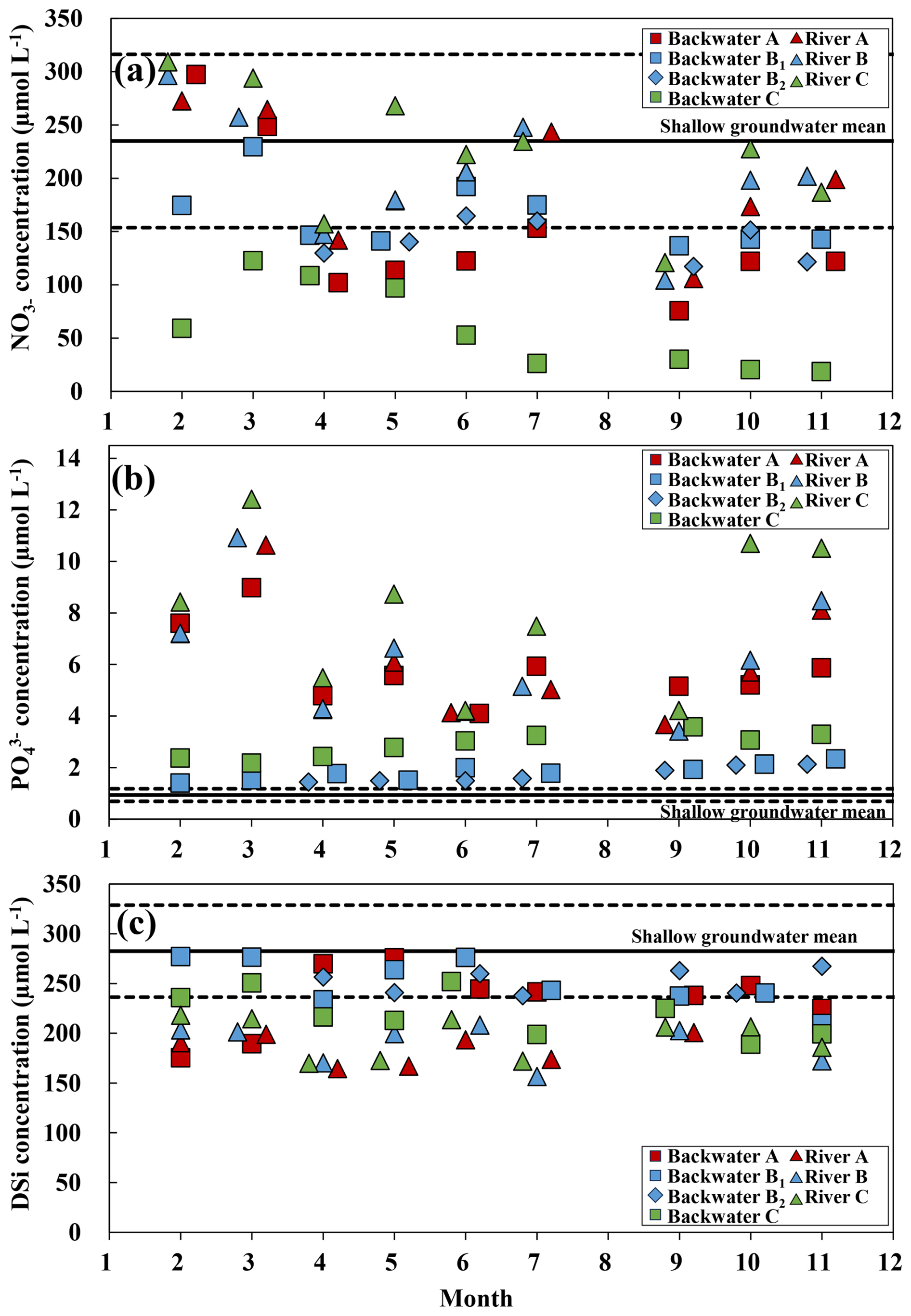
Figure 7Seasonal variation in (a) NO, (b) PO, and (c) DSi concentrations of backwater spring water and adjacent rivers. The solid line and broken lines in each graph indicate the average and standard deviation of shallow groundwater, respectively.
The PO concentration [PO] in rivers ranged from 3.4 to 12.4 µmol L−1, showing significant seasonal fluctuations (i.e., higher in February and March than the other months after April) consistent with the annual trend reported over the past 10 years in the public data for the Tama suidobashi, which is located downstream of the survey site (Table S7 in the Supplement). [PO] increased in winter and decreased from spring to summer (Fig. 7b, Tables S3–S5 in the Supplement). Similarly, seasonal variation in [PO] in Backwater A (i.e., 7.6 µmol L−1 in February, 9.0 µmol L−1 in March and 4.1 to 5.9 µmol L−1 in the other months after April) was similar to that of rivers. On the other hand, seasonal fluctuations in [PO] were small in Backwater B and C, ranging from 1.4 to 2.3 µmol L−1 and 2.2 to 3.6 µmol L−1, respectively. These values were slightly higher than [PO] in the shallow groundwater, which averaged 0.93 ± 0.23 µmol L−1.
During the survey period, DSi concentrations ([DSi]) in Backwater A and B were 175 to 276 µmol L−1 and 209 to 276 µmol L−1, respectively, which were significantly higher than those in the adjacent rivers (Dunn test, p<0.05, Fig. 7c). In Backwater C, [DSi] were also higher than those in the adjacent rivers in most seasons, ranging from 189 to 252 µmol L−1, but no statistically significant difference was observed between each river and backwater. Seasonal fluctuations were small in both rivers and backwaters, but the trends in fluctuations were similar. Most samples in shallow groundwater showed [DSi] of approximately 200 to 300 µmol L−1, except one location with a distinctly high concentration of 730 µmol L−1.
The stable isotope ratios of NO (δ15N–NO3 and δ18O–NO3) in rivers changed between 12.7 ‰ and 18.1 ‰ for δ15N–NO3 and between −2.1 ‰ and 1.4 ‰ for δ18O–NO3 (Fig. 8). Backwater A and B showed δ15N–NO3 and δ18O–NO3 values similar to those of rivers in spring (April and May). On the other hand, in autumn (October and November), 15N–NO3 and δ18O–NO3 in Backwater A showed an increasing trend, while δ15N–NO3 in Backwater B showed a decreasing trend. At Backwater C, δ15N–NO3 and δ18O–NO3 consistently showed more enriched values (i.e., 20.1 ‰–35.7 ‰ for δ15N, 6.2 ‰–15.9 ‰ for δ18O) compared with those in rivers. Shallow groundwater showed lower δ15N–NO3 and δ18O–NO3 values than those in rivers and backwater spring water, ranging from 1.7 ‰ to 6.9 ‰ for δ15N and from −1.5 ‰ to 1.7 ‰ for δ18O.
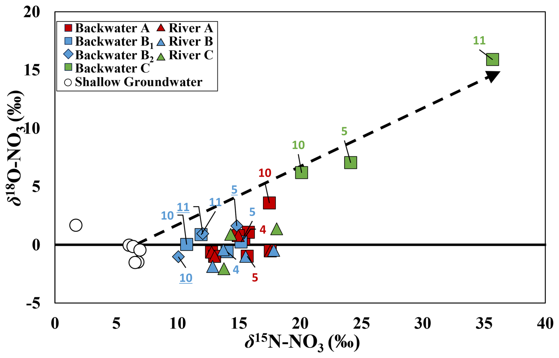
Figure 8Distribution of stable nitrogen and oxygen isotope ratios in nitrate (δ15N–NO3 and δ18O–NO3) of various water samples. The numbers shown on each symbol indicate the month of water sampling and its color indicate corresponding sampling site (the numbers for Spring B2 are underlined to distinguish them from Spring B1). The broken arrow indicates the direction in which δ15N and δ18O typically change at a ratio of 2:1 when nitrate in groundwater around the survey site undergoes denitrification.
4.1 Estimation of Water Origins and Supply Routes Using a Multi-Tracer
Previous studies on large floodplain water bodies have focused on secondary channels within floodplains (Bondar-Kunze et al., 2009; Tockner et al., 1999), floodplain water bodies maintained by backflow from slow-flowing rivers (Houser et al., 2015), and isolated water formed in floodplains (ponds, floodplain lakes; Forshay and Stanley, 2005). These studies demonstrate that the nutrients supplied by inflowing water and the nutrients released from sediments influence the nutrient dynamics in floodplain water bodies.
Many floodplains are mixed zones of river water and groundwater (Boulton et al., 2010; Hancock, 2002), and the sedimentary environment and redox conditions in the water bodies are heterogeneous (Appling et al., 2014; Gallardo, 2003; Lewandowski and Nützmann, 2010). Therefore, when considering nutrient dynamics in water bodies such as floodplains, it is essential to thoroughly examine the origin and pathways of water.
4.2 Estimated Origin of backwater Water
In this study conducted in fast-flowing urban rivers, the mixing ratio of river underflow and shallow groundwater supplied to the backwater spring water changed over time and space. Among the multiple tracers used in this study, 222Rn was effective in estimating the origin of spring water from backwater, as it exhibited higher concentrations in shallow groundwater than in rivers, consistent with previous studies (Dimova and Burnett, 2011; Ellins et al., 1990). The 222Rn concentration in the spring water of the backwaters remained at a high level from 204 to 660 dpm L−1, indicating that all the backwaters were affected by shallow groundwater. The load of 222Rn during the river underflow process in floodplains varies depending on the geology and residence time (Biehler et al., 2020; Schaper et al., 2022). It has been reported that it takes about 3 weeks for 222Rn to reach an equilibrium with minerals that generate Rn. However, the residence time of the underflow can be relatively short in our study area, because the survey area consists of gravelly sediments, and the distances between the river and backwaters are short (50–100 m). Therefore, it is considered that the influence of 222Rn loading during the underflow process is negligible.
The influence of shallow groundwater was also observed in the ion compositions. The Piper diagram (Fig. 5) shows that through the study period, the ion composition of Backwater B and C was intermediate between shallow groundwater and river water, respectively, with the composition of Backwater B being more similar to that of groundwater. Therefore, it was suggested that both Backwater B and C are formed by the mixing of river water and shallow groundwater, with Backwater B in particular being strongly influenced by shallow groundwater. On the other hand, the ion composition of Backwater A was characterized by high concentrations of Na and was slightly out of the mix of river and groundwater. In Backwater A, spring water with high electrical conductivity (EC) and high concentrations of Na+ and SO was observed as river flow increased. Subsequent surveys revealed that in the upstream section of Backwater A, industrial effluent containing far higher concentrations of Na+ and SO (Na+: approximately 11 mmol L−1, SO: approximately 7 mmol L−1, Ryotaro Ueba, unpublished data) (Fig. 3a, Table S8 in the Supplement) and CDOM (167 ppb, Ryotaro Ueba, unpublished data) were discharged into the floodplain. This suggests that seasonal increases in river flow caused the water level of underground riverwater in the floodplain to rise, resulting in a mixture of underground drainage and groundwater flowing into Backwater A.
In this study, CDOM concentrations showed clear differences between rivers, shallow groundwater, and treated sewage water (Fig. 6). The effluent from the wastewater treatment plant undergoes multiple microbial treatment processes in the circulation tanks (Dignac et al., 2000), resulting in extremely high CDOM levels, including refractory DOM. Therefore, the inflow of treated water would help maintain high CDOM concentrations in the river. CDOM concentrations being higher in river water than in groundwater was consistent with the results of our additional surveys conducted during the rainy and dry seasons, which have different river flow rates (i.e., 5.5 and 5.9 ppb in shallow groundwater, and 9.4 and 57.2 ppb in river water, during dry and wet seasons, respectively, Ryotaro Ueba, unpublished data). Therefore, the relatively low CDOM concentrations observed in spring water at backwaters are thought to reflect dilution by shallow groundwater with lower CDOM concentrations. The CDOM concentrations in both Backwater B and C were lower than those in the river, but in addition, Backwater B, which was inferred from the Piper diagram to be more strongly influenced by shallow groundwater, showed CDOM concentrations closer to those of shallow groundwater than Backwater C.
The d-value (Dansgaard, 1964), which is known to preserve the evaporation process during raincloud formation over the sea, generally shows values < 10 ‰ in summer and > 20 ‰ in winter in Japan, located in the monsoon climate zone (Waseda and Nakai, 1983). In this survey, d-values of rainwater showed a similar trend (i.e., 7.3 ‰ to 13 ‰ in rainy season, 13 ‰ to 30 ‰ in dry season) (Table S2 in the Supplement). On the other hand, the d-values for rivers, shallow groundwater, and backwaters ranged from 7.5 ‰ to 14.5 ‰ regardless of season, showing values close to those during summer precipitation. Consequently, this indicates that summer rainfall is the primary recharge source for shallow groundwater. Furthermore, in rivers, dams in the upper reaches store rainfall during the rainy season in summer to ensure domestic water supplies. This water is then discharged into the Tama River either directly or indirectly via domestic water systems throughout the year, likely contributing to the pronounced influence of summer rainfall. In fact, in the survey period, 43 % of the annual precipitation fell during the summer months (July, August, and September). Hydrogen and oxygen stable isotopes (δ2H and δ18O) in water showed altitude effects even in Tama river middle reaches, due to the higher elevation of its whole catchment area (i.e., 1021 m on average) (Inamura and Yasuhara, 2003). On the other hand, shallow groundwater in the plateau generally has relatively heavier δ2H and δ18O values than the adjacent rivers. This is because shallow groundwater is recharged by rain that falls in relatively lowland areas (i.e., about 8–50 m) compared to the Tama river whole catchment area, as also suggested by Shimada et al. (1994b).
In this study, δ2H and δ18O values at the backwater spring outlet showed a trend toward heavier values after July to September (Fig. 4). This change is consistent with the fact that most of the annual precipitation falls in summer and shallow groundwater is mainly replenished by summer rainfall, as discussed in terms of the d-value above. In our study sites, summer precipitation increased the supply of shallow groundwater, indicating that shallow groundwater became the dominant source of spring water in the backwaters.
4.3 Nutrients Dynamics in the backwaters
In floodplain water bodies, nutrients are generally supplied by overflow water and underflow water from the main river (e.g., overflow during floods: Heiler et al., 1995; Knowlton and Jones, 1997; underflow: Tockner et al. 1999). Furthermore, it has been clarified that the effect of nutrient dilution occurs due to the inflow of groundwater, where nutrients are removed by denitrification and adsorption on minerals (Bornette and Amoros, 1991; Carbiener et al., 1990). However, recent studies have often reported that groundwater can act as a source of nitrate and phosphate, influenced by surrounding land use and contamination (e.g., NO: Arauzo et al., 2011; PO: Holman et al., 2010; Lewandowski et al., 2015), as well as by geology (PO: Huang et al., 2020). Therefore, when considering the nutrient dynamics of backwaters, it is necessary to take into account the effects of nutrients transported by shallow groundwater.
Nitrate concentration ([NO]) in groundwater ranged from 130 to 350 µmol L−1, as high as in river water, but δ15N in NO3 (δ15N–NO3) in groundwater (i.e., 1.7 ‰–6.9 ‰) was lower than that in river water (i.e., 12.7 ‰–18.1 ‰) affected by treated sewage. Therefore, [NO] in groundwater may be more influenced by chemical fertilizers applied to fields rather than leaking sewage pipes. As 222Rn and CDOM were used as indicators to clearly distinguish the contribution of shallow groundwater and river water to backwater (see above), δ15N–NO3 could also be used to analyze the source of NO observed in backwater. On the other hand, in the spring water of Backwater A and C, and for [NO] in Backwater C in particular, dissolved oxygen (DO) and NO decreased significantly from spring to summer (Fig. 7), while δ15N–NO3 and δ18O–NO3 increased at a ratio of approximately 2:1 (Fig. 8). These findings are consistent with phenomena observed during denitrification and suggest that significant denitrification likely occurred (Kendall et al., 2007). The formation of anaerobic conditions and the activation of denitrification in floodplain aquifers have been reported in numerous studies (Bernard-Jannin et al., 2017; Obana et al., 2011). Denitrification in floodplains is influenced not only by a decrease in DO but also by other factors such as water quality parameters (organic matter content, water temperature, pH, etc.), groundwater level, soil particle size, and vegetation along groundwater flow paths (e.g., soil pH: Kaden et al., 2021; topography and soil particle size: Pinay et al., 2000; soil moisture: Pinay et al., 2007; groundwater level: McCarty et al., 2006). Previous studies of floodplains suggested that groundwater flow and water-level conditions contributed to locally elevated denitrification activity (McClain et al., 2003; Vidon and Hill, 2004; Kellogg et al., 2005). [NO] in backwater springs varies by location within a relatively small study area (a 5 km radius), despite the relatively stable [NO] in rivers and groundwater, suggesting that the sedimentary environments surrounding these backwaters differ due to factors such as river meandering. Therefore, to evaluate denitrification capacity at each site and identify its determining factors, it is necessary to understand the floodplain subsurface in three dimensions from the perspectives of hydrology and sediment composition.
Due to the urbanization around the Tama River, we predicted that shallow groundwater would be contaminated with PO in the same way as NO, but in fact, PO concentration ([PO]) in shallow groundwater in the middle reaches was only about 1–2 µmol L−1 higher than [PO] in upstream water in Tokyo (Wakamatsu et al., 2006). The reason for the discrepancy between [NO] and [PO] in shallow groundwater may be attributed to volcanic ash-derived sediments (i.e., Kanto Loam layer) with high PO adsorption capacity (Abdelwaheb et al., 2019; Uchida et al., 2022). As a result, the [PO] in backwater reflects the influence of supply from river water (i.e., ca. 6.8 µmol L−1) and dilution by shallow groundwater (i.e., ca. 0.9 µmol L−1) (Fig. 7b). This is consistent with the relative order of [PO] in each backwaters (i.e., Backwater A: 5.9 µmol L−1 > Backwater C: 2.9 µmol L−1 > Backwater B: 1.8 µmol L−1 on average) corresponding to the relative CDOM concentrations (i.e., Backwater A: 34 ppb > Backwater C: 24 ppb > Backwater B: 7.8 ppb), which serve as an indicator of river water mixing intensity. Additionally, even in the spring water at Backwater C, where anaerobic conditions had formed, there were no significant increases in [PO], although the release of PO and Fe2+ from iron-bound phosphorus has often been reported in anaerobic environments (Carlyle and Hill, 2001). These results suggest that the PO load in the floodplain groundwater is highly limited, and the backwater is likely to exhibit consistently lower [PO] than rivers.
The concentration of DSi [DSi] in backwaters (i.e., 175–277 µmol L−1) was higher than that in rivers in almost all seasons (i.e., 157–218 µmol L−1), with an average of 54 µmol L−1 higher (Fig. 7c). This suggests the possibility of inflow of groundwater with higher [DSi] (i.e., 231–730 µmol L−1) affected by geological factors (Asano et al., 2003), and the supply of shallow groundwater to the backwaters may form an ecosystem with higher [DSi] that is different from those of rivers throughout the year.
4.4 The Environment of the backwater from the Perspective of Spring Water
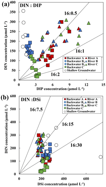
From a stoichiometric perspective in relation to aquatic phytoplankton dynamics, the backwater studied here may exhibit significant differences in phytoplankton dynamics due to seasonal and backwater-specific variations in nutrient concentrations and compositions (Filstrup et al., 2016). Therefore, the nutrient concentrations and composition of the water samples obtained in this study were plotted (Fig. 9a, b) and discussed with reference to the Redfield ratio (C : Si : N : P ), which has commonly been used in ocean studies (Brzezinski, 1985; Redfield, 1934).
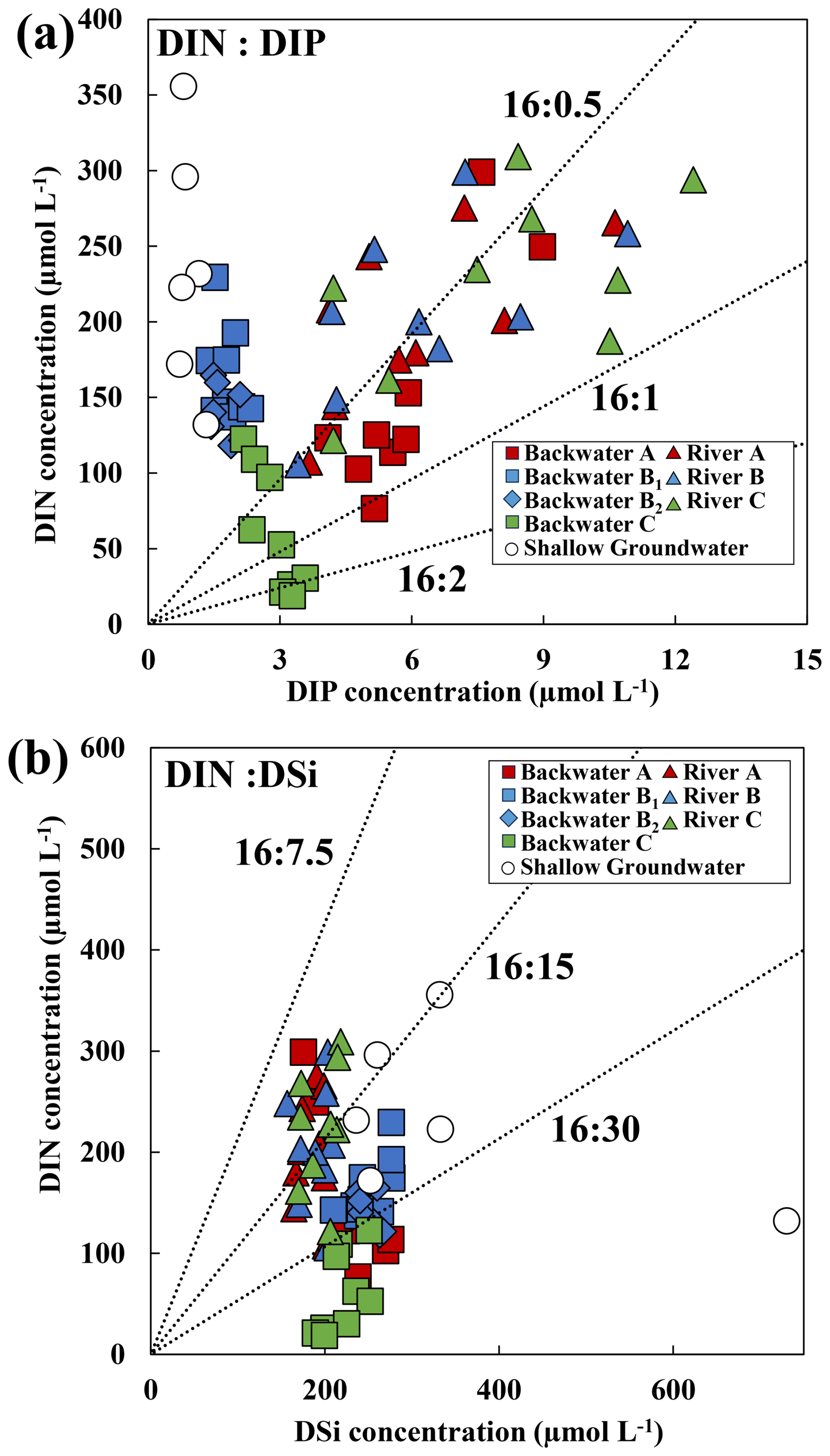
Figure 9(a) DIN and PO concentrations and (b) DIN and DSi concentrations of spring water in each backwaters, river water, and shallow groundwater plotted with dotted lines indicating typical composition ratios. The numbers shown on each symbol indicate the month of water sampling and its color indicate corresponding sampling site (the numbers for Spring B2 are underlined to distinguish them from Spring B1).
The N : P ratio of nutrients was greater than 16:1 in rivers and spring water at Backwater A and B, especially in Backwater B, ranging from 60 to as high as 150. On the other hand, in Backwater C, the N : P ratio decreased significantly from approximately 56:1 to 6:1 seasonally due to the reduction of NO through denitrification. In backwaters such as Backwater B and C, where the contribution from shallow groundwater recharge is significant, [PO] remained consistently low, while [NO] fluctuated probably due to seasonal changes in microbial activity, fertilization, and river influence. Consequently, the N : P ratio of nutrients in spring water in backwaters may vary significantly depending on the season. On the other hand, in Backwater A, where CDOM concentrations were high, suggesting much greater contribution from river water, the N : P ratio of nutrients tended to be relatively stable. This is likely because urban rivers are influenced by treated wastewater-derived nutrients with a relatively stable N : P ratio throughout the year. Since treated wastewater is mixed with the river base flow containing low concentrations of nutrients, the nutrient concentrations in the river fluctuate seasonally depending on the mixing ratio, keeping the N : P ratio almost stable. In our study area, overall, backwaters were recharged by shallow groundwater, river water, and occasionally drainage water, with specific nutrient characteristics. This leads to fluctuations in N and P concentrations and/or the variation in the N : P ratio, which may result in the formation of diverse phytoplankton communities (Kovalenko et al., 2017; Roozen et al., 2008; Unrein, 2002).
The DSi concentration [DSi] in the Tama River was around 340 µmol L−1 prior to 1950, slightly higher than the average (316 µmol L−1) for other major rivers in Japan (Kobayashi, 1961). Additionally, the average [DSi] in the Tama River decreased to about 300 µmol L−1 around 2005 (Inoue and Akagi, 2006), and has further decreased to about 190 µmol L−1 in 2022 (this study). Structures such as dams and weirs that disrupt the continuity of rivers cause DSi to be taken up by phytoplankton and precipitate as particulate silicon, thereby inhibiting the transport of DSi downstream (Humborg et al., 1997; Maavara et al., 2020; Wei et al., 2015; Yang et al., 2018). The construction of multiple weirs on the Tama River may also be hindering DSi transport and causing low concentrations in the main river channel. In addition, [DSi] in rivers and spring areas also decrease significantly due to the direct supply of rainwater with lower [DSi] (i.e., below the detection limit). The [DSi] in shallow groundwater is at least 30 µmol L−1 higher than that of rivers, and the DIN : DSi of spring water influenced by groundwater was clearly different from that of rivers, being up to 16:30 or higher (Fig. 9b). Many studies have reported that DSi is one of the factors limiting diatom proliferation in freshwater ecosystems (Egge and Aksnes, 1992; Egge and Jacobsen, 1997; Justić et al., 1995; Turner et al., 1998). In backwater, the inflow of shallow groundwater may create an environment favorable to diatoms compared to rivers, potentially leading to changes in the composition of phytoplankton communities.
We hypothesized that water quality in backwaters within the mid-reaches of urban rivers varies due to complex contributions from river water and groundwater, influenced by surrounding land use, geology, and topography. Therefore, in this study, we used multiple geochemical tracers (i.e., ion balance, CDOM, 222Rn, δ2H and δ18O–H2O, δ15N and δ18O–NO3) to estimate the origin and pathways of water and the associated dynamics of growth-limiting nutrients such as N, P, and Si. The results from each tracer suggested that backwaters consist of mixtures of urban river water and groundwater, with mixing ratios varying spatiotemporally, even within relatively short river sections. PO and DSi concentrations in backwaters were influenced by inputs from urban rivers and shallow groundwater, which exhibited contrasting nutrient signatures (i.e., high [PO] and low [DSi] in urban rivers, and low [PO] and high [DSi] in groundwater). Although DIN concentrations were similar in urban rivers and shallow groundwater, analyses of δ15N and δ18O–NO3, together with seasonal variations in [NO] and dissolved oxygen (DO), demonstrated the sources of NO in backwaters and its removal via denitrification in floodplain groundwater. As a result, the use of multiple geochemical tracers revealed that nutrient dynamics in backwaters are controlled by the contribution of urban river water and shallow groundwater in varying proportions, and additionally by microbial activity in the floodplain, thereby contributing to water-quality diversification within the river ecosystem.
The datasets generated and analyzed during this study are available in the Zenodo repository: https://doi.org/10.5281/zenodo.20115076 (Ueba and Umezawa, 2026).
The supplement related to this article is available online at https://doi.org/10.5194/bg-23-6299-2026-supplement.
R.U. designed the study with guidance from Y.U. R.U. conducted the fieldwork, performed the data analysis, and wrote the manuscript. Y.U. supervised the research and revised the manuscript.
The contact author has declared that neither of the authors has any competing interests.
Publisher's note: Copernicus Publications remains neutral with regard to jurisdictional claims made in the text, published maps, institutional affiliations, or any other geographical representation in this paper. The authors bear the ultimate responsibility for providing appropriate place names. Views expressed in the text are those of the authors and do not necessarily reflect the views of the publisher.
We would like to express our gratitude to Dr. M, Yoh. (TUAT), Dr. S, Nakada. (NIES), and the staff of the Keihin River Office of the Ministry of Land, Infrastructure, Transport and Tourism for their advice and equipment loans in conducting this study. Isotope ratio analysis was conducted with technical support from Dr. I, Tayasu., Dr. C, Yoshimizu., and Dr. S, Yabusaki., and was supported by the Joint Research Grant for the Environmental Isotope Study and “Towards Sustainable Nitrogen Use Connecting Human Society and Nature” Project (No. RIHN14200156) of the Research Institute for Humanity and Nature (RIHN:a constituent member of NIHU). This research was supported by the Sasakawa Science Research Grant (2022-3043), the River Fund of The River Foundation, Japan (2024-5311-027), JST SPRING (JPMJSP2116), and JSPS KAKENHI Grant Number JP22H05202, JP23K25421.
This research has been supported by the Research Institute for Humanity and Nature (grant no. RIHN14200156), the Japan Society for the Promotion of Science (grant nos. JP22H05202 and JP23K25421), the Sasakawa Science Research Grant (grant no. 2022-3043), the River Fund of The River Foundation, Japan (grant no. 2024-5311-027), and JST SPRING (grant no. JPMJSP2116).
This paper was edited by Lishan Ran and reviewed by Jiaxu Han and two anonymous referees.
Abdelwaheb, M., Jebali, K., Dhaouadi, H., and Dridi-Dhaouadi, S.: Adsorption of nitrate, phosphate, nickel and lead on soils: Risk of groundwater contamination, Ecotoxicol. Environ. Saf., 179, 182–187, https://doi.org/10.1016/j.ecoenv.2019.04.040, 2019.
Amoros, C. and Roux, A. L.: Interactions between water bodies within floodplains of large rivers: function and development of connectivity, in: Connectivity in Landscape Ecology. Proceedings of the 2nd International Seminar of the “International Association for Landscape Ecology” (IALE) in Münster, edited by: Schreiber, K.-F., Münstersche Geographische Arbeiten, 125–130, ISBN 13 978-3-506-73229-3, 1988.
Appling, A. P., Bernhardt, E. S., and Stanford, J. A.: Floodplain biogeochemical mosaics: A multidimensional view of alluvial soils, J. Geophys. Res. Biogeosci., 119, 1538–1553, https://doi.org/10.1002/2013JG002543, 2014.
Arauzo, M., Valladolid, M., and Martínez-Bastida, J. J.: Spatio-temporal dynamics of nitrogen in river-alluvial aquifer systems affected by diffuse pollution from agricultural sources: Implications for the implementation of the Nitrates Directive, J. Hydrol. (Amst)., 411, 155–168, https://doi.org/10.1016/j.jhydrol.2011.10.004, 2011.
Asano, Y., Uchida, T., and Ohte, N.: Hydrologic and geochemical influences on the dissolved silica concentration in natural water in a steep headwater catchment, Geochim. Cosmochim. Acta, 67, 1973–1989, https://doi.org/10.1016/S0016-7037(02)01342-X, 2003.
Bernard-Jannin, L., Sun, X., Teissier, S., Sauvage, S., and Sánchez-Pérez, J. M.: Spatio-temporal analysis of factors controlling nitrate dynamics and potential denitrification hot spots and hot moments in groundwater of an alluvial floodplain, Ecol. Eng., 103, 372–384, https://doi.org/10.1016/j.ecoleng.2015.12.031, 2017.
Biehler, A., Chaillou, G., Buffin-Bélanger, T., and Baudron, P.: Hydrological connectivity in the aquifer–river continuum: impact of river stages on the geochemistry of groundwater floodplains, J. Hydrol. (Amst)., 590, https://doi.org/10.1016/j.jhydrol.2020.125379, 2020.
Bondar-Kunze, E., Preiner, S., Schiemer, F., Weigelhofer, G., and Hein, T.: Effect of enhanced water exchange on ecosystem functions in backwaters of an urban floodplain, Aquat. Sci., 71, 437–447, https://doi.org/10.1007/s00027-009-0101-7, 2009.
Bornette, G. and Amoros, C.: Aquatic vegetation and hydrology of a braided river floodplain, J. Veg. Sci., 2, 497–512, https://doi.org/10.2307/3236032, 1991.
Boulton, A. J., Datry, T., Kasahara, T., Mutz, M., and Stanford, J. A.: Ecology and management of the hyporheic zone: Stream-groundwater interactions of running waters and their floodplains, J. North Am. Benthol. Soc., 29, 26–40, https://doi.org/10.1899/08-017.1, 2010.
Brunke, M.: Floodplains of a regulated southern alpine river (Brenno, Switzerland): Ecological assessment and conservation options, Aquat. Conserv., 12, 583–599, https://doi.org/10.1002/aqc.544, 2002.
Brunke, M., Hoehn, E., and Gonser, T.: Patchiness of river–groundwater interactions within two floodplain landscapes and diversity of aquatic invertebrate communities, Ecosystems, 6, 707–722, https://doi.org/10.1007/PL00021501, 2003.
Brzezinski, M. A.: The Si: C: N ratio of marine diatoms: interspecific variability and the effect of some environmental variables, J. Phycol., 21, 347–357, https://doi.org/10.1111/j.0022-3646.1985.00347.x, 1985.
Carbiener, R., Trémolières, M., Mercier, J. L., and Ortscheit, A.: Aquatic macrophyte communities as bioindicators of eutrophication in calcareous oligosaprobe stream waters (Upper Rhine plain, Alsace), Vegetation, 86, 71–88, https://doi.org/10.1007/BF00045135, 1990.
Carlyle, G. C. and Hill, A. R.: Groundwater phosphate dynamics in a river riparian zone: effects of hydrologic flowpaths, lithology and redox chemistry, J. Hydrol. (Amst)., 247, 151–168, https://doi.org/10.1016/S0022-1694(01)00375-4, 2001.
Casciotti, K. L., Sigman, D. M., Hastings, M. G., Böhlke, J. K., and Hilkert, A.: Measurement of the oxygen isotopic composition of nitrate in seawater and freshwater using the denitrifier method, Anal. Chem., 74, 4905–4912, https://doi.org/10.1021/ac020113w, 2002.
Dansgaard, W.: Stable isotopes in precipitation, Tellus A: Dyn. Meteorol. Oceanogr., 16, 436, https://doi.org/10.3402/tellusa.v16i4.8993, 1964.
Denda, M., Yamashita, S., Ozawa, T., and Shimatani, Y.: Backwaters and fish community – on environmental factors affecting fish community in backwaters, Jpn. J. Ecol., 52, 287–294, https://doi.org/10.18960/seitai.52.2_287, 2002 (in Japanese with English abstract).
Denda, M., Amano, K., and Tuzimoto, T.: A study on contribution of temporary water area to the diversity of fish community and physical environment which influences the contribution, Japanese Journal of JSCE G, 62, 340–358, https://doi.org/10.2208/jscejg.62.340, 2006 (in Japanese with English abstract).
Dignac, M. F., Ginestet, P., Rybacki, D., Bruchet, A., Urbain, V., and Scribe, P.: Fate of wastewater organic pollution during activated sludge treatment: nature of residual organic matter, Water Res., 34, 4185–4194, https://doi.org/10.1016/S0043-1354(00)00195-0, 2000.
Dimova, N. T. and Burnett, W. C.: Evaluation of groundwater discharge into small lakes based on the temporal distribution of radon-222, Limnol. Oceanogr., 56, 486–494, https://doi.org/10.4319/lo.2011.56.2.0486, 2011.
Egge, J. K. and Aksnes, D. L.: Silicate as regulating nutrient in phytoplankton competition, Mar. Ecol. Prog. Ser., 83, 281–289, https://doi.org/10.3354/MEPS083281, 1992.
Egge, J. K. and Jacobsen, A.: Influence of silicate on particulate carbon production in phytoplankton, Mar. Ecol. Prog. Ser., 147, 219–230, https://doi.org/10.3354/MEPS147219, 1997.
Ellins, K. K., Roman-Mas, A., and Lee, R.: Using 222Rn to examine groundwater/surface discharge interaction in the Rio Grande de Manati, Puerto Rico, J. Hydrol. (Amst)., 115, 319–341, https://doi.org/10.1016/0022-1694(90)90212-G, 1990.
Filstrup, C. T., Heathcote, A. J., Kendall, D. L., and Downing, J. A.: Phytoplankton taxonomic compositional shifts across nutrient and light gradients in temperate lakes, Inland Waters, 6, 234–249, https://doi.org/10.5268/IW-6.2.939, 2016.
Forshay, K. J. and Stanley, E. H.: Rapid nitrate loss and denitrification in a temperate river floodplain, Biogeochemistry, 75, 43–64, https://doi.org/10.1007/s10533-004-6016-4, 2005.
Galat, D. L., Kubisiak, J. F., Hooker, J. B., and Sowa, L. M.: Geomorphology, distribution and connectivity of lower Missouri River floodplain waterbodies scoured by the flood of 1993, Verh. Int. Ver. Theor. Angew. Limnol., 26, 869–878, https://doi.org/10.1080/03680770.1995.11900842, 1997.
Gallardo, A.: Spatial Variability of Soil Properties in a Floodplain Forest in Northwest Spain, Ecosystems, 6, 564–576, https://doi.org/10.1007/s10021-003-0198-9, 2003.
Gmitrowicz-Iwan, J., Ligeȩza, S., Pranagal, J., Smal, H., and Olenderek, H.: Small floodplain reservoirs in the face of climate change – sink or source of nutrients?, Water, 12, 1–15, https://doi.org/10.3390/w12123423, 2020.
Gooddy, D. C., Macdonald, D. M. J., Lapworth, D. J., Bennett, S. A., and Griffiths, K. J.: Nitrogen sources, transport and processing in peri-urban floodplains, Sci. Tot. Environ., 494–495, 28–38, https://doi.org/10.1016/j.scitotenv.2014.06.123, 2014.
Hancock, P. J.: Human impacts on the stream-groundwater exchange zone, Environ. Manage., 29, 763–781, https://doi.org/10.1007/s00267-001-0064-5, 2002.
Heiler, G., Hein, T., Schiemer, F., and Bornette, G.: Hydrological connectivity and flood pulses as the central aspects for the integrity of a river‐floodplain system, Reg. Riv.: Res. Mgmt., 11, 351–361, 1995.
Holman, I. P., Howden, N. J. K., Bellamy, P., Willby, N., Whelan, M. J., and Rivas-Casado, M.: An assessment of the risk to surface water ecosystems of groundwater P in the UK and Ireland, Sci. Tot. Environ., 408, 1847–1857, https://doi.org/10.1016/j.scitotenv.2009.11.026, 2010.
Hosono, Y.: A geographical study on the groundwater table database in Tokyo area, Memoirs of Nara University, 31, 147–166, 2003 (in Japanese).
Houser, J. N., Bartsch, L. A., Richardson, W. B., Rogala, J. T., and Sullivan, J. F.: Ecosystem metabolism and nutrient dynamics in the main channel and backwaters of the Upper Mississippi River, Freshw. Biol., 60, 1863–1879, https://doi.org/10.1111/fwb.12617, 2015.
Huang, G., Liu, C., Zhang, Y., and Chen, Z.: Groundwater is important for the geochemical cycling of phosphorus in rapidly urbanized areas: a case study in the Pearl River Delta, Environ. Pollut., 260, 114079, https://doi.org/10.1016/J.ENVPOL.2020.114079, 2020.
Humborg, C., Ittekkot, V., Cociasu, A., and Bodungen, B. V.: Effect of Danube River dam on Black Sea biogeochemistry and ecosystem structure, Nature, 386, 385–388, https://doi.org/10.1038/386385A0, 1997.
Inamura, A. and Yasuhara, M.: Hydrogen and oxygen isotopic rations of river water in the Kanto plain and surrounding mountainous regions, Japan, J. Jpn. Assoc. Hydrol. Sci., 33, 115–124, https://doi.org/10.4145/jahs.33.115, 2003 (in Japanese with English abstract).
Inoue, N. and Akagi, T.: The influence of the dam and sewage treatment plants on the silicon budget of the Tamagawa River, Chikyukagaku, Geochemistry, 40, 137–145, 2006.
Johnson, M. F., Wilby, R. L., and Toone, J. A.: Inferring air-water temperature relationships from river and catchment properties, Hydrol. Process., 28, 2912–2928, https://doi.org/10.1002/hyp.9842, 2014.
Junk, W. J., Peter B. Bayley, and Richard E. Sparks: The flood pulse concept in river-floodplain systems, Can. Spec. Publ. Fish. Aquat. Sci., 106, 110–127, 1989.
Justić, D., Rabalais, N. N., Turner, R. E., and Dortch, Q.: Changes in nutrient structure of river-dominated coastal waters: stoichiometric nutrient balance and its consequences, Estuar. Coast. Shelf Sci., 40, 339–356, https://doi.org/10.1016/S0272-7714(05)80014-9, 1995.
Kaden, U. S., Fuchs, E., Geyer, S., Hein, T., Horchler, P., Rupp, H., Scholz, M., Schulz-Zunkel, C., and Weigelhofer, G.: Soil characteristics and hydromorphological patterns control denitrification at the floodplain scale, Front. Earth Sci. (Lausanne), 9, https://doi.org/10.3389/feart.2021.708707, 2021.
Kayaba, Y., Denda, M., and Shimatani, Y.: The basic study the factors that cause the creation of Wando and their characteristics at Chikuma river, Environ. Syst. Res., 25, 611–616, https://doi.org/10.2208/proer1988.25.611, 1997 (in Japanese with English abstract).
Kellogg, D. Q., Gold, A. J., Groffman, P. M., Addy, K., Stolt, M. H., and Blazejewski, G.: In situ ground water denitrification in stratified, permeable soils underlying riparian wetlands, J. Environ. Qual., 34, 524–533, https://doi.org/10.2134/jeq2005.0524, 2005.
Kendall, C., Elliott, E. M., and Wankel, S. D.: Tracing anthropogenic inputs of nitrogen to ecosystems, in: Stable Isotopes in Ecology and Environmental Science, edited by: Michener, R. H. and Lajtha, K., Blackwell Publishing, 375–449, https://doi.org/10.1002/9780470691854.ch12, 2007.
Keruzoré, A. A., Willby, N. J., and Gilvear, D. J.: The role of lateral connectivity in the maintenance of macrophyte diversity and production in large rivers, Aquat. Conserv., 23, 301–315, https://doi.org/10.1002/aqc.2288, 2013.
Khamis, K., Sorensen, J. P. R., Bradley, C., Hannah, D. M., Lapworth, D. J., and Stevens, R.: In situ tryptophan-like fluorometers: assessing turbidity and temperature effects for freshwater applications, Environ. Sci. Process. Impacts, 17, 740–752, https://doi.org/10.1039/C5EM00030K, 2015.
Kimizuka, Y.: A study on transition and fishfauna of artificial wand-pool in the middle reaches of Tama-gawa River, Environ. Eng. Res., 35, 285–293, https://doi.org/10.11532/proes1992.35.285, 1998 (in Japanese with English abstract).
Knowlton, M. E. and Jones, J. R.: Trophic status of Missouri River floodplain lakes in relation to basin type and connectivity, Wetlands, 17, 468–475, 1997.
Kobayashi, J.: A chemical study on the average quality and characteristics of river waters of Japan, H. Agric. Sci., 48, 63–101, 1961.
Kovalenko, K. E., Reavie, E. D., Allan, J. D., Cai, M., Smith, S. D. P., and Johnson, L. B.: Pelagic phytoplankton community change-points across nutrient gradients and in response to invasive mussels, Freshw. Biol., 62, 366–381, https://doi.org/10.1111/fwb.12873, 2017.
Lewandowski, J. and Nützmann, G.: Nutrient retention and release in a floodplain's aquifer and in the hyporheic zone of a lowland river, Ecol. Eng., 36, 1156–1166, https://doi.org/10.1016/j.ecoleng.2010.01.005, 2010.
Lewandowski, J., Meinikmann, K., Nützmann, G., and Rosenberry, D. O.: Groundwater – the disregarded component in lake water and nutrient budgets, Part 2: Effects of groundwater on nutrients, Hydrol. Process., 29, 2922–2955, https://doi.org/10.1002/hyp.10384, 2015.
Maavara, T., Chen, Q., Van Meter, K., Brown, L. E., Zhang, J., Ni, J., and Zarfl, C.: River dam impacts on biogeochemical cycling, Nat. Rev. Earth Environ., 1, 103–116, https://doi.org/10.1038/s43017-019-0019-0, 2020.
McCarty, G. W., Mookherji, S., and Angier, J. T.: Characterization of denitrification activity in zones of groundwater exfiltration within a riparian wetland ecosystem, Biol. Fertil. Soils, 43, 691–698, https://doi.org/10.1007/s00374-006-0151-0, 2006.
McClain, M. E., Boyer, E. W., Dent, C. L., Gergel, S. E., Grimm, N. B., Groffman, P. M., Hart, S. C., Harvey, J. W., Johnston, C. A., Mayorga, E., McDowell, W. H., and Pinay, G.: Biogeochemical hot spots and hot moments at the interface of terrestrial and aquatic ecosystems, Ecosystems, 6, 301–312, https://doi.org/10.1007/s10021-003-0161-9, 2003.
Minagawa, T., Okamura, M., Onikura, N., Hayashi, H., and Shimatani, Y.: Evaluation for floodplain and dependent species conservation on artificial off-channel habitat inflow groundwater at the Kikuchi river, Adv. Riv. Eng., 21, 19, https://doi.org/10.11532/river.21.0_19, 2015 (in Japanese with English abstract).
Nagayama, S., Harada, M., and Kayaba, Y.: Is it possible to restore floodplains by excavating high water areas? A case study of natural levees, Ecol. Civ. Eng., 17, 67, https://doi.org/10.3825/ece.17.67, 2015 (in Japanese with English abstract).
Nakajima, J., Eguchi, K., Inui, R., Nishida, T., Nakatani, M., Onikura, N., and Oikawa, S.: Inhabitation of an artificial backwater zone (wando-pool) in the estuarine basin of the Kitagawa River, southern Kyushu, by fish, crabs, and insects, Ecol. Civ. Eng., 11, 183–193, https://doi.org/10.3825/ece.11.183, 2008 (in Japanese with English abstract).
Nakamura, S. and Oki, T.: Paradigm shifts on flood risk management in Japan: detecting triggers of design flood revisions in the modern era, Water Resour. Res., 54, 5504–5515, https://doi.org/10.1029/2017WR022509, 2018.
Nakano-Ohta, T., Saito, T., and Sato, J.: Seasonal Variation in 222Rn Concentration of Groundwater Observed at Kawasaki, Radioisotopes, 54, 593–597, 2005.
Obana, M., Toda, Y., and Tsujimoto, T.: Transition of denitrification potential driven by sub-surface flow in alternate bar reach of the Yahagi River, J. Jpn. Soc. Civ. Eng. Ser. B1, 68, 625–630, https://doi.org/10.2208/jscejhe.68.I_625, 2011 (in Japanese with English abstract).
Oguchi, T., Saito, K., Kadomura, H., and Grossman, M.: Fluvial geomorphology and paleohydrology in Japan, Geomorphology, 39, 3–19, https://doi.org/10.1016/S0169-555X(01)00048-4, 2001.
Ohira, N., Ueda, T., Watanabe, K., Mizuno, K., Ino, R., and Aso, J.: Visit to valuable water springs (60): Valuable water–springs in the Musashino Plateau, Tokyo, J. Groundw. Hydrol., 45, 81–93, https://doi.org/10.5917/jagh1987.45.81, 2003 (in Japanese).
Pinay, G., Black, V. J., Planty-Tabacchi, A. M., Gumiero, B., and Décamps, H.: Geomorphic control of denitrification in large river floodplain soils, Biogeochemistry, 50, 163–182, https://doi.org/10.1023/A:1006317004639, 2000.
Pinay, G., Gumiero, B., Tabacchi, E., Gimenez, O., Tabacchi-Planty, A. M., Hefting, M. M., Burt, T. P., Black, V. A., Nilsson, C., Iordache, V., Bureau, F., Vought, L., Petts, G. E., and Décamps, H.: Patterns of denitrification rates in European alluvial soils under various hydrological regimes, Freshw. Biol., 52, 252–266, https://doi.org/10.1111/j.1365-2427.2006.01680.x, 2007.
Pongsivapai, P., Negishi, J. N., Izumi, H., Garrido, P. A., and Kuramochi, K.: Morphometry-driven divergence in decadal changes of sediment property in floodplain water bodies, Water, 13, https://doi.org/10.3390/w13040469, 2021.
Redfield, A. C.: On the Proportions of Organic Derivatives in Sea Water and Their Relation to the Composition of Plankton, University Press of Liverpool, Liverpool, 176–192, 1934.
Roozen, F. C. J. M., Peeters, E. T. H. M., Roijackers, R., Wyngaert, I. V. D., Wolters, H., De Coninck, H., Ibelings, B. W., Buijse, A. D., and Scheffer, M.: Fast response of lake plankton and nutrients to river inundations on floodplain lakes, River Res. Appl., 24, 388–406, https://doi.org/10.1002/rra.1071, 2008.
Saito, M. and Takata, S.: A source of ground water 222Rn around Tachikawa Fault, Radioisotopes, 43, 507–514, https://doi.org/10.3769/radioisotopes.43.9_507, 1994 (in Japanese with English abstract).
Schaper, J. L., Zarfl, C., Meinikmann, K., Banks, E. W., Baron, S., Cirpka, O. A., and Lewandowski, J.: Spatial Variability of Radon Production Rates in an Alluvial Aquifer Affects Travel Time Estimates of Groundwater Originating From a Losing Stream, Water Resour. Res., 58, https://doi.org/10.1029/2021WR030635, 2022.
Shimada, J., Dapaah-Siakwan, S., and Yoshihara, M.: Characteristics of Groundwater Recharge and Flow Induced by Tritium, in: Research on exchange of surface water and groundwater in Tama River system, edited by: Kayane, I., Chap. 6, Tokyu Foundation for Better Environment, Academic Research Report 160, 124–129, 80, 1994a (in Japanese).
Shimada, J., Kumada, M., Watanabe, K., Oouchi, M., Imoo, M., and Dapaah-Siakwan, S.: Flow analysis of groundwater using stable isotope ratio, in: Research on exchange of surface water and groundwater in Tama River system, edited by: Kayane, I., Chap. 7, Tokyu Foundation for Better Environment, Academic Research Report No. 160, 148–160, 1994b (in Japanese).
Shimano, Y.: Spring water of the Musashino upland, in: Research on exchange of surface water and groundwater in Tama River system, edited by: Kayane, I., Chap. 5, Tokyu Foundation for Better Environment, Academic Research Report No. 160, 33–42, 1994 (in Japanese)
Shindo, S.: Hydrogeology of the Musashino Terrace, J. Geogr. (Chigaku Zasshi), 77, 223–246, https://doi.org/10.5026/jgeography.77.4_223, 1968 (in Japanese with English abstract).
Sigman, D. M., Casciotti, K. L., Andreani, M., Barford, C., Galanter, M., and Böhlke, J. K.: A bacterial method for the nitrogen isotopic analysis of nitrate in seawater and freshwater, Anal. Chem., 73, 4145–4153, https://doi.org/10.1021/ac010088e, 2001.
Spink, A., Sparks, R. E., Van Oorschot, M., and Verhoeven, J. T. A.: Nutrient dynamics of large river floodplains, River Res. Appl., 14, 203–216, https://doi.org/10.1002/(SICI)1099-1646(199803/04)14:2<203::AID-RRR498>3.0.CO;2-7, 1998.
Takahashi, Y. and Uitto, J. I.: Evolution of river management in Japan: from focus on economic benefits to a comprehensive view, Glob. Environ. Change, 14, 63–70, https://doi.org/10.1016/j.gloenvcha.2003.11.005, 2004.
Takano, S.: Stratigraphy of the lower Pleistocene Kazusa Group in the Tama Hills, central Japan, J. Geol. Soc. Jpn., 100, 675–691, https://doi.org/10.5575/geosoc.100.675, 1994 (in Japanese with English abstract).
Texier, J., Gonçalvès, J., Stieglitz, T., Vallet-Coulomb, C., Labille, J., Marc, V., Poulain, A., and Dussouillez, P.: Groundwater-surface water exchanges in an alluvial plain in southern France subjected to pumping: a coupled multitracer and modeling approach, J. Hydrol. Reg. Stud., 56, 101995, https://doi.org/10.1016/j.ejrh.2024.101995, 2024.
Tockner, K. and Stanford, J. A.: Review of: riverine flood plains: present state and future trends, Environ. Conserv., 29, 308–330, https://doi.org/10.1017/S037689290200022X, 2002.
Tockner, K., Pennetzdorfer, D., Reiner, N., Schiemer, F., and Ward, J. V: Hydrological connectivity, and the exchange of organic matter and nutrients in a dynamic river-floodplain system (Danube, Austria), Freshw. Biol., 41, 521–535, 1999.
Turner, R. E., Qureshi, N., Rabalais, N. N., Dortch, Q., Justić, D., Shaw, R. F., and Cope, J.: Fluctuating silicate:nitrate ratios and coastal plankton food webs, Proc. Natl. Acad. Sci. USA., 95, 13048–13051, https://doi.org/10.1073/pnas.95.22.13048, 1998.
Uchida, S., Hashimoto, Y., Takamoto, A., Noguchi, K., Klysubun, W., and Wang, S. L.: Phosphate binding to allophane and ferrihydrite with implications for volcanic ash soils, Soil Sci. Soc. Am. J., 86, 1571–1581, https://doi.org/10.1002/saj2.20463, 2022.
Ueba, R. and Umezawa, Y.: Water chemistry and geochemical tracer dataset from the Tama River Watershed, Japan (2022) (Version 1.0), Zenodo [data set], https://doi.org/10.5281/zenodo.20115076, 2026.
Ueda, T., Mizuno, K., Iino, R., Oohira, N., Nakamura, S., and Aso, J.: The present condition of spring water in Tokyo, J. Groundw. Hydrol., 42, 235–241, https://doi.org/10.5917/jagh1987.42.235, 2000 (in Japanese).
Unrein, F.: Changes in phytoplankton community along a transversal section of the Lower Paraná floodplain, Argentina, Hydrobiologia, 468, 123–134, https://doi.org/10.1023/A:1015254320940, 2002.
Van Den Brink, F. W. B. and Van Der Velde, G.: Macrozoobenthos of floodplain waters of the rivers Rhine and Meuse in the Netherlands: a structural and functional analysis in relation to hydrology, Regul. Riv. Res. Mgmt., 6, 265–277, https://doi.org/10.1002/rrr.3450060405, 1991.
Van Den Brink, F. W. B., De Leeuw, J. P. H. M., Van Der Velde, G., and Verheggen, G. M.: Impact of hydrology on the chemistry and phytoplankton development in floodplain lakes along the Lower Rhine and Meuse, Biogeochemistry, 19, 103–128, https://doi.org/10.1007/BF00000798, 1993.
Van Den Brink, F. W. B., Van Katwijk, M. M., and Van Der Velde, G.: Impact of hydrology on phyto- and zooplankton community composition in floodplain lakes along the Lower Rhine and Meuse, J. Plankton Res., 16, 351–373, https://doi.org/10.1093/plankt/16.4.351, 1994.
Verstraeten, I. M., Böhlke, J. K., Kraemer, T. F., and Cannia, J. C.: Use of environmental tracers and isotopes to evaluate sources of water, nitrate, and uranium in an irrigated alluvial valley, Nebraska, US Geological Survey, https://doi.org/10.3133/fs10001, 2002.
Vidon, P. G. F. and Hill, A. R.: Landscape controls on nitrate removal in stream riparian zones, Water Resour. Res., 40, 3201, https://doi.org/10.1029/2003WR002473, 2004.
Wakamatsu, T., Konohira, E., Shindo, J., Yoshioka, T., Okamoto, K., Itaya, A., and Kim, M.-S.: Dissolved Inorganic Phosphate Concentration in Stream Water in Japan and Factors Controlling the Concentration, J. Water Environ. Technol., 29, 679–686, 2006.
Ward, J. V: The four-dimensional nature of lotic ecosystems, J. North Am. Benthol. Soc., 8, 2–8, https://doi.org/10.2307/1467397, 1989.
Ward, J. V, Tockner, K., and Schiemer, F.: Biodiversity of floodplain river ecosystems: ecotones and connectivity, River Res. Appl., 15, 125–139, https://doi.org/10.1002/(SICI)1099-1646(199901/06)15:1/3<125::AID-RRR523>3.0.CO;2-E, 1999.
Waseda, A. and Nakai, N.: Isotopic compositions of meteoric and surface waters in central and northeast Japan, Geochem. J. (chikyukagaku), 17, 83–91, https://doi.org/10.14934/chikyukagaku.17.83, 1983 (in Japanese with English abstract).
Wei, Q., Yao, Q., Wang, B., Wang, H., and Yu, Z.: Long-term variation of nutrients in the southern Yellow Sea, Cont. Shelf Res., 111, 184–196, https://doi.org/10.1016/J.CSR.2015.08.003, 2015.
Yamanaka, M.: Contributions of C3/C4 organic materials and carbonate rock to dissolved inorganic carbon in a karst groundwater system on Miyakojima Island, southwestern Japan, J. Hydrol. (Amst)., 412–413, 151–169, https://doi.org/10.1016/j.jhydrol.2011.07.046, 2012.
Yang, F., Wei, Q., Chen, H., and Yao, Q.: Long-term variations and influence factors of nutrients in the western North Yellow Sea, China, Mar. Pollut. Bull., 135, 1026–1034, https://doi.org/10.1016/j.marpolbul.2018.08.034, 2018.
Zurbrügg, R., Suter, S., Lehmann, M. F., Wehrli, B., and Senn, D. B.: Organic carbon and nitrogen export from a tropical dam-impacted floodplain system, Biogeosciences, 10, 23–38, https://doi.org/10.5194/bg-10-23-2013, 2013.